Ryan Peak Topo Map Idaho
To zoom in, hover over the map of Ryan Peak
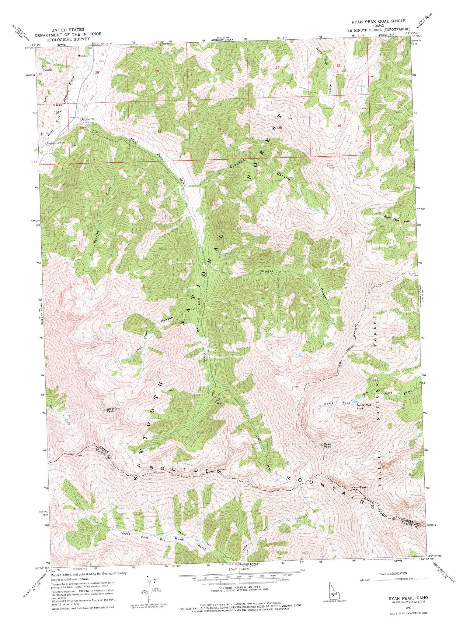
USGS Topo Quad 43114h4 - 1:24,000 scale
| Topo Map Name: | Ryan Peak |
| USGS Topo Quad ID: | 43114h4 |
| Print Size: | ca. 21 1/4" wide x 27" high |
| Southeast Coordinates: | 43.875° N latitude / 114.375° W longitude |
| Map Center Coordinates: | 43.9375° N latitude / 114.4375° W longitude |
| U.S. State: | ID |
| Filename: | o43114h4.jpg |
| Download Map JPG Image: | Ryan Peak topo map 1:24,000 scale |
| Map Type: | Topographic |
| Topo Series: | 7.5´ |
| Map Scale: | 1:24,000 |
| Source of Map Images: | United States Geological Survey (USGS) |
| Alternate Map Versions: |
Ryan Peak ID 1967, updated 1971 Download PDF Buy paper map Ryan Peak ID 1967, updated 1975 Download PDF Buy paper map Ryan Peak ID 2011 Download PDF Buy paper map Ryan Peak ID 2013 Download PDF Buy paper map |
| FStopo: | US Forest Service topo Ryan Peak is available: Download FStopo PDF Download FStopo TIF |
1:24,000 Topo Quads surrounding Ryan Peak
Robinson Bar |
Livingston Creek |
Potaman Peak |
Ziegler Basin |
The Paint Pot |
Washington Peak |
Boulder Chain Lakes |
Bowery Creek |
Bowery Peak |
Herd Lake |
Horton Peak |
Galena Peak |
Ryan Peak |
Meridian Peak |
Herd Peak |
Galena |
Easley Hot Springs |
Amber Lakes |
Rock Roll Canyon |
Phi Kappa Mountain |
Baker Peak |
Boyle Mountain |
Griffin Butte |
Sun Valley |
Hyndman Peak |
> Back to 43114e1 at 1:100,000 scale
> Back to 43114a1 at 1:250,000 scale
> Back to U.S. Topo Maps home
Ryan Peak topo map: Gazetteer
Ryan Peak: Lakes
North Fork Lake elevation 2847m 9340′Ryan Peak: Ranges
Boulder Mountains elevation 3566m 11699′Ryan Peak: Streams
Roaring Creek elevation 2118m 6948′West Pass Creek elevation 2036m 6679′
Ryan Peak: Summits
Glassford Peak elevation 3522m 11555′Kent Peak elevation 3209m 10528′
Ryan Peak elevation 3561m 11683′
Ryan Peak: Valleys
Cougar Canyon elevation 2242m 7355′Crooked Canyon elevation 2186m 7171′
Lost Mine Canyon elevation 2306m 7565′
Ryan Peak digital topo map on disk
Buy this Ryan Peak topo map showing relief, roads, GPS coordinates and other geographical features, as a high-resolution digital map file on DVD: