Mountain Home North Topo Map Idaho
To zoom in, hover over the map of Mountain Home North
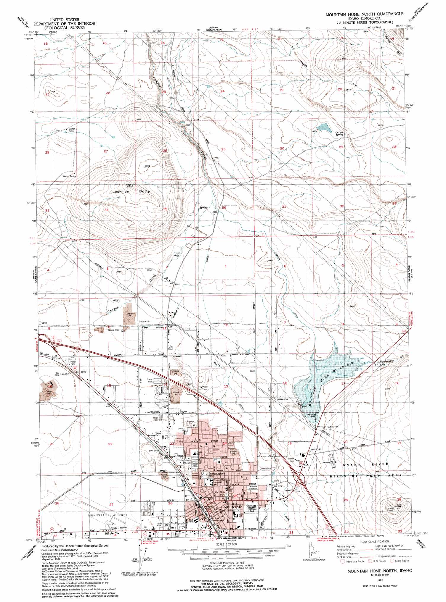
USGS Topo Quad 43115b6 - 1:24,000 scale
| Topo Map Name: | Mountain Home North |
| USGS Topo Quad ID: | 43115b6 |
| Print Size: | ca. 21 1/4" wide x 27" high |
| Southeast Coordinates: | 43.125° N latitude / 115.625° W longitude |
| Map Center Coordinates: | 43.1875° N latitude / 115.6875° W longitude |
| U.S. State: | ID |
| Filename: | o43115b6.jpg |
| Download Map JPG Image: | Mountain Home North topo map 1:24,000 scale |
| Map Type: | Topographic |
| Topo Series: | 7.5´ |
| Map Scale: | 1:24,000 |
| Source of Map Images: | United States Geological Survey (USGS) |
| Alternate Map Versions: |
Mountain Home North ID 1956, updated 1957 Download PDF Buy paper map Mountain Home North ID 1956, updated 1976 Download PDF Buy paper map Mountain Home North ID 1956, updated 1979 Download PDF Buy paper map Mountain Home North ID 1992, updated 1992 Download PDF Buy paper map Mountain Home North ID 2010 Download PDF Buy paper map Mountain Home North ID 2013 Download PDF Buy paper map |
1:24,000 Topo Quads surrounding Mountain Home North
Mayfield |
Braves Creek |
Danskin Peak |
Cathedral Rocks |
House Mountain |
Mayfield Sw |
Mayfield Se |
Syrup Creek |
Long Tom Reservoir |
Anderson Ranch Dam |
Cinder Cone Butte |
Crater Rings |
Mountain Home North |
Teapot Dome |
Bennett Mountain |
Crater Rings Sw |
Crater Rings Se |
Mountain Home South |
Reverse |
Hot Springs Creek Reservoir |
C J Strike Dam |
Bruneau |
Bruneau Dunes |
Indian Cove |
Hammett |
> Back to 43115a1 at 1:100,000 scale
> Back to 43114a1 at 1:250,000 scale
> Back to U.S. Topo Maps home
Mountain Home North topo map: Gazetteer
Mountain Home North: Airports
Mountain Home Municipal Airport elevation 964m 3162′Mountain Home North: Canals
Feeder Canal elevation 1012m 3320′Lamberton Canal elevation 1003m 3290′
Miller Canal elevation 986m 3234′
West Side Canal elevation 965m 3166′
Mountain Home North: Dams
Mountain Home Dam elevation 1001m 3284′Mountain Home North: Parks
Carl Miller Park elevation 959m 3146′East Side Park elevation 956m 3136′
Memorial Park elevation 959m 3146′
Railroad Park elevation 959m 3146′
Richard Aguirre Park elevation 962m 3156′
Mountain Home North: Populated Places
Mountain Home elevation 959m 3146′Mountain Home North: Reservoirs
Mountain Home Reservoir elevation 1001m 3284′Mountain Home North: Springs
Parker Spring elevation 1122m 3681′Mountain Home North: Streams
Rattlesnake Creek elevation 982m 3221′Mountain Home North: Summits
Lockman Butte elevation 1131m 3710′Mountain Home North digital topo map on disk
Buy this Mountain Home North topo map showing relief, roads, GPS coordinates and other geographical features, as a high-resolution digital map file on DVD: