Sprout Mountain Topo Map Idaho
To zoom in, hover over the map of Sprout Mountain
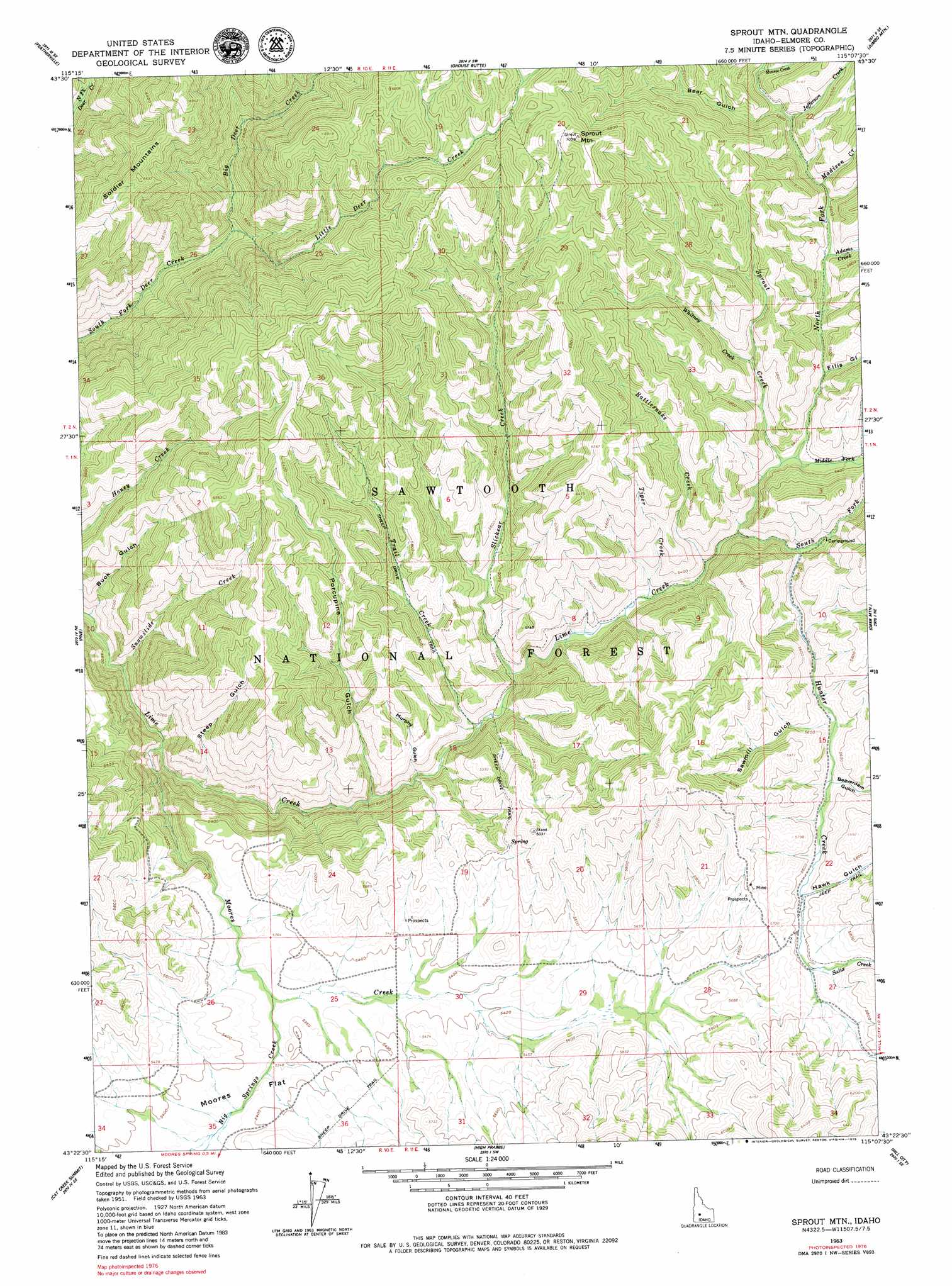
USGS Topo Quad 43115d2 - 1:24,000 scale
| Topo Map Name: | Sprout Mountain |
| USGS Topo Quad ID: | 43115d2 |
| Print Size: | ca. 21 1/4" wide x 27" high |
| Southeast Coordinates: | 43.375° N latitude / 115.125° W longitude |
| Map Center Coordinates: | 43.4375° N latitude / 115.1875° W longitude |
| U.S. State: | ID |
| Filename: | o43115d2.jpg |
| Download Map JPG Image: | Sprout Mountain topo map 1:24,000 scale |
| Map Type: | Topographic |
| Topo Series: | 7.5´ |
| Map Scale: | 1:24,000 |
| Source of Map Images: | United States Geological Survey (USGS) |
| Alternate Map Versions: |
Sprout Mtn ID 1963, updated 1964 Download PDF Buy paper map Sprout Mountain ID 2011 Download PDF Buy paper map Sprout Mountain ID 2013 Download PDF Buy paper map |
| FStopo: | US Forest Service topo Sprout Mountain is available: Download FStopo PDF Download FStopo TIF |
1:24,000 Topo Quads surrounding Sprout Mountain
Little Trinity Lake |
Rocky Bar |
Cayuse Point |
Ross Peak |
Newman Peak |
Trinity Mountain |
Featherville |
Grouse Butte |
Jumbo Mountain |
Boardman Creek |
House Mountain |
Pine |
Sprout Mountain |
Deer Mountain |
Smoky Dome |
Anderson Ranch Dam |
Cat Creek Summit |
High Prairie |
Hill City |
Corral |
Bennett Mountain |
Goodman Flat |
Deer Haven Mountain |
Dempsey Meadows |
Davis Mountain |
> Back to 43115a1 at 1:100,000 scale
> Back to 43114a1 at 1:250,000 scale
> Back to U.S. Topo Maps home
Sprout Mountain topo map: Gazetteer
Sprout Mountain: Flats
Moores Flat elevation 1638m 5374′Sprout Mountain: Streams
Adams Creek elevation 1686m 5531′Big Deer Creek elevation 1625m 5331′
Big Springs Creek elevation 1626m 5334′
Jefferson Creek elevation 1740m 5708′
Little Deer Creek elevation 1625m 5331′
Madison Creek elevation 1708m 5603′
Middle Fork Lime Creek elevation 1619m 5311′
Monroe Creek elevation 1787m 5862′
Moores Creek elevation 1410m 4625′
North Fork Lime Creek elevation 1585m 5200′
Rattlesnake Creek elevation 1572m 5157′
Salix Creek elevation 1708m 5603′
Slickear Creek elevation 1529m 5016′
Snowslide Creek elevation 1383m 4537′
South Fork Lime Creek elevation 1585m 5200′
Sprout Creek elevation 1617m 5305′
Tiger Creek elevation 1560m 5118′
Trail Creek elevation 1512m 4960′
Whitney Creek elevation 1703m 5587′
Sprout Mountain: Summits
Sprout Mountain elevation 2151m 7057′Sprout Mountain: Trails
Sheep Drive Trail elevation 1715m 5626′Sprout Mountain: Valleys
Bear Gulch elevation 1755m 5757′Beaverdam Gulch elevation 1676m 5498′
Buck Gulch elevation 1365m 4478′
Ellis Gulch elevation 1650m 5413′
Hawk Gulch elevation 1695m 5561′
Murphy Gulch elevation 1500m 4921′
Porcupine Gulch elevation 1487m 4878′
Sawmill Gulch elevation 1664m 5459′
Steep Gulch elevation 1463m 4799′
Sprout Mountain digital topo map on disk
Buy this Sprout Mountain topo map showing relief, roads, GPS coordinates and other geographical features, as a high-resolution digital map file on DVD: