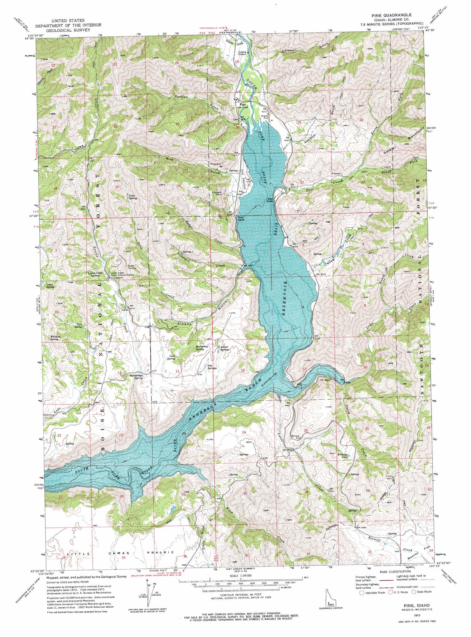
Pine Topo Map Idaho
To zoom in, hover over the map of Pine
USGS Topo Quad 43115d3 - 1:24,000 scale
| Topo Map Name: | Pine |
| USGS Topo Quad ID: | 43115d3 |
| Print Size: | ca. 21 1/4" wide x 27" high |
| Southeast Coordinates: | 43.375° N latitude / 115.25° W longitude |
| Map Center Coordinates: | 43.4375° N latitude / 115.3125° W longitude |
| U.S. State: | ID |
| Filename: | o43115d3.jpg |
| Download Map JPG Image: | Pine topo map 1:24,000 scale |
| Map Type: | Topographic |
| Topo Series: | 7.5´ |
| Map Scale: | 1:24,000 |
| Source of Map Images: | United States Geological Survey (USGS) |
| Alternate Map Versions: |
Pine ID 1973, updated 1977 Download PDF Buy paper map Pine ID 1973, updated 1977 Download PDF Buy paper map Pine ID 2011 Download PDF Buy paper map Pine ID 2013 Download PDF Buy paper map |
| FStopo: | US Forest Service topo Pine is available: Download FStopo PDF Download FStopo TIF |
1:24,000 Topo Quads surrounding Pine
Sheep Creek |
Little Trinity Lake |
Rocky Bar |
Cayuse Point |
Ross Peak |
Prairie |
Trinity Mountain |
Featherville |
Grouse Butte |
Jumbo Mountain |
Cathedral Rocks |
House Mountain |
Pine |
Sprout Mountain |
Deer Mountain |
Long Tom Reservoir |
Anderson Ranch Dam |
Cat Creek Summit |
High Prairie |
Hill City |
Teapot Dome |
Bennett Mountain |
Goodman Flat |
Deer Haven Mountain |
Dempsey Meadows |
> Back to 43115a1 at 1:100,000 scale
> Back to 43114a1 at 1:250,000 scale
> Back to U.S. Topo Maps home
Pine topo map: Gazetteer
Pine: Airports
Pine Airport elevation 1288m 4225′Pine: Lakes
Kerosene Lake elevation 1536m 5039′Pine: Mines
Franklin Mine elevation 1399m 4589′Pine: Populated Places
Pine elevation 1291m 4235′Pine: Post Offices
Pine Post Office (historical) elevation 1291m 4235′Pine: Springs
Abbott Springs elevation 1452m 4763′Bainbridge Spring elevation 1439m 4721′
Cook Spring elevation 1438m 4717′
Goat Spring elevation 1639m 5377′
Lester Creek Springs elevation 1501m 4924′
Light Spring elevation 1551m 5088′
McFarney Spring elevation 1426m 4678′
Orr Springs elevation 1448m 4750′
Tate Spring elevation 1486m 4875′
Whitson Spring elevation 1521m 4990′
Pine: Streams
Badger Creek elevation 1285m 4215′Casey Creek elevation 1280m 4199′
Curlew Creek elevation 1281m 4202′
Deer Creek elevation 1280m 4199′
Goat Creek elevation 1329m 4360′
Honey Creek elevation 1328m 4356′
Lester Creek elevation 1280m 4199′
Lime Creek elevation 1280m 4199′
Little Wood Creek elevation 1306m 4284′
Louse Creek elevation 1280m 4199′
North Fork Deer Creek elevation 1354m 4442′
Silverton Creek elevation 1286m 4219′
South Fork Deer Creek elevation 1354m 4442′
Towne Creek elevation 1293m 4242′
Wood Creek elevation 1280m 4199′
Pine: Valleys
Bird Gulch elevation 1306m 4284′Caldwell Gulch elevation 1307m 4288′
Cannon Gulch elevation 1295m 4248′
Skelton Gulch elevation 1291m 4235′
Sloans Gulch elevation 1280m 4199′
Pine digital topo map on disk
Buy this Pine topo map showing relief, roads, GPS coordinates and other geographical features, as a high-resolution digital map file on DVD: