Arrowrock Reservoir Ne Topo Map Idaho
To zoom in, hover over the map of Arrowrock Reservoir Ne
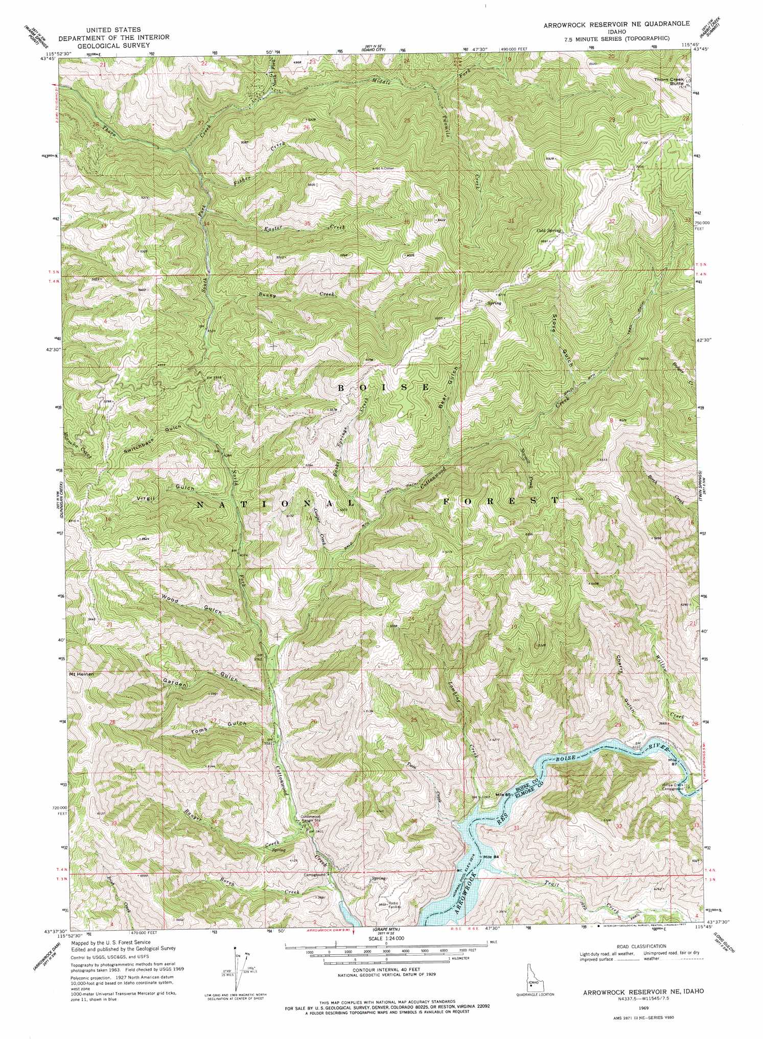
USGS Topo Quad 43115f7 - 1:24,000 scale
| Topo Map Name: | Arrowrock Reservoir Ne |
| USGS Topo Quad ID: | 43115f7 |
| Print Size: | ca. 21 1/4" wide x 27" high |
| Southeast Coordinates: | 43.625° N latitude / 115.75° W longitude |
| Map Center Coordinates: | 43.6875° N latitude / 115.8125° W longitude |
| U.S. State: | ID |
| Filename: | o43115f7.jpg |
| Download Map JPG Image: | Arrowrock Reservoir Ne topo map 1:24,000 scale |
| Map Type: | Topographic |
| Topo Series: | 7.5´ |
| Map Scale: | 1:24,000 |
| Source of Map Images: | United States Geological Survey (USGS) |
| Alternate Map Versions: |
Arrowrock Reservoir NE ID 1969, updated 1971 Download PDF Buy paper map Arrowrock Reservoir NE ID 1969, updated 1977 Download PDF Buy paper map Arrowrock Reservoir NE ID 2011 Download PDF Buy paper map Arrowrock Reservoir NE ID 2013 Download PDF Buy paper map |
| FStopo: | US Forest Service topo Arrowrock Reservoir NE is available: Download FStopo PDF Download FStopo TIF |
1:24,000 Topo Quads surrounding Arrowrock Reservoir Ne
Harris Creek Summit |
Placerville |
Pioneerville |
Sunset Mountain |
Big Owl Creek |
Shafer Butte |
Warm Springs Point |
Idaho City |
Rabbit Creek Summit |
Barber Flat |
Robie Creek |
Dunnigan Creek |
Arrowrock Reservoir Ne |
Twin Springs |
Sheep Creek |
Lucky Peak |
Arrowrock Dam |
Grape Mountain |
Long Gulch |
Prairie |
Indian Creek Reservoir |
Mayfield |
Braves Creek |
Danskin Peak |
Cathedral Rocks |
> Back to 43115e1 at 1:100,000 scale
> Back to 43114a1 at 1:250,000 scale
> Back to U.S. Topo Maps home
Arrowrock Reservoir Ne topo map: Gazetteer
Arrowrock Reservoir Ne: Streams
Basket Springs Creek elevation 1461m 4793′Boren Creek elevation 1079m 3540′
Bunny Creek elevation 1430m 4691′
Cougar Creek elevation 1420m 4658′
Easter Creek elevation 1369m 4491′
Fisher Creek elevation 1382m 4534′
Lambing Creek elevation 1053m 3454′
Middle Fork Thorn Creek elevation 1310m 4297′
North Fork Cottonwood Creek elevation 1271m 4169′
North Fork Thorn Creek elevation 1310m 4297′
Ranger Creek elevation 1117m 3664′
Sawmill Creek elevation 1579m 5180′
South Fork Thorn Creek elevation 1231m 4038′
Trail Creek elevation 985m 3231′
Twin Creek elevation 1122m 3681′
Twomile Creek elevation 1443m 4734′
Willow Creek elevation 985m 3231′
Arrowrock Reservoir Ne: Summits
Bald Mountain elevation 2279m 7477′Thorn Creek Butte elevation 2068m 6784′
Arrowrock Reservoir Ne: Valleys
Bear Gulch elevation 1596m 5236′Cherry Gulch elevation 1099m 3605′
Garden Gulch elevation 1256m 4120′
Slide Gulch elevation 985m 3231′
Stove Gulch elevation 1668m 5472′
Switchback Gulch elevation 1428m 4685′
Toms Gulch elevation 1211m 3973′
Virgil Gulch elevation 1349m 4425′
Wood Gulch elevation 1237m 4058′
Arrowrock Reservoir Ne digital topo map on disk
Buy this Arrowrock Reservoir Ne topo map showing relief, roads, GPS coordinates and other geographical features, as a high-resolution digital map file on DVD: