Warm Springs Point Topo Map Idaho
To zoom in, hover over the map of Warm Springs Point
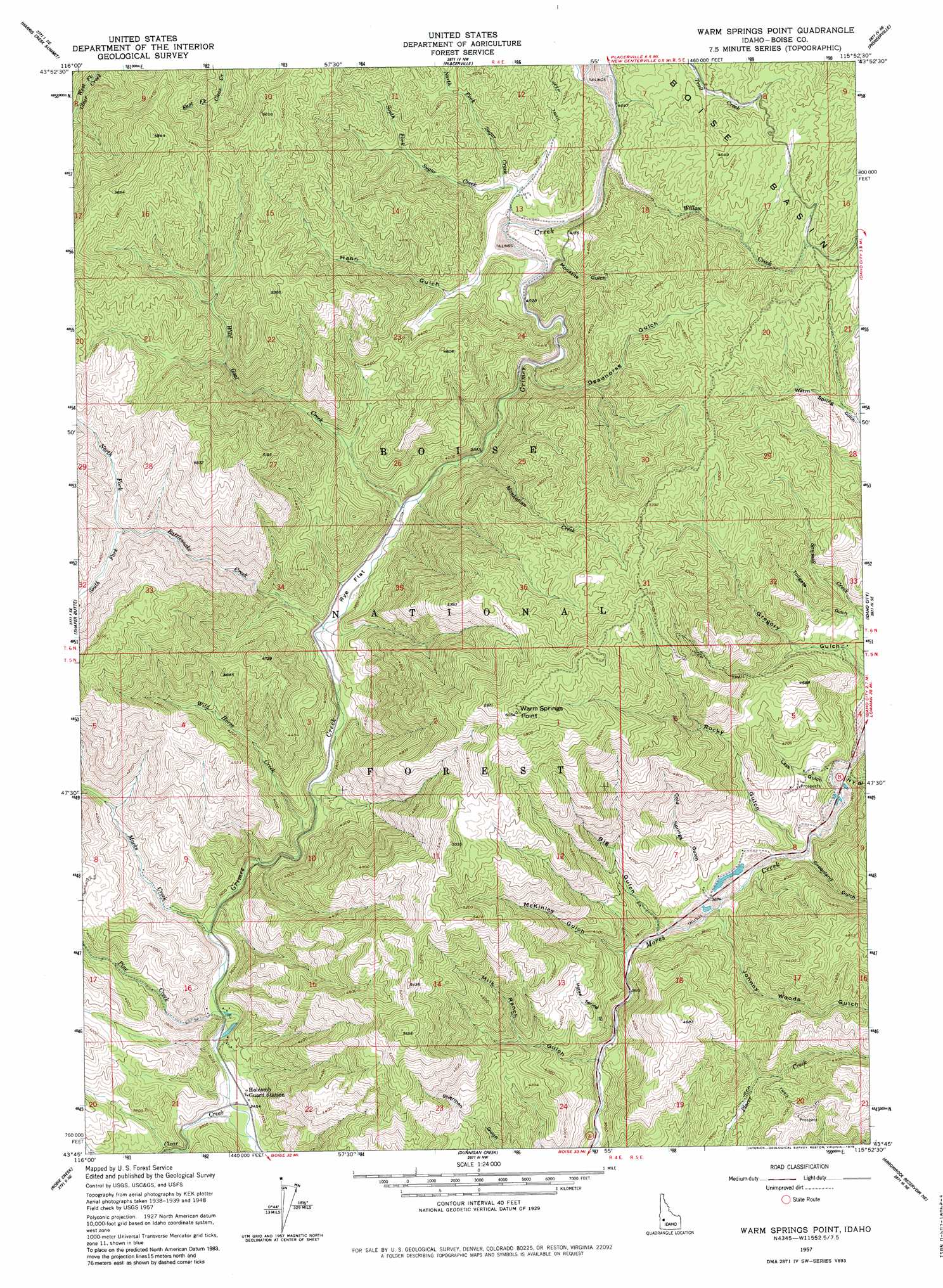
USGS Topo Quad 43115g8 - 1:24,000 scale
| Topo Map Name: | Warm Springs Point |
| USGS Topo Quad ID: | 43115g8 |
| Print Size: | ca. 21 1/4" wide x 27" high |
| Southeast Coordinates: | 43.75° N latitude / 115.875° W longitude |
| Map Center Coordinates: | 43.8125° N latitude / 115.9375° W longitude |
| U.S. State: | ID |
| Filename: | o43115g8.jpg |
| Download Map JPG Image: | Warm Springs Point topo map 1:24,000 scale |
| Map Type: | Topographic |
| Topo Series: | 7.5´ |
| Map Scale: | 1:24,000 |
| Source of Map Images: | United States Geological Survey (USGS) |
| Alternate Map Versions: |
Warm Springs Point ID 1957, updated 1959 Download PDF Buy paper map Warm Springs Point ID 1957, updated 1969 Download PDF Buy paper map Warm Springs Point ID 1957, updated 1979 Download PDF Buy paper map Warm Springs Point ID 1957, updated 1979 Download PDF Buy paper map Warm Springs Point ID 2011 Download PDF Buy paper map Warm Springs Point ID 2013 Download PDF Buy paper map |
| FStopo: | US Forest Service topo Warm Springs Point is available: Download FStopo PDF Download FStopo TIF |
1:24,000 Topo Quads surrounding Warm Springs Point
Dry Buck Valley |
Banks |
Garden Valley |
Grimes Pass |
Pine Flat |
Horseshoe Bend |
Harris Creek Summit |
Placerville |
Pioneerville |
Sunset Mountain |
Cartwright Canyon |
Shafer Butte |
Warm Springs Point |
Idaho City |
Rabbit Creek Summit |
Boise North |
Robie Creek |
Dunnigan Creek |
Arrowrock Reservoir Ne |
Twin Springs |
Boise South |
Lucky Peak |
Arrowrock Dam |
Grape Mountain |
Long Gulch |
> Back to 43115e1 at 1:100,000 scale
> Back to 43114a1 at 1:250,000 scale
> Back to U.S. Topo Maps home
Warm Springs Point topo map: Gazetteer
Warm Springs Point: Flats
Rye Flat elevation 1152m 3779′Warm Springs Point: Streams
Clear Creek elevation 1054m 3458′Granite Creek elevation 1269m 4163′
Macks Creek elevation 1076m 3530′
Manhattan Creek elevation 1182m 3877′
North Fork Rattlesnake Creek elevation 1402m 4599′
North Fork Sugar Creek elevation 1254m 4114′
Pine Creek elevation 1066m 3497′
Rattlesnake Creek elevation 1142m 3746′
South Fork Rattlesnake Creek elevation 1402m 4599′
South Fork Sugar Creek elevation 1254m 4114′
Sugar Creek elevation 1232m 4041′
Wild Goat Creek elevation 1166m 3825′
Wild Horse Creek elevation 1106m 3628′
Willow Creek elevation 1261m 4137′
Warm Springs Point: Summits
Casner Mountain elevation 1690m 5544′Warm Springs Point elevation 1838m 6030′
Warm Springs Point: Valleys
Big Gulch elevation 1121m 3677′Cold Springs Gulch elevation 1155m 3789′
Deadhorse Gulch elevation 1255m 4117′
Greenland Gulch elevation 1143m 3750′
Gregory Gulch elevation 1182m 3877′
Hahn Gulch elevation 1275m 4183′
Horse Spring Gulch elevation 1096m 3595′
Johnny Woods Gulch elevation 1129m 3704′
Lass Gulch elevation 1159m 3802′
McKinley Gulch elevation 1125m 3690′
Milk Ranch Gulch elevation 1086m 3562′
Monazite Gulch elevation 1229m 4032′
New York Gulch elevation 1161m 3809′
Rocky Gulch elevation 1145m 3756′
Warm Springs Point digital topo map on disk
Buy this Warm Springs Point topo map showing relief, roads, GPS coordinates and other geographical features, as a high-resolution digital map file on DVD: