Sunset Mountain Topo Map Idaho
To zoom in, hover over the map of Sunset Mountain
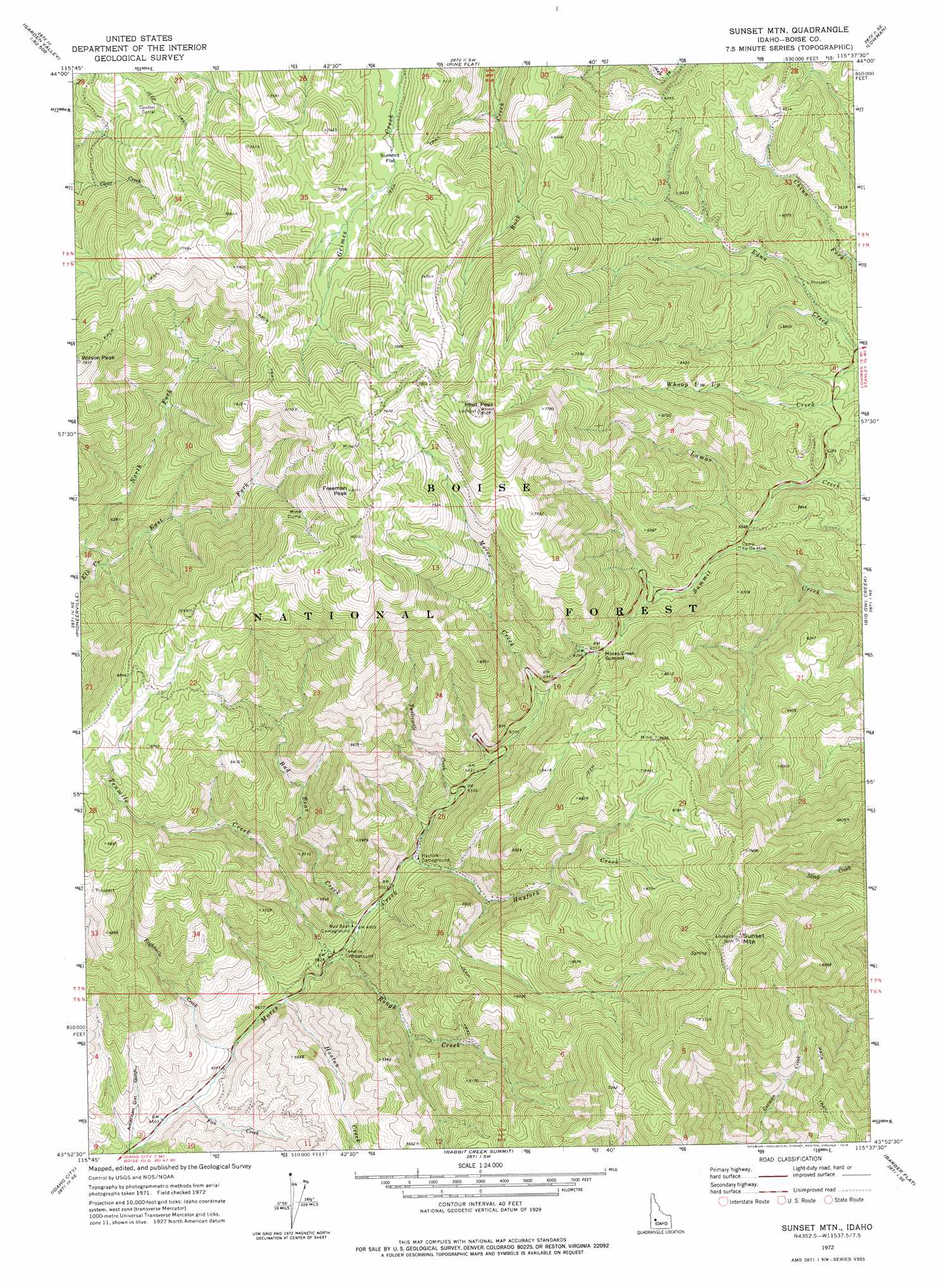
USGS Topo Quad 43115h6 - 1:24,000 scale
| Topo Map Name: | Sunset Mountain |
| USGS Topo Quad ID: | 43115h6 |
| Print Size: | ca. 21 1/4" wide x 27" high |
| Southeast Coordinates: | 43.875° N latitude / 115.625° W longitude |
| Map Center Coordinates: | 43.9375° N latitude / 115.6875° W longitude |
| U.S. State: | ID |
| Filename: | o43115h6.jpg |
| Download Map JPG Image: | Sunset Mountain topo map 1:24,000 scale |
| Map Type: | Topographic |
| Topo Series: | 7.5´ |
| Map Scale: | 1:24,000 |
| Source of Map Images: | United States Geological Survey (USGS) |
| Alternate Map Versions: |
Sunset Mtn. ID 1972, updated 1976 Download PDF Buy paper map Sunset Mtn. ID 1972, updated 1976 Download PDF Buy paper map Sunset Mtn. ID 1972, updated 1976 Download PDF Buy paper map Sunset Mountain ID 2011 Download PDF Buy paper map Sunset Mountain ID 2013 Download PDF Buy paper map |
| FStopo: | US Forest Service topo Sunset Mountain is available: Download FStopo PDF Download FStopo TIF |
1:24,000 Topo Quads surrounding Sunset Mountain
Pyle Creek |
Lightning Ridge |
Scott Creek |
Miller Mountain West |
Miller Mountain East |
Garden Valley |
Grimes Pass |
Pine Flat |
Lowman |
Jackson Peak |
Placerville |
Pioneerville |
Sunset Mountain |
Big Owl Creek |
Bear River |
Warm Springs Point |
Idaho City |
Rabbit Creek Summit |
Barber Flat |
Grand Mountain |
Dunnigan Creek |
Arrowrock Reservoir Ne |
Twin Springs |
Sheep Creek |
Little Trinity Lake |
> Back to 43115e1 at 1:100,000 scale
> Back to 43114a1 at 1:250,000 scale
> Back to U.S. Topo Maps home
Sunset Mountain topo map: Gazetteer
Sunset Mountain: Flats
Summit Flat elevation 2077m 6814′Sunset Mountain: Populated Places
Tenmile Summer Home Area elevation 1490m 4888′Sunset Mountain: Streams
Bad Bear Creek elevation 1487m 4878′East Fork Elk Creek elevation 1745m 5725′
Eightmile Creek elevation 1400m 4593′
Fan Creek elevation 1376m 4514′
Hayfork Creek elevation 1548m 5078′
Hooton Creek elevation 1435m 4708′
North Fork Elk Creek elevation 1744m 5721′
Rough Creek elevation 1464m 4803′
Tenmile Creek elevation 1466m 4809′
Twelvemile Creek elevation 1597m 5239′
Sunset Mountain: Summits
Freeman Peak elevation 2467m 8093′Mores Creek Summit elevation 1864m 6115′
Pilot Peak elevation 2466m 8090′
Sunset Mountain elevation 2393m 7851′
Sunset Mountain: Valleys
American Girl Gulch elevation 1357m 4452′Sunset Mountain digital topo map on disk
Buy this Sunset Mountain topo map showing relief, roads, GPS coordinates and other geographical features, as a high-resolution digital map file on DVD: