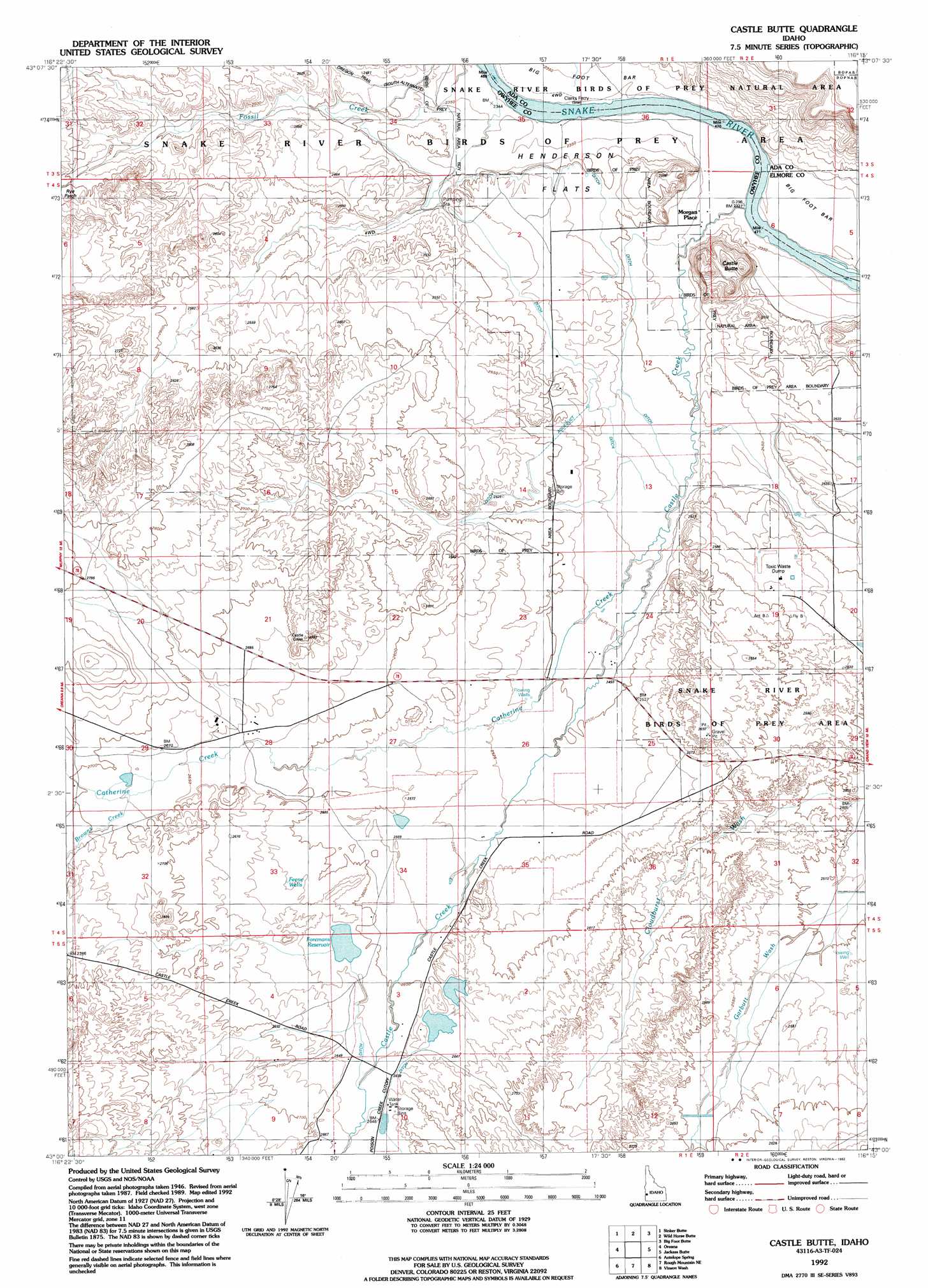
Castle Butte Topo Map Idaho
To zoom in, hover over the map of Castle Butte
USGS Topo Quad 43116a3 - 1:24,000 scale
| Topo Map Name: | Castle Butte |
| USGS Topo Quad ID: | 43116a3 |
| Print Size: | ca. 21 1/4" wide x 27" high |
| Southeast Coordinates: | 43° N latitude / 116.25° W longitude |
| Map Center Coordinates: | 43.0625° N latitude / 116.3125° W longitude |
| U.S. State: | ID |
| Filename: | o43116a3.jpg |
| Download Map JPG Image: | Castle Butte topo map 1:24,000 scale |
| Map Type: | Topographic |
| Topo Series: | 7.5´ |
| Map Scale: | 1:24,000 |
| Source of Map Images: | United States Geological Survey (USGS) |
| Alternate Map Versions: |
Castle Butte ID 1948 Download PDF Buy paper map Castle Butte ID 1948, updated 1985 Download PDF Buy paper map Castle Butte ID 1992, updated 1992 Download PDF Buy paper map Castle Butte ID 2010 Download PDF Buy paper map Castle Butte ID 2013 Download PDF Buy paper map |
1:24,000 Topo Quads surrounding Castle Butte
Walters Butte |
Initial Point |
Coyote Butte |
Christmas Mountain |
Orchard |
Murphy |
Sinker Butte |
Wild Horse Butte |
Big Foot Butte |
Little Joe Butte |
Sinker Canyon |
Oreana |
Castle Butte |
Jackass Butte |
Dorsey Butte |
Toy Pass |
Antelope Spring |
Rough Mountain Ne |
Vinson Wash |
Grand View |
Triangle Reservoir |
Pixley Basin |
Rough Mountain |
Perjue Canyon |
Chalk Hills |
> Back to 43116a1 at 1:100,000 scale
> Back to 43116a1 at 1:250,000 scale
> Back to U.S. Topo Maps home
Castle Butte topo map: Gazetteer
Castle Butte: Dams
Foreman Dam elevation 799m 2621′Castle Butte: Flats
Henderson Flats elevation 734m 2408′Castle Butte: Populated Places
Morgan Place elevation 714m 2342′Castle Butte: Reservoirs
Foremans Reservoir elevation 799m 2621′Castle Butte: Streams
Browns Creek elevation 815m 2673′Castle Creek elevation 709m 2326′
Catherine Creek elevation 742m 2434′
Garbutt Wash elevation 759m 2490′
Castle Butte: Summits
Castle Butte elevation 805m 2641′Castle Butte: Trails
Oregon Trail - South Alternate elevation 763m 2503′Castle Butte: Wells
Feeny Wells elevation 801m 2627′Castle Butte digital topo map on disk
Buy this Castle Butte topo map showing relief, roads, GPS coordinates and other geographical features, as a high-resolution digital map file on DVD: