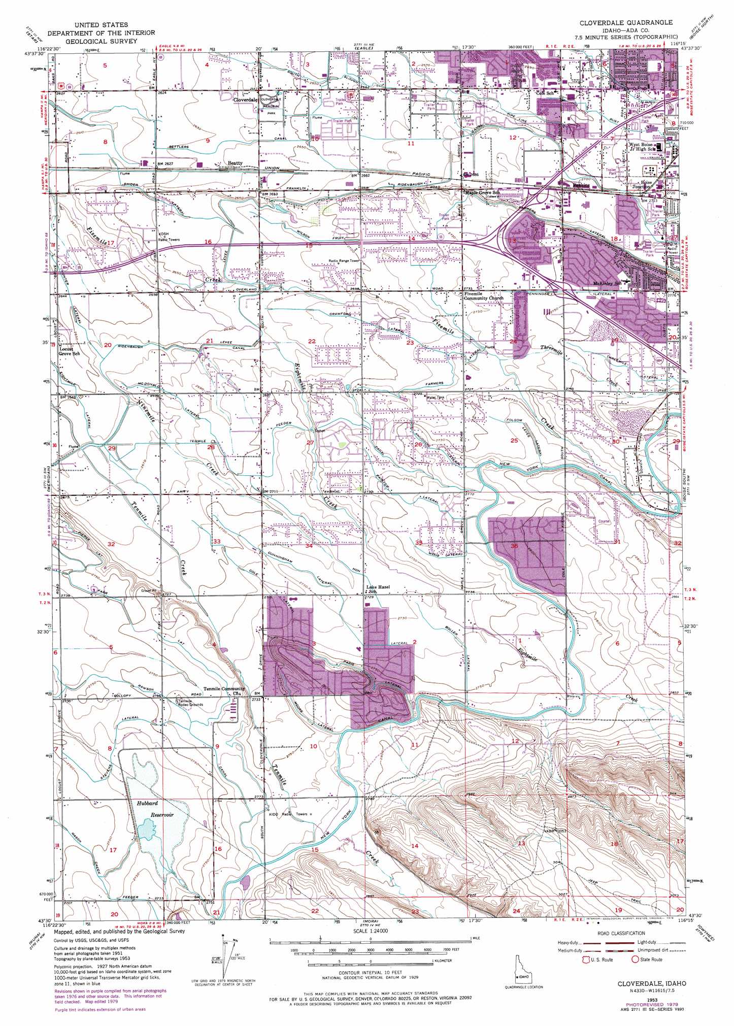
Cloverdale Topo Map Idaho
To zoom in, hover over the map of Cloverdale
USGS Topo Quad 43116e3 - 1:24,000 scale
| Topo Map Name: | Cloverdale |
| USGS Topo Quad ID: | 43116e3 |
| Print Size: | ca. 21 1/4" wide x 27" high |
| Southeast Coordinates: | 43.5° N latitude / 116.25° W longitude |
| Map Center Coordinates: | 43.5625° N latitude / 116.3125° W longitude |
| U.S. State: | ID |
| Filename: | o43116e3.jpg |
| Download Map JPG Image: | Cloverdale topo map 1:24,000 scale |
| Map Type: | Topographic |
| Topo Series: | 7.5´ |
| Map Scale: | 1:24,000 |
| Source of Map Images: | United States Geological Survey (USGS) |
| Alternate Map Versions: |
Cloverdale ID 1953, updated 1955 Download PDF Buy paper map Cloverdale ID 1953, updated 1970 Download PDF Buy paper map Cloverdale ID 1953, updated 1972 Download PDF Buy paper map Cloverdale ID 1953, updated 1979 Download PDF Buy paper map Cloverdale ID 1998, updated 2002 Download PDF Buy paper map Cloverdale ID 2010 Download PDF Buy paper map Cloverdale ID 2013 Download PDF Buy paper map |
1:24,000 Topo Quads surrounding Cloverdale
Southwest Emmett |
Southeast Emmett |
Pearl |
Cartwright Canyon |
Shafer Butte |
Middleton |
Star |
Eagle |
Boise North |
Robie Creek |
Nampa |
Meridian |
Cloverdale |
Boise South |
Lucky Peak |
Melba |
Kuna |
Mora |
Owyhee |
Indian Creek Reservoir |
Walters Butte |
Initial Point |
Coyote Butte |
Christmas Mountain |
Orchard |
> Back to 43116e1 at 1:100,000 scale
> Back to 43116a1 at 1:250,000 scale
> Back to U.S. Topo Maps home
Cloverdale topo map: Gazetteer
Cloverdale: Airports
Nampa Valley Heliport elevation 873m 2864′Saint Alphonsus Helistop elevation 828m 2716′
Cloverdale: Canals
Boller Lateral elevation 836m 2742′Cole Lateral elevation 831m 2726′
Crawford Lateral elevation 823m 2700′
Cunningham Lateral elevation 832m 2729′
Farmers Lateral elevation 830m 2723′
Farr Lateral elevation 840m 2755′
Folsom Lateral elevation 844m 2769′
Hon Lateral elevation 833m 2732′
Knudson Lateral elevation 845m 2772′
McDonald Lateral elevation 820m 2690′
Moore Lateral elevation 845m 2772′
Painter Lateral elevation 841m 2759′
Paris Lateral elevation 846m 2775′
Pierce Lateral elevation 836m 2742′
Rust Lateral elevation 827m 2713′
Settlers Canal elevation 803m 2634′
Snider Lateral elevation 810m 2657′
Stevens Lateral elevation 833m 2732′
Tenmile Feeder Canal elevation 826m 2709′
Threemile Lateral elevation 844m 2769′
Wilson Fruit Lateral elevation 823m 2700′
Wood Lateral elevation 844m 2769′
Cloverdale: Dams
Hubbard Dam elevation 830m 2723′Cloverdale: Populated Places
Beatty elevation 806m 2644′Boise Junction elevation 829m 2719′
Cloverdale elevation 806m 2644′
Perkins elevation 824m 2703′
Cloverdale: Reservoirs
Hubbard Reservoir elevation 830m 2723′Cloverdale: Streams
Eightmile Creek elevation 815m 2673′Threemile Creek elevation 831m 2726′
Cloverdale digital topo map on disk
Buy this Cloverdale topo map showing relief, roads, GPS coordinates and other geographical features, as a high-resolution digital map file on DVD: