Nampa Topo Map Idaho
To zoom in, hover over the map of Nampa
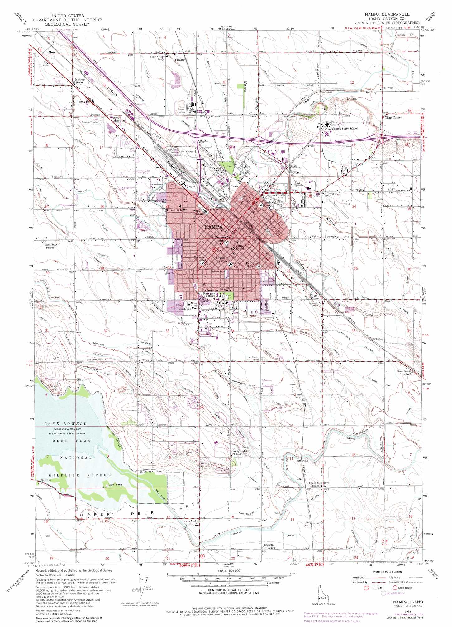
USGS Topo Quad 43116e5 - 1:24,000 scale
| Topo Map Name: | Nampa |
| USGS Topo Quad ID: | 43116e5 |
| Print Size: | ca. 21 1/4" wide x 27" high |
| Southeast Coordinates: | 43.5° N latitude / 116.5° W longitude |
| Map Center Coordinates: | 43.5625° N latitude / 116.5625° W longitude |
| U.S. State: | ID |
| Filename: | o43116e5.jpg |
| Download Map JPG Image: | Nampa topo map 1:24,000 scale |
| Map Type: | Topographic |
| Topo Series: | 7.5´ |
| Map Scale: | 1:24,000 |
| Source of Map Images: | United States Geological Survey (USGS) |
| Alternate Map Versions: |
Nampa ID 1958, updated 1960 Download PDF Buy paper map Nampa ID 1958, updated 1973 Download PDF Buy paper map Nampa ID 1958, updated 1981 Download PDF Buy paper map Nampa ID 1958, updated 1981 Download PDF Buy paper map Nampa ID 2010 Download PDF Buy paper map Nampa ID 2013 Download PDF Buy paper map |
1:24,000 Topo Quads surrounding Nampa
Parma Se |
Sand Hollow |
Southwest Emmett |
Southeast Emmett |
Pearl |
Notus |
Caldwell |
Middleton |
Star |
Eagle |
Marsing |
Lake Lowell |
Nampa |
Meridian |
Cloverdale |
Opalene Gulch |
Givens Hot Springs |
Melba |
Kuna |
Mora |
Soldier Cap |
Wilson Peak |
Walters Butte |
Initial Point |
Coyote Butte |
> Back to 43116e1 at 1:100,000 scale
> Back to 43116a1 at 1:250,000 scale
> Back to U.S. Topo Maps home
Nampa topo map: Gazetteer
Nampa: Airports
Mercy Heliport elevation 763m 2503′Nampa Municipal Airport elevation 772m 2532′
Nampa: Canals
15.0 Lateral elevation 752m 2467′15.0 North Branch Lateral elevation 746m 2447′
15.0 South Branch Lateral elevation 746m 2447′
9.8 Lateral elevation 758m 2486′
Burke Lateral elevation 781m 2562′
Edwards Lateral elevation 760m 2493′
Elijah Drain elevation 757m 2483′
Herron Lateral elevation 788m 2585′
Langdon Lateral elevation 787m 2582′
Middle Lateral elevation 752m 2467′
North Nampa Lateral elevation 788m 2585′
North Robinson Lateral elevation 786m 2578′
Partridge Lateral elevation 776m 2545′
Peters Lateral elevation 757m 2483′
Phyllis Canal elevation 759m 2490′
Purdam Gulch Drain elevation 794m 2604′
South Nampa Lateral elevation 791m 2595′
West Lateral elevation 751m 2463′
Nampa: Flats
Upper Deer Flat elevation 776m 2545′Nampa: Islands
Gull Island elevation 774m 2539′Nampa: Parks
Kurtz Park elevation 775m 2542′Lakeview Park elevation 779m 2555′
Nampa: Populated Places
Deal elevation 781m 2562′Fischer elevation 748m 2454′
Karcher Junction elevation 751m 2463′
Kings Corner elevation 788m 2585′
Moss elevation 743m 2437′
Nampa elevation 767m 2516′
Swartz Corner elevation 786m 2578′
Tiegs Corner elevation 781m 2562′
Nampa: Post Offices
Nampa Post Office elevation 759m 2490′Nampa: Rapids
Alum Bed Rapids elevation 787m 2582′Hutton Gulch Rapids elevation 778m 2552′
Nampa: Streams
12th Ave Drain elevation 775m 2542′Aaron Drain elevation 776m 2545′
Grimes Drain elevation 769m 2522′
Nampa digital topo map on disk
Buy this Nampa topo map showing relief, roads, GPS coordinates and other geographical features, as a high-resolution digital map file on DVD: