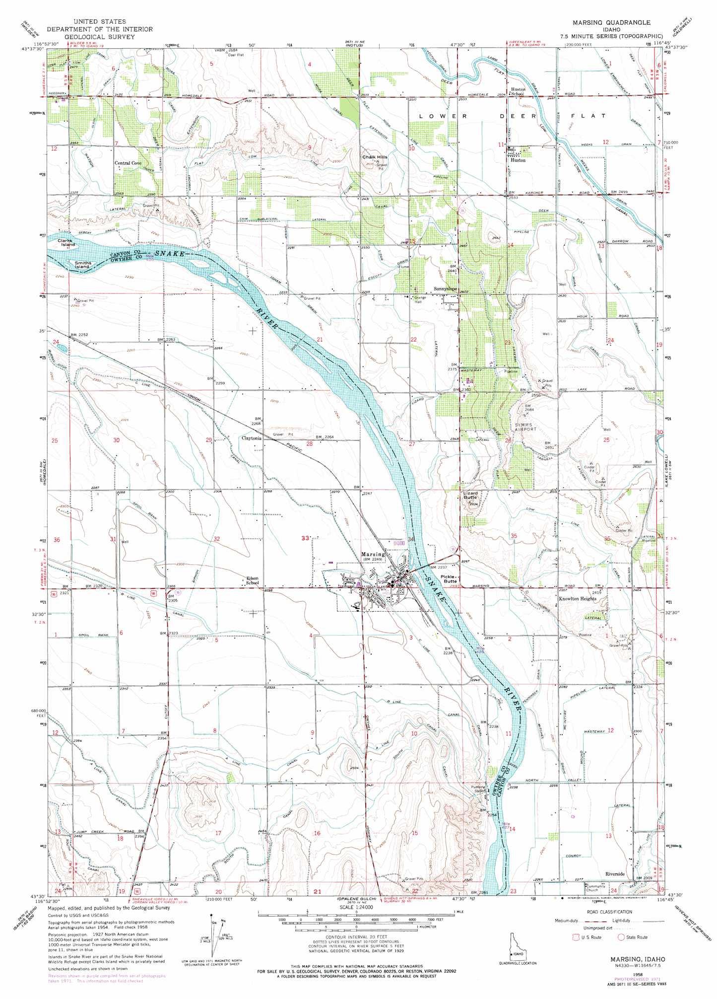
Marsing Topo Map Idaho
To zoom in, hover over the map of Marsing
USGS Topo Quad 43116e7 - 1:24,000 scale
| Topo Map Name: | Marsing |
| USGS Topo Quad ID: | 43116e7 |
| Print Size: | ca. 21 1/4" wide x 27" high |
| Southeast Coordinates: | 43.5° N latitude / 116.75° W longitude |
| Map Center Coordinates: | 43.5625° N latitude / 116.8125° W longitude |
| U.S. State: | ID |
| Filename: | o43116e7.jpg |
| Download Map JPG Image: | Marsing topo map 1:24,000 scale |
| Map Type: | Topographic |
| Topo Series: | 7.5´ |
| Map Scale: | 1:24,000 |
| Source of Map Images: | United States Geological Survey (USGS) |
| Alternate Map Versions: |
Marsing ID 1958, updated 1960 Download PDF Buy paper map Marsing ID 1958, updated 1972 Download PDF Buy paper map Marsing ID 1958, updated 1977 Download PDF Buy paper map Marsing ID 2010 Download PDF Buy paper map Marsing ID 2013 Download PDF Buy paper map |
1:24,000 Topo Quads surrounding Marsing
Owyhee |
Parma |
Parma Se |
Sand Hollow |
Southwest Emmett |
Adrian |
Wilder |
Notus |
Caldwell |
Middleton |
Graveyard Point |
Homedale |
Marsing |
Lake Lowell |
Nampa |
Pole Creek Top |
Jump Creek Canyon |
Opalene Gulch |
Givens Hot Springs |
Melba |
Rockville |
Piute Butte |
Soldier Cap |
Wilson Peak |
Walters Butte |
> Back to 43116e1 at 1:100,000 scale
> Back to 43116a1 at 1:250,000 scale
> Back to U.S. Topo Maps home
Marsing topo map: Gazetteer
Marsing: Airports
Symms Airport elevation 819m 2687′Whelans Heliport elevation 782m 2565′
Marsing: Canals
Bohlson Lateral elevation 769m 2522′C Line Canal elevation 696m 2283′
Conroy Lateral elevation 693m 2273′
Crim Sublateral Lateral elevation 706m 2316′
Deer Flat Low Line Canal elevation 745m 2444′
East Valley Mound Wasteway elevation 695m 2280′
Escott Drain elevation 713m 2339′
Fisk Sublateral elevation 778m 2552′
Frohman Wasteway elevation 733m 2404′
Fuger Lateral elevation 761m 2496′
Gebert Drain elevation 678m 2224′
Isham Drain elevation 683m 2240′
Lamm Drain elevation 762m 2500′
Lizar Lateral elevation 715m 2345′
Lizard Wasteway elevation 715m 2345′
Lower Embankment Drain elevation 760m 2493′
McIntyre Lateral elevation 697m 2286′
Mitchel Drain elevation 684m 2244′
Mutch Lateral elevation 718m 2355′
Needham Lateral elevation 735m 2411′
Norris Lateral elevation 700m 2296′
North Valley Mound Wasteway elevation 697m 2286′
Olson Drain elevation 728m 2388′
Penninger Drain elevation 683m 2240′
Scholtie Lateral elevation 775m 2542′
Sturgeon Lateral elevation 738m 2421′
Sunnyslope Lateral elevation 720m 2362′
Tinker Lateral elevation 734m 2408′
Vasold Lateral elevation 766m 2513′
Weeks Drain elevation 762m 2500′
Yarnell Lateral elevation 790m 2591′
Marsing: Flats
Lower Deer Flat elevation 761m 2496′Marsing: Islands
Clarks Island elevation 679m 2227′Smiths Island elevation 679m 2227′
Marsing: Populated Places
Central Cove elevation 725m 2378′Claytonia elevation 687m 2253′
Huston elevation 768m 2519′
Knowlton Heights elevation 721m 2365′
Marsing elevation 701m 2299′
Riverside elevation 695m 2280′
Sunnyslope elevation 731m 2398′
Marsing: Ranges
Chalk Hills elevation 779m 2555′Marsing: Summits
Lizard Butte elevation 793m 2601′Pickle Butte elevation 689m 2260′
Marsing digital topo map on disk
Buy this Marsing topo map showing relief, roads, GPS coordinates and other geographical features, as a high-resolution digital map file on DVD: