Eagle Topo Map Idaho
To zoom in, hover over the map of Eagle
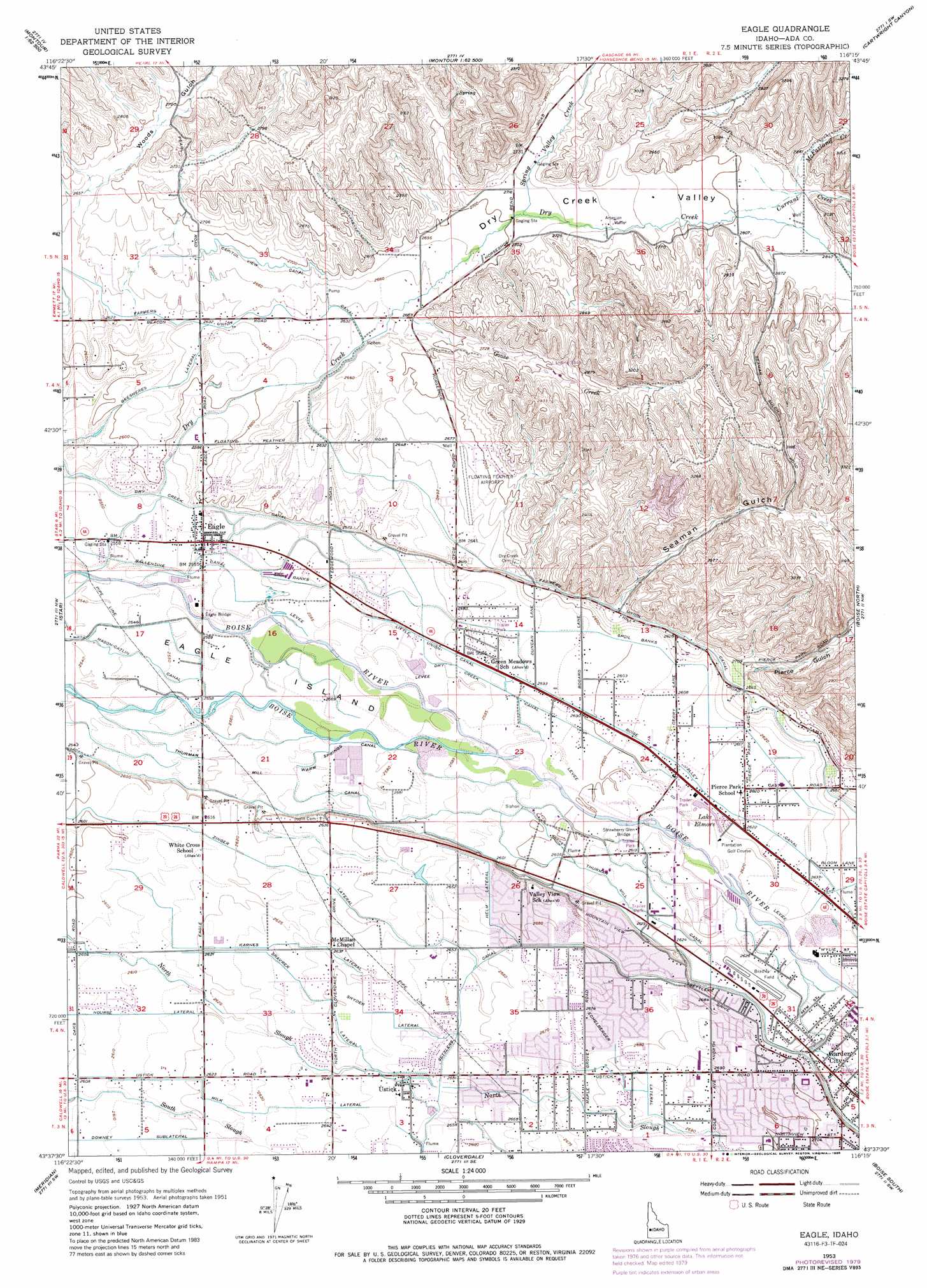
USGS Topo Quad 43116f3 - 1:24,000 scale
| Topo Map Name: | Eagle |
| USGS Topo Quad ID: | 43116f3 |
| Print Size: | ca. 21 1/4" wide x 27" high |
| Southeast Coordinates: | 43.625° N latitude / 116.25° W longitude |
| Map Center Coordinates: | 43.6875° N latitude / 116.3125° W longitude |
| U.S. State: | ID |
| Filename: | o43116f3.jpg |
| Download Map JPG Image: | Eagle topo map 1:24,000 scale |
| Map Type: | Topographic |
| Topo Series: | 7.5´ |
| Map Scale: | 1:24,000 |
| Source of Map Images: | United States Geological Survey (USGS) |
| Alternate Map Versions: |
Eagle ID 1953, updated 1955 Download PDF Buy paper map Eagle ID 1953, updated 1973 Download PDF Buy paper map Eagle ID 1953, updated 1979 Download PDF Buy paper map Eagle ID 1953, updated 1986 Download PDF Buy paper map Eagle ID 1953, updated 1986 Download PDF Buy paper map Eagle ID 1998, updated 2002 Download PDF Buy paper map Eagle ID 2010 Download PDF Buy paper map Eagle ID 2013 Download PDF Buy paper map |
1:24,000 Topo Quads surrounding Eagle
Northwest Emmett |
Northeast Emmett |
Montour |
Horseshoe Bend |
Harris Creek Summit |
Southwest Emmett |
Southeast Emmett |
Pearl |
Cartwright Canyon |
Shafer Butte |
Middleton |
Star |
Eagle |
Boise North |
Robie Creek |
Nampa |
Meridian |
Cloverdale |
Boise South |
Lucky Peak |
Melba |
Kuna |
Mora |
Owyhee |
Indian Creek Reservoir |
> Back to 43116e1 at 1:100,000 scale
> Back to 43116a1 at 1:250,000 scale
> Back to U.S. Topo Maps home
Eagle topo map: Gazetteer
Eagle: Airports
Bradley Field elevation 803m 2634′Floating Feather Airport elevation 814m 2670′
Glider Airport elevation 860m 2821′
Strawberry Glen Airport elevation 794m 2604′
Eagle: Bridges
Eagle Bridge elevation 779m 2555′Strawberry Glen Bridge elevation 795m 2608′
Eagle: Canals
Ballentine Canal elevation 780m 2559′Boise Valley Canal elevation 800m 2624′
Bresheres Lateral elevation 798m 2618′
Capitol View Canal elevation 820m 2690′
Downey Sublateral elevation 797m 2614′
Dry Creek Canal elevation 785m 2575′
Echelberger Lateral elevation 818m 2683′
Helm Lateral elevation 810m 2657′
Karnes Lateral elevation 802m 2631′
Little Union Canal elevation 788m 2585′
Mason-Catlin Canal elevation 777m 2549′
Milk Lateral elevation 803m 2634′
Nourse Lateral elevation 797m 2614′
Shavrer Lateral elevation 806m 2644′
Snyder Lateral elevation 807m 2647′
Thurman Mill Canal elevation 795m 2608′
Warm Springs Canal elevation 784m 2572′
Zinger Lateral elevation 802m 2631′
Eagle: Lakes
Lake Elmore elevation 798m 2618′Eagle: Parks
Winstead Park elevation 825m 2706′Eagle: Populated Places
Eagle elevation 782m 2565′Ustick elevation 809m 2654′
Eagle: Streams
Currant Creek elevation 854m 2801′Dry Creek elevation 775m 2542′
Goose Creek elevation 816m 2677′
McFarland Creek elevation 861m 2824′
Spring Valley Creek elevation 826m 2709′
Eagle: Valleys
Dry Creek Valley elevation 806m 2644′Pierce Gulch elevation 843m 2765′
Seaman Gulch elevation 811m 2660′
Woods Gulch elevation 811m 2660′
Eagle digital topo map on disk
Buy this Eagle topo map showing relief, roads, GPS coordinates and other geographical features, as a high-resolution digital map file on DVD: