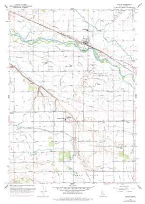
Notus Topo Map Idaho
To zoom in, hover over the map of Notus
USGS Topo Quad 43116f7 - 1:24,000 scale
| Topo Map Name: | Notus |
| USGS Topo Quad ID: | 43116f7 |
| Print Size: | ca. 21 1/4" wide x 27" high |
| Southeast Coordinates: | 43.625° N latitude / 116.75° W longitude |
| Map Center Coordinates: | 43.6875° N latitude / 116.8125° W longitude |
| U.S. State: | ID |
| Filename: | o43116f7.jpg |
| Download Map JPG Image: | Notus topo map 1:24,000 scale |
| Map Type: | Topographic |
| Topo Series: | 7.5´ |
| Map Scale: | 1:24,000 |
| Source of Map Images: | United States Geological Survey (USGS) |
| Alternate Map Versions: |
Notus ID 1957, updated 1960 Download PDF Buy paper map Notus ID 1957, updated 1972 Download PDF Buy paper map Notus ID 1957, updated 1978 Download PDF Buy paper map Notus ID 2010 Download PDF Buy paper map Notus ID 2013 Download PDF Buy paper map |
1:24,000 Topo Quads surrounding Notus
> Back to 43116e1 at 1:100,000 scale
> Back to 43116a1 at 1:250,000 scale
> Back to U.S. Topo Maps home
Notus topo map: Gazetteer
Notus: Airports
Davison Ranch Airport elevation 721m 2365′Frank Field elevation 708m 2322′
Notus: Canals
Allen Lateral elevation 737m 2417′Beal Lateral elevation 738m 2421′
Boone Ditch elevation 693m 2273′
Dailey Lateral elevation 757m 2483′
Deer Flat North Canal elevation 761m 2496′
Dickens Drain elevation 722m 2368′
Dotson Drain elevation 760m 2493′
Eureka Canal elevation 701m 2299′
Fowler Lateral elevation 761m 2496′
Greenleaf Drain elevation 738m 2421′
Holcomb Drain elevation 718m 2355′
Lower Bartlett Lateral elevation 757m 2483′
Lower Center Point Canal elevation 704m 2309′
Mora Canal Extension elevation 779m 2555′
Mumford Lateral elevation 702m 2303′
Myers Drain elevation 756m 2480′
North Drain elevation 703m 2306′
North Drain elevation 696m 2283′
Pickup Drain elevation 751m 2463′
Rhoads Lateral elevation 738m 2421′
Riverside Canal elevation 695m 2280′
Shelp Gulch Drain elevation 728m 2388′
South Drain elevation 704m 2309′
Super Lateral elevation 737m 2417′
Upper Center Point Canal elevation 705m 2312′
West End Drain elevation 708m 2322′
Notus: Dams
Golden Gate Drop elevation 753m 2470′Notus: Populated Places
Allendale elevation 739m 2424′Doles elevation 707m 2319′
Greenleaf elevation 735m 2411′
Notus elevation 706m 2316′
Weitz elevation 708m 2322′
Notus: Valleys
Benson Gulch elevation 710m 2329′Christian Gulch elevation 693m 2273′
Conway Gulch elevation 714m 2342′
Dixie Gulch elevation 709m 2326′
Guess Gulch elevation 704m 2309′
Pipe Gulch elevation 718m 2355′
Notus: Wells
Street Well elevation 718m 2355′Notus digital topo map on disk
Buy this Notus topo map showing relief, roads, GPS coordinates and other geographical features, as a high-resolution digital map file on DVD:


