Shafer Butte Topo Map Idaho
To zoom in, hover over the map of Shafer Butte
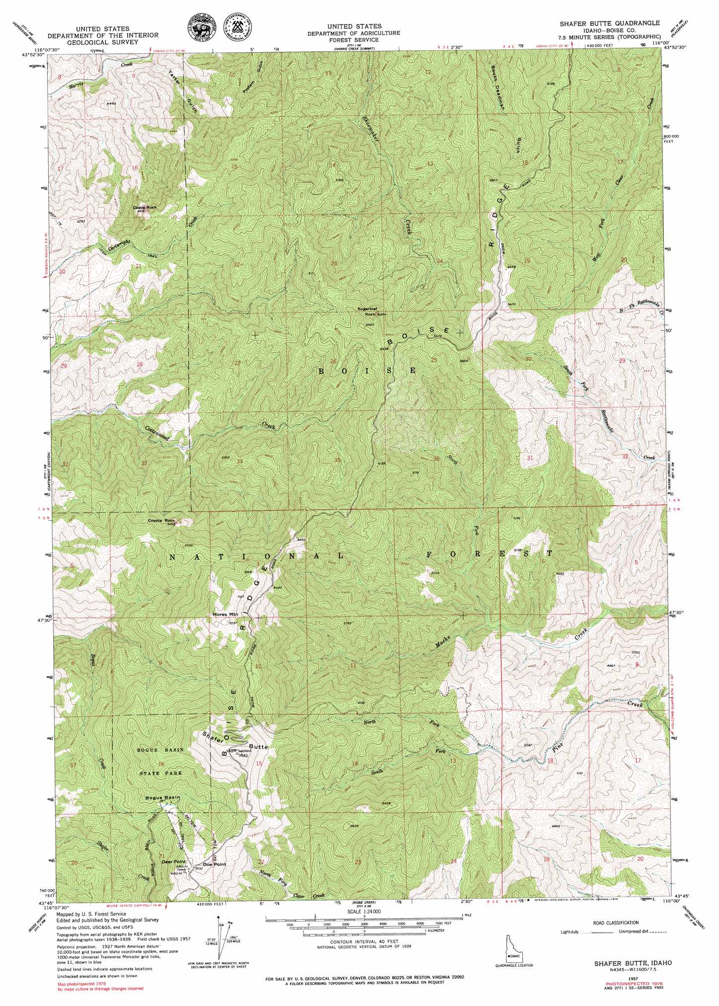
USGS Topo Quad 43116g1 - 1:24,000 scale
| Topo Map Name: | Shafer Butte |
| USGS Topo Quad ID: | 43116g1 |
| Print Size: | ca. 21 1/4" wide x 27" high |
| Southeast Coordinates: | 43.75° N latitude / 116° W longitude |
| Map Center Coordinates: | 43.8125° N latitude / 116.0625° W longitude |
| U.S. State: | ID |
| Filename: | o43116g1.jpg |
| Download Map JPG Image: | Shafer Butte topo map 1:24,000 scale |
| Map Type: | Topographic |
| Topo Series: | 7.5´ |
| Map Scale: | 1:24,000 |
| Source of Map Images: | United States Geological Survey (USGS) |
| Alternate Map Versions: |
Shafer Butte ID 1957, updated 1959 Download PDF Buy paper map Shafer Butte ID 1957, updated 1969 Download PDF Buy paper map Shafer Butte ID 1957, updated 1979 Download PDF Buy paper map Shafer Butte ID 1957, updated 1979 Download PDF Buy paper map Shafer Butte ID 2011 Download PDF Buy paper map Shafer Butte ID 2013 Download PDF Buy paper map |
| FStopo: | US Forest Service topo Shafer Butte is available: Download FStopo PDF Download FStopo TIF |
1:24,000 Topo Quads surrounding Shafer Butte
Webb Creek |
Dry Buck Valley |
Banks |
Garden Valley |
Grimes Pass |
Montour |
Horseshoe Bend |
Harris Creek Summit |
Placerville |
Pioneerville |
Pearl |
Cartwright Canyon |
Shafer Butte |
Warm Springs Point |
Idaho City |
Eagle |
Boise North |
Robie Creek |
Dunnigan Creek |
Arrowrock Reservoir Ne |
Cloverdale |
Boise South |
Lucky Peak |
Arrowrock Dam |
Grape Mountain |
> Back to 43116e1 at 1:100,000 scale
> Back to 43116a1 at 1:250,000 scale
> Back to U.S. Topo Maps home
Shafer Butte topo map: Gazetteer
Shafer Butte: Basins
Bogus Basin elevation 1883m 6177′Shafer Butte: Parks
Bogus Basin State Park elevation 2050m 6725′Shafer Butte: Ridges
Boise Ridge elevation 1971m 6466′Shafer Butte: Streams
North Fork Macks Creek elevation 1324m 4343′North Fork Pine Creek elevation 1451m 4760′
South Fork Pine Creek elevation 1497m 4911′
Shafer Butte: Summits
Castle Rock elevation 1628m 5341′Coyote Rock elevation 1896m 6220′
Deer Point elevation 2150m 7053′
Doe Point elevation 2151m 7057′
Mores Mountain elevation 2202m 7224′
Shafer Butte elevation 2308m 7572′
Sugarloaf Rock elevation 1933m 6341′
Shafer Butte: Valleys
Tartar Gulch elevation 1157m 3795′Shafer Butte digital topo map on disk
Buy this Shafer Butte topo map showing relief, roads, GPS coordinates and other geographical features, as a high-resolution digital map file on DVD: