Horseshoe Bend Topo Map Idaho
To zoom in, hover over the map of Horseshoe Bend
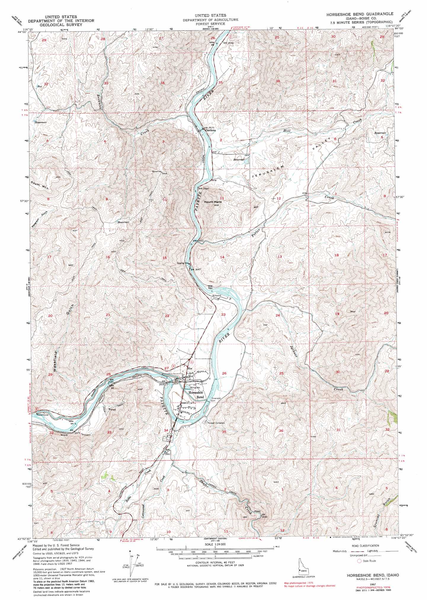
USGS Topo Quad 43116h2 - 1:24,000 scale
| Topo Map Name: | Horseshoe Bend |
| USGS Topo Quad ID: | 43116h2 |
| Print Size: | ca. 21 1/4" wide x 27" high |
| Southeast Coordinates: | 43.875° N latitude / 116.125° W longitude |
| Map Center Coordinates: | 43.9375° N latitude / 116.1875° W longitude |
| U.S. State: | ID |
| Filename: | o43116h2.jpg |
| Download Map JPG Image: | Horseshoe Bend topo map 1:24,000 scale |
| Map Type: | Topographic |
| Topo Series: | 7.5´ |
| Map Scale: | 1:24,000 |
| Source of Map Images: | United States Geological Survey (USGS) |
| Alternate Map Versions: |
Horseshoe Bend ID 1957, updated 1959 Download PDF Buy paper map Horseshoe Bend ID 1957, updated 1980 Download PDF Buy paper map Horseshoe Bend ID 1957, updated 1982 Download PDF Buy paper map Horseshoe Bend ID 1998, updated 2002 Download PDF Buy paper map Horseshoe Bend ID 2011 Download PDF Buy paper map Horseshoe Bend ID 2013 Download PDF Buy paper map |
1:24,000 Topo Quads surrounding Horseshoe Bend
Coonrod Gulch |
Ola |
High Valley |
Packer John Mountain |
Pyle Creek |
Squaw Butte |
Webb Creek |
Dry Buck Valley |
Banks |
Garden Valley |
Northeast Emmett |
Montour |
Horseshoe Bend |
Harris Creek Summit |
Placerville |
Southeast Emmett |
Pearl |
Cartwright Canyon |
Shafer Butte |
Warm Springs Point |
Star |
Eagle |
Boise North |
Robie Creek |
Dunnigan Creek |
> Back to 43116e1 at 1:100,000 scale
> Back to 43116a1 at 1:250,000 scale
> Back to U.S. Topo Maps home
Horseshoe Bend topo map: Gazetteer
Horseshoe Bend: Canals
Power Canal elevation 790m 2591′Horseshoe Bend: Populated Places
Gardena elevation 818m 2683′Horseshoe Bend elevation 802m 2631′
Horseshoe Bend: Streams
Brownlee Creek elevation 816m 2677′Cottonwood Creek elevation 805m 2641′
Hill Creek elevation 813m 2667′
Jackass Creek elevation 805m 2641′
Porter Creek elevation 811m 2660′
Robbs Creek elevation 798m 2618′
Shafer Creek elevation 791m 2595′
Horseshoe Bend: Summits
Mount Maria elevation 1039m 3408′Horseshoe Bend: Valleys
Jerusalem Valley elevation 826m 2709′Wakefield Gulch elevation 804m 2637′
Horseshoe Bend digital topo map on disk
Buy this Horseshoe Bend topo map showing relief, roads, GPS coordinates and other geographical features, as a high-resolution digital map file on DVD: