Hooker Creek Topo Map Oregon
To zoom in, hover over the map of Hooker Creek
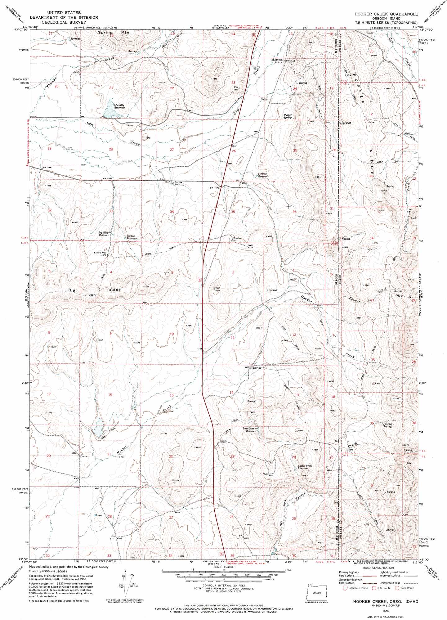
USGS Topo Quad 43117a1 - 1:24,000 scale
| Topo Map Name: | Hooker Creek |
| USGS Topo Quad ID: | 43117a1 |
| Print Size: | ca. 21 1/4" wide x 27" high |
| Southeast Coordinates: | 43° N latitude / 117° W longitude |
| Map Center Coordinates: | 43.0625° N latitude / 117.0625° W longitude |
| U.S. States: | OR, ID |
| Filename: | o43117a1.jpg |
| Download Map JPG Image: | Hooker Creek topo map 1:24,000 scale |
| Map Type: | Topographic |
| Topo Series: | 7.5´ |
| Map Scale: | 1:24,000 |
| Source of Map Images: | United States Geological Survey (USGS) |
| Alternate Map Versions: |
Hooker Creek OR 1969, updated 1973 Download PDF Buy paper map Hooker Creek OR 2011 Download PDF Buy paper map Hooker Creek OR 2014 Download PDF Buy paper map |
1:24,000 Topo Quads surrounding Hooker Creek
Rooster Comb |
Bannock Ridge |
Rockville |
Piute Butte |
Soldier Cap |
Mccain Creek |
Mahogany Gap |
Sheaville |
Captain Butte |
Rooster Comb Peak |
Cow Lakes |
Downey Canyon |
Hooker Creek |
Swisher Mountain |
De Lamar |
Danner |
Antelope Reservoir |
Jordan Valley |
Stonehouse Creek |
Flint |
Little Grassy Mountain |
Juniper Ridge |
Parsnip Peak |
Williams Creek |
Combination Ridge |
> Back to 43117a1 at 1:100,000 scale
> Back to 43116a1 at 1:250,000 scale
> Back to U.S. Topo Maps home
Hooker Creek topo map: Gazetteer
Hooker Creek: Dams
Cheyally Dam elevation 1372m 4501′Hooker Creek: Reservoirs
Barlow Reservoir elevation 1392m 4566′Baxter Creek Reservoir elevation 1415m 4642′
Big Ridge Reservoir elevation 1387m 4550′
Chevally Reservoir elevation 1371m 4498′
Hooker Reservoir elevation 1382m 4534′
Last Change Reservoir elevation 1410m 4625′
Stearns Reservoir elevation 1391m 4563′
Hooker Creek: Ridges
Big Ridge elevation 1461m 4793′Purser Ridge elevation 1527m 5009′
Purser Ridge elevation 1526m 5006′
Hooker Creek: Springs
Baxter Spring elevation 1367m 4484′Bennett Spring elevation 1464m 4803′
Cold Spring elevation 1378m 4520′
Jim Spring elevation 1385m 4543′
Poacher Spring elevation 1474m 4835′
Purser Spring elevation 1418m 4652′
Hooker Creek: Streams
Baxter Creek elevation 1387m 4550′Palmer Creek elevation 1397m 4583′
Palmer Creek elevation 1400m 4593′
Spring Branch elevation 1388m 4553′
Hooker Creek: Wells
Barlow Well elevation 1396m 4580′Hooker Creek digital topo map on disk
Buy this Hooker Creek topo map showing relief, roads, GPS coordinates and other geographical features, as a high-resolution digital map file on DVD: