Mccain Creek Topo Map Oregon
To zoom in, hover over the map of Mccain Creek
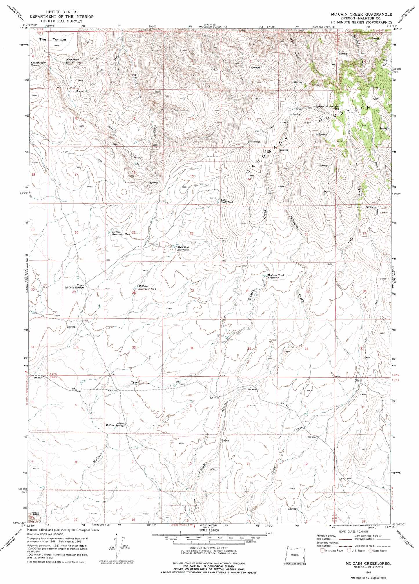
USGS Topo Quad 43117b3 - 1:24,000 scale
| Topo Map Name: | Mccain Creek |
| USGS Topo Quad ID: | 43117b3 |
| Print Size: | ca. 21 1/4" wide x 27" high |
| Southeast Coordinates: | 43.125° N latitude / 117.25° W longitude |
| Map Center Coordinates: | 43.1875° N latitude / 117.3125° W longitude |
| U.S. State: | OR |
| Filename: | o43117b3.jpg |
| Download Map JPG Image: | Mccain Creek topo map 1:24,000 scale |
| Map Type: | Topographic |
| Topo Series: | 7.5´ |
| Map Scale: | 1:24,000 |
| Source of Map Images: | United States Geological Survey (USGS) |
| Alternate Map Versions: |
Mc Cain Creek OR 1969, updated 1973 Download PDF Buy paper map McCain Creek OR 2011 Download PDF Buy paper map McCain Creek OR 2014 Download PDF Buy paper map |
1:24,000 Topo Quads surrounding Mccain Creek
Wall Rock Springs |
Quartz Mountain Basin |
Pelican Point |
Three Fingers Rock |
Pole Creek Top |
Big Mud Flat |
Diamond Butte |
Rooster Comb |
Bannock Ridge |
Rockville |
The Hole In The Ground |
Jordan Craters North |
Mccain Creek |
Mahogany Gap |
Sheaville |
Bogus Bench |
Jordan Craters South |
Cow Lakes |
Downey Canyon |
Hooker Creek |
Arock |
Threemile Hill |
Danner |
Antelope Reservoir |
Jordan Valley |
> Back to 43117a1 at 1:100,000 scale
> Back to 43116a1 at 1:250,000 scale
> Back to U.S. Topo Maps home
Mccain Creek topo map: Gazetteer
Mccain Creek: Gaps
Gunsight Pass elevation 1924m 6312′Mccain Creek: Reservoirs
Lake Shell Rock elevation 1559m 5114′McCain Creek Reservoir elevation 1520m 4986′
McCain Reservoir Number One elevation 1439m 4721′
McCain Reservoir Number Two elevation 1429m 4688′
Shell Rock Reservoir elevation 1468m 4816′
Mccain Creek: Springs
Grasshopper Spring elevation 1354m 4442′Lower McCain Springs elevation 1391m 4563′
Moonshine Spring elevation 1295m 4248′
Upper McCain Springs elevation 1410m 4625′
Mccain Creek: Summits
Mahogany Mountain elevation 1985m 6512′Mccain Creek digital topo map on disk
Buy this Mccain Creek topo map showing relief, roads, GPS coordinates and other geographical features, as a high-resolution digital map file on DVD: