Graveyard Point Topo Map Oregon
To zoom in, hover over the map of Graveyard Point
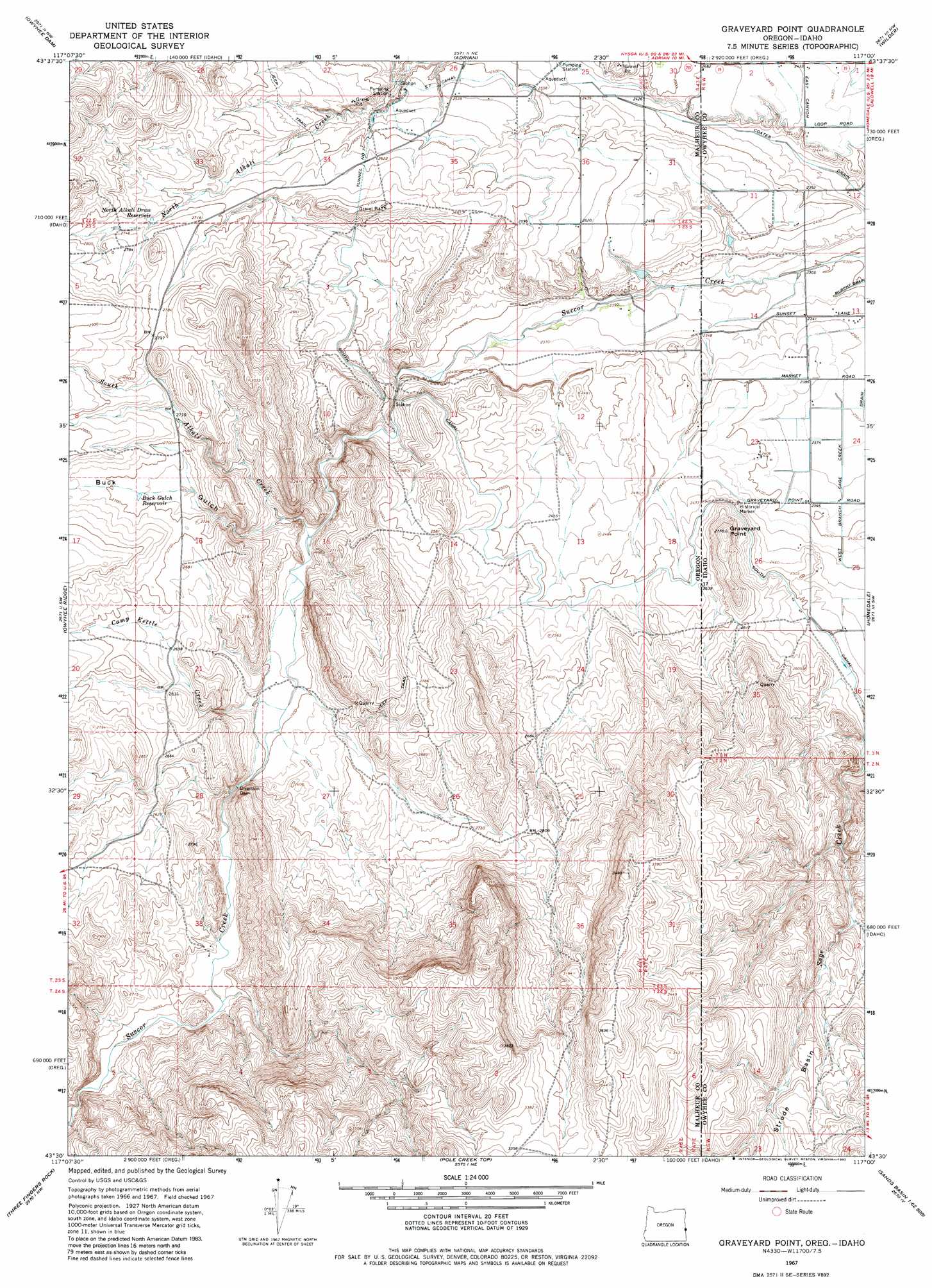
USGS Topo Quad 43117e1 - 1:24,000 scale
| Topo Map Name: | Graveyard Point |
| USGS Topo Quad ID: | 43117e1 |
| Print Size: | ca. 21 1/4" wide x 27" high |
| Southeast Coordinates: | 43.5° N latitude / 117° W longitude |
| Map Center Coordinates: | 43.5625° N latitude / 117.0625° W longitude |
| U.S. States: | OR, ID |
| Filename: | o43117e1.jpg |
| Download Map JPG Image: | Graveyard Point topo map 1:24,000 scale |
| Map Type: | Topographic |
| Topo Series: | 7.5´ |
| Map Scale: | 1:24,000 |
| Source of Map Images: | United States Geological Survey (USGS) |
| Alternate Map Versions: |
Graveyard Point ID 1967, updated 1970 Download PDF Buy paper map Graveyard Point ID 1967, updated 1982 Download PDF Buy paper map Graveyard Point ID 2011 Download PDF Buy paper map Graveyard Point ID 2013 Download PDF Buy paper map |
1:24,000 Topo Quads surrounding Graveyard Point
Double Mountain |
Mitchell Butte |
Owyhee |
Parma |
Parma Se |
Grassy Mountain |
Owyhee Dam |
Adrian |
Wilder |
Notus |
The Elbow |
Owyhee Ridge |
Graveyard Point |
Homedale |
Marsing |
Pelican Point |
Three Fingers Rock |
Pole Creek Top |
Jump Creek Canyon |
Opalene Gulch |
Rooster Comb |
Bannock Ridge |
Rockville |
Piute Butte |
Soldier Cap |
> Back to 43117e1 at 1:100,000 scale
> Back to 43116a1 at 1:250,000 scale
> Back to U.S. Topo Maps home
Graveyard Point topo map: Gazetteer
Graveyard Point: Areas
Agate Field elevation 795m 2608′Graveyard Point: Basins
Strode Basin elevation 943m 3093′Strode Basin elevation 924m 3031′
Graveyard Point: Canals
Bishop Ditch elevation 764m 2506′Coates Drain elevation 732m 2401′
Coates Drain elevation 714m 2342′
Five and Seventenths Canal elevation 770m 2526′
North Alkali Creek Siphon elevation 760m 2493′
Succor Creek Siphon elevation 769m 2522′
West Branch Sage Creek Drain elevation 720m 2362′
Graveyard Point: Cliffs
Graveyard Rim elevation 1050m 3444′Graveyard Point: Post Offices
Sucker Post Office (historical) elevation 717m 2352′Graveyard Point: Reservoirs
Ant Hill Reservoir elevation 781m 2562′Buck Gulch Reservoir elevation 818m 2683′
North Alkali Draw Reservoir elevation 826m 2709′
Shifting Sands Reservoir elevation 794m 2604′
Graveyard Point: Streams
Camp Kettle Creek elevation 757m 2483′South Alkali Creek elevation 744m 2440′
Graveyard Point: Summits
Graveyard Point elevation 845m 2772′Graveyard Point: Tunnels
Tunnel Number 7 elevation 804m 2637′Graveyard Point: Valleys
Buck Gulch elevation 758m 2486′Graveyard Point digital topo map on disk
Buy this Graveyard Point topo map showing relief, roads, GPS coordinates and other geographical features, as a high-resolution digital map file on DVD: