Shumway Reservoir Topo Map Oregon
To zoom in, hover over the map of Shumway Reservoir
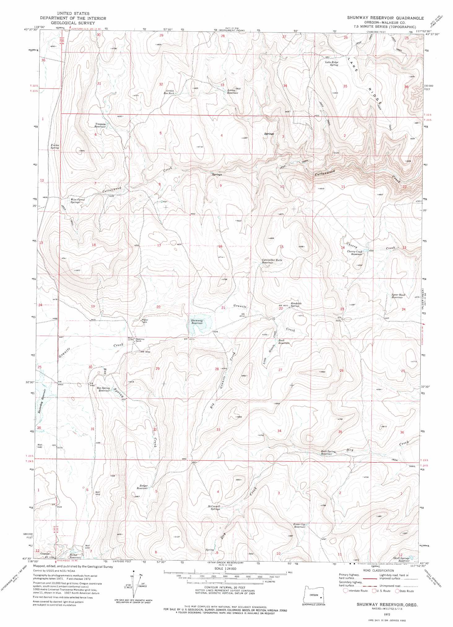
USGS Topo Quad 43117e8 - 1:24,000 scale
| Topo Map Name: | Shumway Reservoir |
| USGS Topo Quad ID: | 43117e8 |
| Print Size: | ca. 21 1/4" wide x 27" high |
| Southeast Coordinates: | 43.5° N latitude / 117.875° W longitude |
| Map Center Coordinates: | 43.5625° N latitude / 117.9375° W longitude |
| U.S. State: | OR |
| Filename: | o43117e8.jpg |
| Download Map JPG Image: | Shumway Reservoir topo map 1:24,000 scale |
| Map Type: | Topographic |
| Topo Series: | 7.5´ |
| Map Scale: | 1:24,000 |
| Source of Map Images: | United States Geological Survey (USGS) |
| Alternate Map Versions: |
Shumway Reservoir OR 1972, updated 1975 Download PDF Buy paper map Shumway Reservoir OR 2011 Download PDF Buy paper map Shumway Reservoir OR 2014 Download PDF Buy paper map |
1:24,000 Topo Quads surrounding Shumway Reservoir
Petes Mountain |
Stemler Ridge |
Jonesboro |
South Mountain |
Namorf |
Selle Gap |
Juntura |
Monument Peak |
Tims Peak |
Avery Creek |
Warm Springs Reservoir |
Mosquito Mountain |
Shumway Reservoir |
Alder Creek |
Rufino Butte |
Mcewen Butte |
Hickey Basin |
Star Creek Reservoir |
Skull Spring |
Copeland Reservoirs |
Venator Reservoir |
Stockade Mountain |
Crowley |
Burnt Flat |
Cedar Mountain |
> Back to 43117e1 at 1:100,000 scale
> Back to 43116a1 at 1:250,000 scale
> Back to U.S. Topo Maps home
Shumway Reservoir topo map: Gazetteer
Shumway Reservoir: Dams
Box Springs Dam elevation 1379m 4524′Shumway Dam elevation 1370m 4494′
Shumway Reservoir: Reservoirs
Arrien Reservoir elevation 1369m 4491′Arrien Reservoir Number Six elevation 1397m 4583′
Box Spring Reservoir elevation 1379m 4524′
Brass Cap Reservoir elevation 1448m 4750′
Buck Reservoir elevation 1424m 4671′
Caterpillar Butte Reservoir elevation 1425m 4675′
Cherry Creek Reservoir elevation 1359m 4458′
Dry Reservoir elevation 1379m 4524′
Rock Spring Reservoir elevation 1384m 4540′
Rodger Reservoir elevation 1448m 4750′
Sexton Reservoir elevation 1370m 4494′
Shumway Reservoir elevation 1373m 4504′
Skull Springs Reservoir elevation 1381m 4530′
Spear Head Reservoir elevation 1366m 4481′
Trespass Reservoir elevation 1397m 4583′
Shumway Reservoir: Springs
Fenton Spring elevation 1432m 4698′Lake Ridge Spring elevation 1474m 4835′
McConnell Springs elevation 1454m 4770′
Roadside Spring elevation 1418m 4652′
Wire Corral Springs elevation 1421m 4662′
Shumway Reservoir: Streams
Big Granite Creek elevation 1378m 4520′Box Spring Creek elevation 1364m 4475′
Little Granite Creek elevation 1403m 4603′
Shumway Reservoir digital topo map on disk
Buy this Shumway Reservoir topo map showing relief, roads, GPS coordinates and other geographical features, as a high-resolution digital map file on DVD: