Keeney Ridge Topo Map Oregon
To zoom in, hover over the map of Keeney Ridge
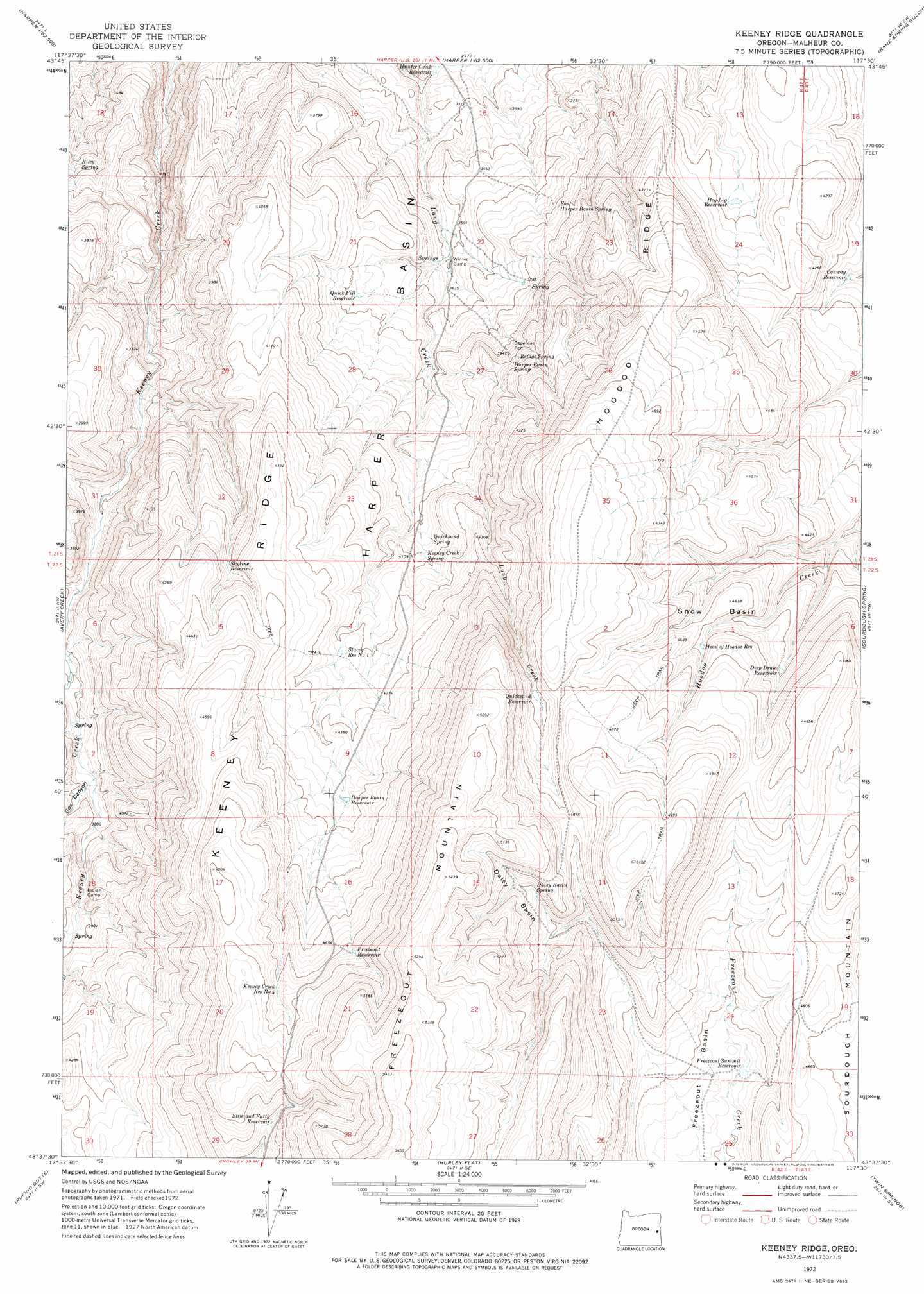
USGS Topo Quad 43117f5 - 1:24,000 scale
| Topo Map Name: | Keeney Ridge |
| USGS Topo Quad ID: | 43117f5 |
| Print Size: | ca. 21 1/4" wide x 27" high |
| Southeast Coordinates: | 43.625° N latitude / 117.5° W longitude |
| Map Center Coordinates: | 43.6875° N latitude / 117.5625° W longitude |
| U.S. State: | OR |
| Filename: | o43117f5.jpg |
| Download Map JPG Image: | Keeney Ridge topo map 1:24,000 scale |
| Map Type: | Topographic |
| Topo Series: | 7.5´ |
| Map Scale: | 1:24,000 |
| Source of Map Images: | United States Geological Survey (USGS) |
| Alternate Map Versions: |
Keeney Ridge OR 1972, updated 1975 Download PDF Buy paper map Keeney Ridge OR 2011 Download PDF Buy paper map Keeney Ridge OR 2014 Download PDF Buy paper map |
1:24,000 Topo Quads surrounding Keeney Ridge
Little Black Canyon |
Westfall |
Little Valley |
Vines Hill |
Vale West |
South Mountain |
Namorf |
Harper |
Kane Spring Gulch |
Double Mountain |
Tims Peak |
Avery Creek |
Keeney Ridge |
Sourdough Spring |
Grassy Mountain |
Alder Creek |
Rufino Butte |
Hurley Flat |
Twin Springs |
The Elbow |
Skull Spring |
Copeland Reservoirs |
Wall Rock Springs |
Quartz Mountain Basin |
Pelican Point |
> Back to 43117e1 at 1:100,000 scale
> Back to 43116a1 at 1:250,000 scale
> Back to U.S. Topo Maps home
Keeney Ridge topo map: Gazetteer
Keeney Ridge: Basins
Daisy Basin elevation 1465m 4806′Freezeout Basin elevation 1335m 4379′
Snow Basin elevation 1382m 4534′
Keeney Ridge: Reservoirs
Conway Reservoir elevation 1224m 4015′Deep Draw Reservoir elevation 1370m 4494′
Freezeout Reservoir elevation 1445m 4740′
Freezeout Summit Reservoir elevation 1322m 4337′
Harper Basin Reservoir elevation 1329m 4360′
Head of Hoodoo Reservoir elevation 1401m 4596′
Hog Leg Reservoir elevation 1243m 4078′
Hunter Creek Reservoir elevation 1041m 3415′
Keeney Creek Reservoir Number Four elevation 1444m 4737′
Quick Fill Reservoir elevation 1149m 3769′
Quicksand Reservoir elevation 1434m 4704′
Skyline Reservoir elevation 1283m 4209′
Slim and Fatty Reservoir elevation 1415m 4642′
Stacey Reservoir Number One elevation 1287m 4222′
Keeney Ridge: Ridges
Hoodoo Ridge elevation 1314m 4311′Keeney Ridge elevation 1464m 4803′
Keeney Ridge: Springs
Biley Spring elevation 1042m 3418′Daisy Basin Spring elevation 1460m 4790′
East Harper Basin Spring elevation 1168m 3832′
Harper Basin Spring elevation 1239m 4064′
Keeney Creek Spring elevation 1245m 4084′
Quicksand Spring elevation 1234m 4048′
Refuge Spring elevation 1233m 4045′
Keeney Ridge: Valleys
Box Canyon elevation 1143m 3750′Keeney Ridge digital topo map on disk
Buy this Keeney Ridge topo map showing relief, roads, GPS coordinates and other geographical features, as a high-resolution digital map file on DVD: