Stemler Ridge Topo Map Oregon
To zoom in, hover over the map of Stemler Ridge
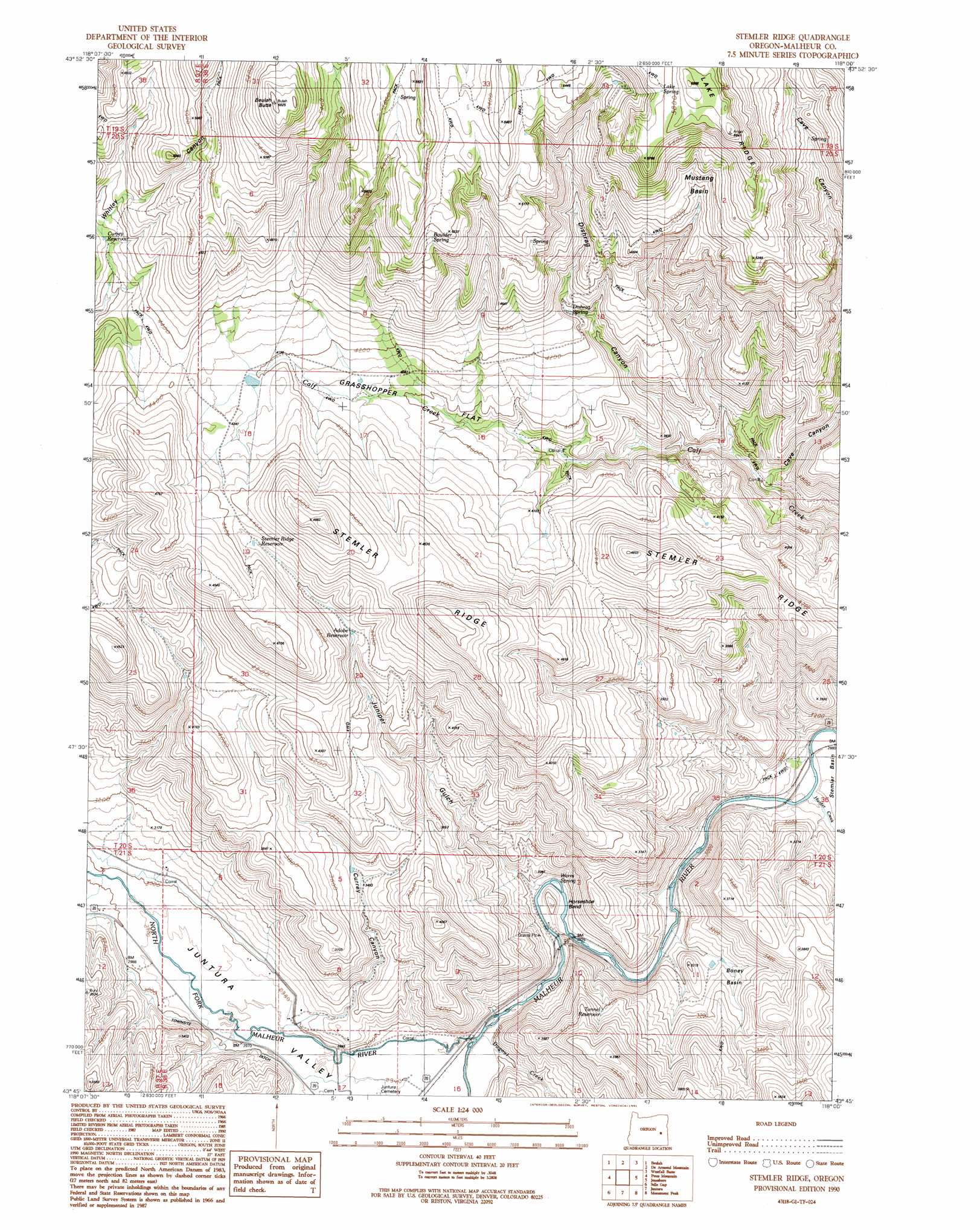
USGS Topo Quad 43118g1 - 1:24,000 scale
| Topo Map Name: | Stemler Ridge |
| USGS Topo Quad ID: | 43118g1 |
| Print Size: | ca. 21 1/4" wide x 27" high |
| Southeast Coordinates: | 43.75° N latitude / 118° W longitude |
| Map Center Coordinates: | 43.8125° N latitude / 118.0625° W longitude |
| U.S. State: | OR |
| Filename: | o43118g1.jpg |
| Download Map JPG Image: | Stemler Ridge topo map 1:24,000 scale |
| Map Type: | Topographic |
| Topo Series: | 7.5´ |
| Map Scale: | 1:24,000 |
| Source of Map Images: | United States Geological Survey (USGS) |
| Alternate Map Versions: |
Stemler Ridge OR 1990, updated 1991 Download PDF Buy paper map Stemler Ridge OR 2011 Download PDF Buy paper map Stemler Ridge OR 2014 Download PDF Buy paper map |
1:24,000 Topo Quads surrounding Stemler Ridge
Buck Trough Spring |
Castle Rock |
Hunter Mtn |
Little Juniper Spring |
Log Creek |
Cottonwood Reservoir |
Beulah |
De Armond Mountain |
Westfall Butte |
Little Black Canyon |
Drinkwater Pass |
Petes Mountain |
Stemler Ridge |
Jonesboro |
South Mountain |
Upton Mountain |
Selle Gap |
Juntura |
Monument Peak |
Tims Peak |
Warm Springs Creek |
Warm Springs Reservoir |
Mosquito Mountain |
Shumway Reservoir |
Alder Creek |
> Back to 43118e1 at 1:100,000 scale
> Back to 43118a1 at 1:250,000 scale
> Back to U.S. Topo Maps home
Stemler Ridge topo map: Gazetteer
Stemler Ridge: Basins
Boney Basin elevation 942m 3090′Mustang Basin elevation 1502m 4927′
Stemler Basin elevation 876m 2874′
Stemler Ridge: Bends
Horseshoe Bend elevation 930m 3051′Stemler Ridge: Bridges
Gwynn Bridge elevation 878m 2880′Horseshoe Bend Bridge elevation 893m 2929′
Stemler Ridge: Canals
Juntura Investment Company Canal elevation 942m 3090′Stemler Ridge: Flats
Grasshopper Flat elevation 1247m 4091′Stemler Ridge: Reservoirs
Adobe Reservoir elevation 1244m 4081′Beulah Creek Reservoir elevation 1276m 4186′
Boney Basin Reservoir elevation 924m 3031′
Calf Creek Waterhole elevation 1286m 4219′
Currey Canyon Reservoir elevation 928m 3044′
Dugout Reservoir elevation 1160m 3805′
Forest Reservoir elevation 1571m 5154′
Harris Reservoir elevation 1089m 3572′
Joyce Reservoir elevation 1221m 4005′
Stemler Ridge Reservoir elevation 1313m 4307′
Tunnel Reservoir elevation 1057m 3467′
Stemler Ridge: Ridges
Lake Ridge elevation 1806m 5925′Stemler Ridge elevation 1543m 5062′
Stemler Ridge: Springs
Boulder Spring elevation 1567m 5141′Boulder Spring Number 2 elevation 1477m 4845′
Dishrag Spring elevation 1284m 4212′
Horseshoe Bend Spring elevation 1046m 3431′
Lake Spring elevation 1759m 5770′
Poverty Spring elevation 1516m 4973′
Red Willow Spring elevation 1088m 3569′
Warm Spring elevation 887m 2910′
Stemler Ridge: Streams
Beulah Creek elevation 1243m 4078′Dugout Creek elevation 896m 2939′
Hunter Creek elevation 876m 2874′
North Fork Malheur River elevation 891m 2923′
Stemler Ridge: Summits
Beulah Butte elevation 1770m 5807′Stemler Ridge: Valleys
Cave Canyon elevation 1034m 3392′Currey Canyon elevation 928m 3044′
Dishrag Canyon elevation 1094m 3589′
Juniper Gulch elevation 892m 2926′
Juntura Valley elevation 891m 2923′
Stemler Ridge digital topo map on disk
Buy this Stemler Ridge topo map showing relief, roads, GPS coordinates and other geographical features, as a high-resolution digital map file on DVD: