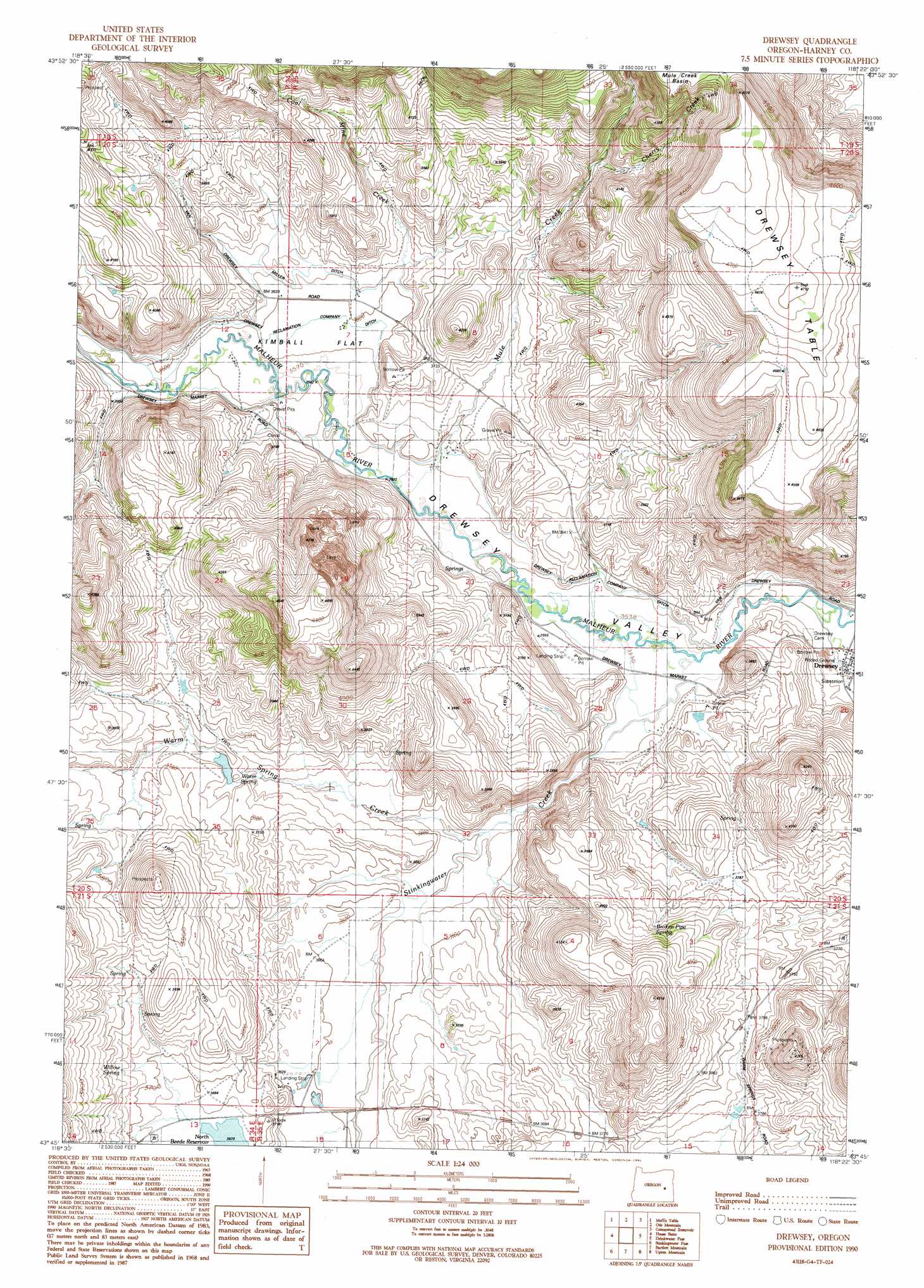
Drewsey Topo Map Oregon
To zoom in, hover over the map of Drewsey
USGS Topo Quad 43118g4 - 1:24,000 scale
| Topo Map Name: | Drewsey |
| USGS Topo Quad ID: | 43118g4 |
| Print Size: | ca. 21 1/4" wide x 27" high |
| Southeast Coordinates: | 43.75° N latitude / 118.375° W longitude |
| Map Center Coordinates: | 43.8125° N latitude / 118.4375° W longitude |
| U.S. State: | OR |
| Filename: | o43118g4.jpg |
| Download Map JPG Image: | Drewsey topo map 1:24,000 scale |
| Map Type: | Topographic |
| Topo Series: | 7.5´ |
| Map Scale: | 1:24,000 |
| Source of Map Images: | United States Geological Survey (USGS) |
| Alternate Map Versions: |
Drewsey OR 1990, updated 1991 Download PDF Buy paper map Drewsey OR 2011 Download PDF Buy paper map Drewsey OR 2014 Download PDF Buy paper map |
1:24,000 Topo Quads surrounding Drewsey
Magpie Table |
Dollar Basin |
Knox Mountain |
Buck Trough Spring |
Castle Rock |
Van |
Moffit Table |
Otis Mountain |
Cottonwood Reservoir |
Beulah |
Craft Point |
House Butte |
Drewsey |
Drinkwater Pass |
Petes Mountain |
Buchanan |
Stinkingwater Pass |
Bartlett Mountain |
Upton Mountain |
Selle Gap |
Carson Point |
Mahon Creek |
Coleman Mountain |
Warm Springs Creek |
Warm Springs Reservoir |
> Back to 43118e1 at 1:100,000 scale
> Back to 43118a1 at 1:250,000 scale
> Back to U.S. Topo Maps home
Drewsey topo map: Gazetteer
Drewsey: Canals
Drewsey Reclamation Company Ditch elevation 1089m 3572′Miller Ditch elevation 1104m 3622′
Sitz Ditch elevation 1112m 3648′
Drewsey: Dams
Sitz Dam elevation 1114m 3654′Drewsey: Flats
Kimball Flat elevation 1093m 3585′Drewsey: Populated Places
Drewsey elevation 1071m 3513′Drewsey: Post Offices
Drewsey Post Office elevation 1071m 3513′Drewsey: Springs
Broken Pipe Spring elevation 1182m 3877′Sheep Spring elevation 1134m 3720′
Warm Spring elevation 1119m 3671′
Willow Spring elevation 1141m 3743′
Drewsey: Streams
Cherry Creek elevation 1156m 3792′Coal Mine Creek elevation 1105m 3625′
Mule Creek elevation 1083m 3553′
Stinkingwater Creek elevation 1075m 3526′
Warm Spring Creek elevation 1085m 3559′
Drewsey: Summits
Drewsey Table elevation 1434m 4704′Drewsey digital topo map on disk
Buy this Drewsey topo map showing relief, roads, GPS coordinates and other geographical features, as a high-resolution digital map file on DVD: