Otis Mountain Topo Map Oregon
To zoom in, hover over the map of Otis Mountain
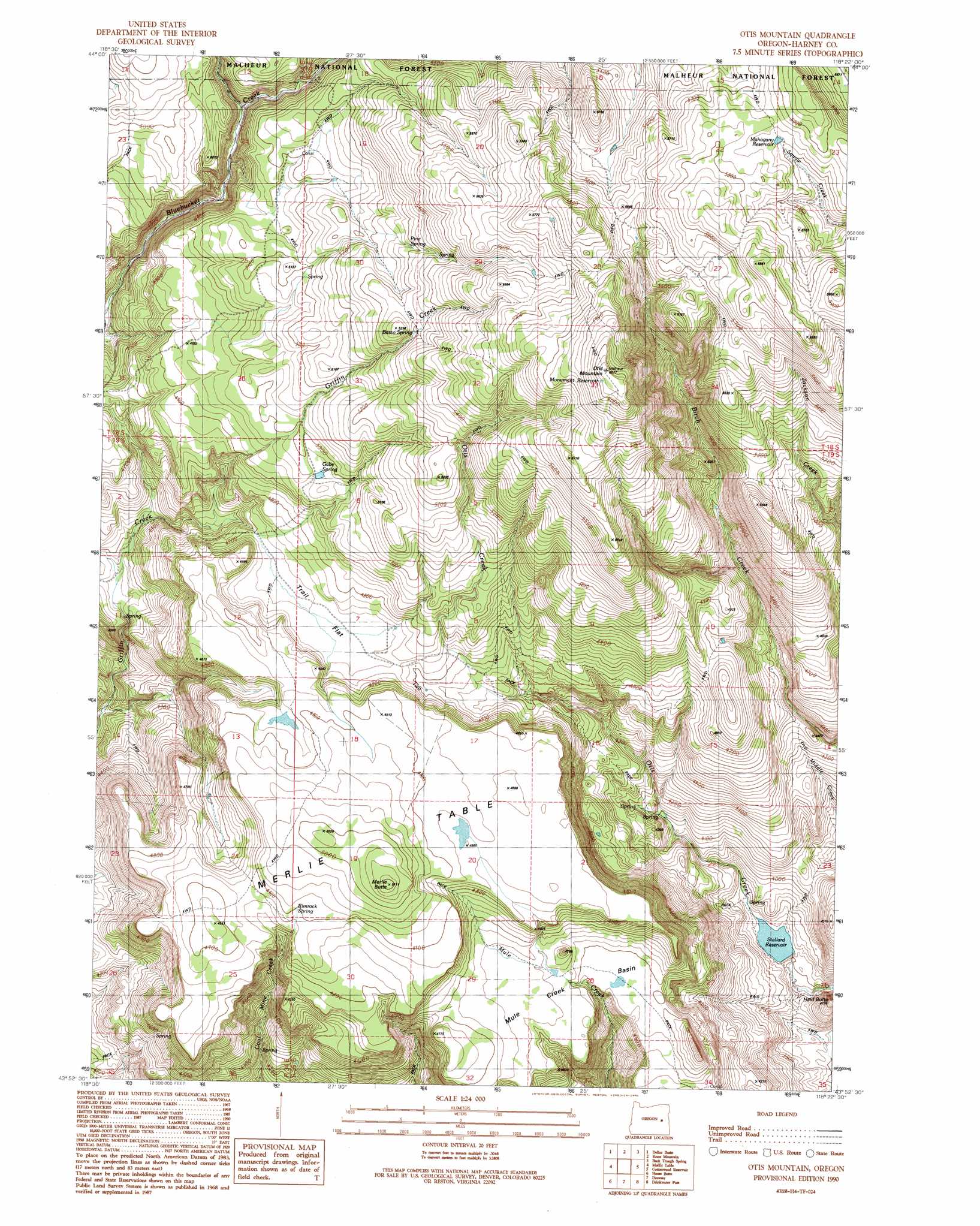
USGS Topo Quad 43118h4 - 1:24,000 scale
| Topo Map Name: | Otis Mountain |
| USGS Topo Quad ID: | 43118h4 |
| Print Size: | ca. 21 1/4" wide x 27" high |
| Southeast Coordinates: | 43.875° N latitude / 118.375° W longitude |
| Map Center Coordinates: | 43.9375° N latitude / 118.4375° W longitude |
| U.S. State: | OR |
| Filename: | o43118h4.jpg |
| Download Map JPG Image: | Otis Mountain topo map 1:24,000 scale |
| Map Type: | Topographic |
| Topo Series: | 7.5´ |
| Map Scale: | 1:24,000 |
| Source of Map Images: | United States Geological Survey (USGS) |
| Alternate Map Versions: |
Otis Mountain OR 1990, updated 1991 Download PDF Buy paper map Otis Mountain OR 1999, updated 2002 Download PDF Buy paper map Otis Mountain OR 2011 Download PDF Buy paper map Otis Mountain OR 2014 Download PDF Buy paper map |
| FStopo: | US Forest Service topo Otis Mountain is available: Download FStopo PDF Download FStopo TIF |
1:24,000 Topo Quads surrounding Otis Mountain
Logan Valley West |
Logan Valley East |
Crane Prairie |
Flag Prairie |
Clevenger Butte |
Magpie Table |
Dollar Basin |
Knox Mountain |
Buck Trough Spring |
Castle Rock |
Van |
Moffit Table |
Otis Mountain |
Cottonwood Reservoir |
Beulah |
Craft Point |
House Butte |
Drewsey |
Drinkwater Pass |
Petes Mountain |
Buchanan |
Stinkingwater Pass |
Bartlett Mountain |
Upton Mountain |
Selle Gap |
> Back to 43118e1 at 1:100,000 scale
> Back to 43118a1 at 1:250,000 scale
> Back to U.S. Topo Maps home
Otis Mountain topo map: Gazetteer
Otis Mountain: Basins
Mule Creek Basin elevation 1398m 4586′Otis Mountain: Dams
Stallard Dam elevation 1170m 3838′Otis Mountain: Flats
Trail Flat elevation 1442m 4730′Otis Mountain: Reservoirs
Mahogany Reservoir elevation 1747m 5731′Monument Reservoir elevation 1823m 5980′
Stallard Reservoir elevation 1170m 3838′
Otis Mountain: Springs
Basco Spring elevation 1620m 5314′Gabe Spring elevation 1515m 4970′
Pine Spring elevation 1612m 5288′
Rimrock Spring elevation 1495m 4904′
Otis Mountain: Summits
Hald Butte elevation 1147m 3763′Merlie Butte elevation 1558m 5111′
Merlie Table elevation 1512m 4960′
Otis Mountain elevation 1849m 6066′
Otis Mountain digital topo map on disk
Buy this Otis Mountain topo map showing relief, roads, GPS coordinates and other geographical features, as a high-resolution digital map file on DVD: