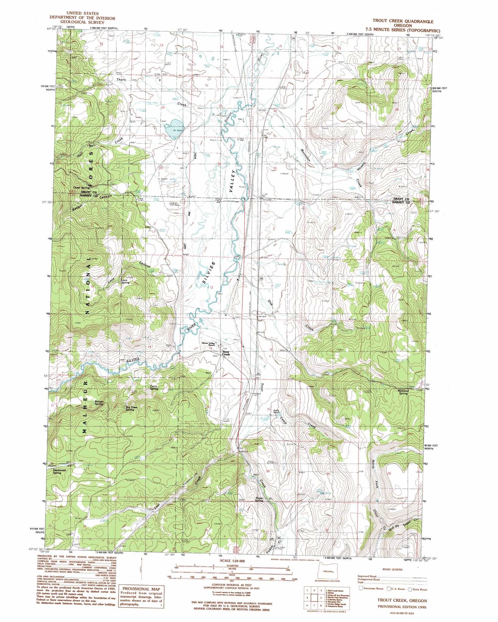
Trout Creek Topo Map Oregon
To zoom in, hover over the map of Trout Creek
USGS Topo Quad 43118h8 - 1:24,000 scale
| Topo Map Name: | Trout Creek |
| USGS Topo Quad ID: | 43118h8 |
| Print Size: | ca. 21 1/4" wide x 27" high |
| Southeast Coordinates: | 43.875° N latitude / 118.875° W longitude |
| Map Center Coordinates: | 43.9375° N latitude / 118.9375° W longitude |
| U.S. State: | OR |
| Filename: | o43118h8.jpg |
| Download Map JPG Image: | Trout Creek topo map 1:24,000 scale |
| Map Type: | Topographic |
| Topo Series: | 7.5´ |
| Map Scale: | 1:24,000 |
| Source of Map Images: | United States Geological Survey (USGS) |
| Alternate Map Versions: |
Trout Creek OR 1990, updated 1990 Download PDF Buy paper map Trout Creek OR 1999, updated 2002 Download PDF Buy paper map Trout Creek OR 2011 Download PDF Buy paper map Trout Creek OR 2014 Download PDF Buy paper map |
| FStopo: | US Forest Service topo Trout Creek is available: Download FStopo PDF Download FStopo TIF |
1:24,000 Topo Quads surrounding Trout Creek
Logdell |
Scotty Creek |
Seneca |
Big Canyon |
Logan Valley West |
Five Hundred Flat |
Rail Creek Butte |
Silvies |
Jumpoff Joe Mountain |
Magpie Table |
West Myrtle Butte |
Myrtle Park Meadows |
Trout Creek |
Calamity Butte |
Van |
Landing Creek |
Mosquito Flat |
Devine Ridge North |
Telephone Butte |
Craft Point |
Burns Ne |
Poison Creek |
Devine Ridge South |
Harney |
Buchanan |
> Back to 43118e1 at 1:100,000 scale
> Back to 43118a1 at 1:250,000 scale
> Back to U.S. Topo Maps home
Trout Creek topo map: Gazetteer
Trout Creek: Canals
West Side Ditch elevation 1388m 4553′Trout Creek: Dams
Buffalo Dam elevation 1392m 4566′Scheckels Dam elevation 1414m 4639′
Trout Creek: Lakes
Sherwood Lake elevation 1442m 4730′Trout Creek: Populated Places
Trout Creek elevation 1385m 4543′Trout Creek: Reservoirs
Buffalo Lake elevation 1392m 4566′Scheckels Reservoir elevation 1414m 4639′
Stekel Reservoir elevation 1455m 4773′
Trout Creek: Springs
Big Trees Spring elevation 1515m 4970′Curry Spring elevation 1433m 4701′
Deadwood Spring elevation 1550m 5085′
Loco Spring elevation 1527m 5009′
Log Pipe Spring elevation 1544m 5065′
Maitland Spring elevation 1596m 5236′
Owen Spring elevation 1484m 4868′
Ranger Spring elevation 1478m 4849′
Roper Spring elevation 1457m 4780′
Smith Spring elevation 1401m 4596′
Trout Creek: Streams
Camp Creek elevation 1396m 4580′Dog Creek elevation 1381m 4530′
Fuqua Creek elevation 1436m 4711′
Hall Creek elevation 1389m 4557′
Lost Creek elevation 1413m 4635′
Middle Fork Trout Creek elevation 1536m 5039′
Mountain Creek elevation 1413m 4635′
Newell Creek elevation 1387m 4550′
Thorn Creek elevation 1392m 4566′
Trout Creek elevation 1380m 4527′
Trout Creek: Valleys
Badger Canyon elevation 1389m 4557′Loco Canyon elevation 1387m 4550′
Silvies Valley elevation 1381m 4530′
Trout Creek digital topo map on disk
Buy this Trout Creek topo map showing relief, roads, GPS coordinates and other geographical features, as a high-resolution digital map file on DVD: