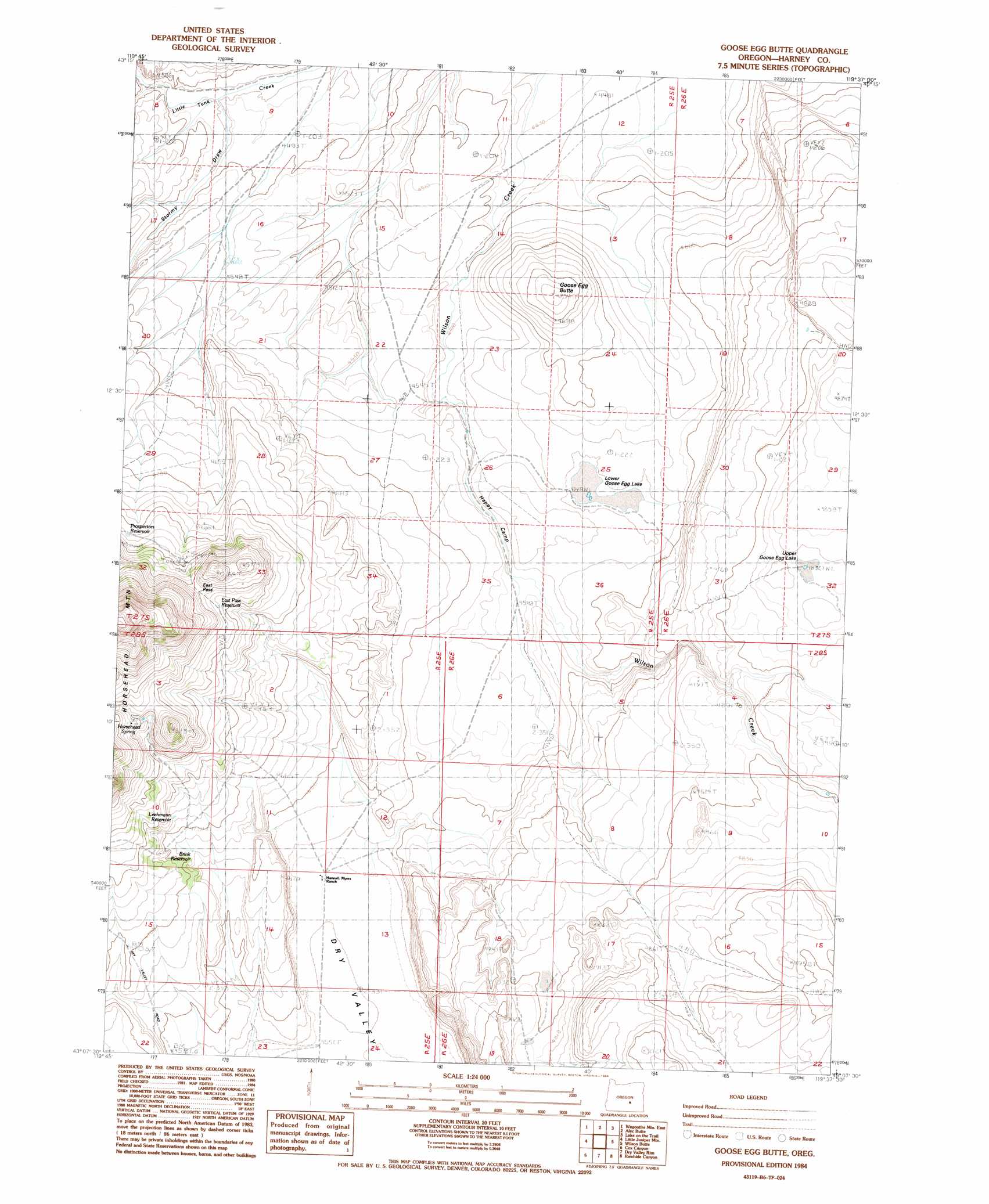
Goose Egg Butte Topo Map Oregon
To zoom in, hover over the map of Goose Egg Butte
USGS Topo Quad 43119b6 - 1:24,000 scale
| Topo Map Name: | Goose Egg Butte |
| USGS Topo Quad ID: | 43119b6 |
| Print Size: | ca. 21 1/4" wide x 27" high |
| Southeast Coordinates: | 43.125° N latitude / 119.625° W longitude |
| Map Center Coordinates: | 43.1875° N latitude / 119.6875° W longitude |
| U.S. State: | OR |
| Filename: | o43119b6.jpg |
| Download Map JPG Image: | Goose Egg Butte topo map 1:24,000 scale |
| Map Type: | Topographic |
| Topo Series: | 7.5´ |
| Map Scale: | 1:24,000 |
| Source of Map Images: | United States Geological Survey (USGS) |
| Alternate Map Versions: |
Goose Egg Butte OR 1984, updated 1984 Download PDF Buy paper map Goose Egg Butte OR 2011 Download PDF Buy paper map Goose Egg Butte OR 2014 Download PDF Buy paper map |
1:24,000 Topo Quads surrounding Goose Egg Butte
Round Top Butte |
Hay Lake |
Squaw Butte |
Capehart Lake |
Moon Reservoir |
Wagontire Mountain West |
Wagontire Mountain East |
Alec Butte |
Lake On The Trail |
Iron Mountain Flat |
Locust Butte |
Little Juniper Mountain |
Goose Egg Butte |
Wilson Butte |
Lunch Lake |
Venator Canyon |
Cox Canyon |
Dry Valley Rim |
Rawhide Canyon |
Flybee Lake |
Juniper Mountain |
Turpin Knoll |
Red Bank Lakes |
Rock Camp Draw |
Balls Lake |
> Back to 43119a1 at 1:100,000 scale
> Back to 43118a1 at 1:250,000 scale
> Back to U.S. Topo Maps home
Goose Egg Butte topo map: Gazetteer
Goose Egg Butte: Flats
Lower Goose Egg Lake elevation 1389m 4557′Goose Egg Butte: Gaps
East Pass elevation 1527m 5009′Goose Egg Butte: Lakes
Upper Goose Egg Lake elevation 1476m 4842′Goose Egg Butte: Mines
China Cap Mine elevation 1499m 4917′Goose Egg Butte: Reservoirs
Brink Reservoir elevation 1424m 4671′East Pass Reservoir elevation 1508m 4947′
Goose Egg Reservoir elevation 1462m 4796′
Leehmann Reservoir elevation 1445m 4740′
Lonely Reservoir elevation 1469m 4819′
Prospectors Reservoir elevation 1471m 4826′
Quarry Reservoir elevation 1493m 4898′
Goose Egg Butte: Springs
Horsehead Spring elevation 1543m 5062′Goose Egg Butte: Streams
Stormy Draw elevation 1366m 4481′Goose Egg Butte: Summits
Goose Egg Butte elevation 1450m 4757′Horsehead Mountain elevation 1585m 5200′
Goose Egg Butte: Valleys
Happy Camp elevation 1385m 4543′Little Tank Canyon elevation 1366m 4481′
Goose Egg Butte digital topo map on disk
Buy this Goose Egg Butte topo map showing relief, roads, GPS coordinates and other geographical features, as a high-resolution digital map file on DVD: