Iron Mountain Flat Topo Map Oregon
To zoom in, hover over the map of Iron Mountain Flat
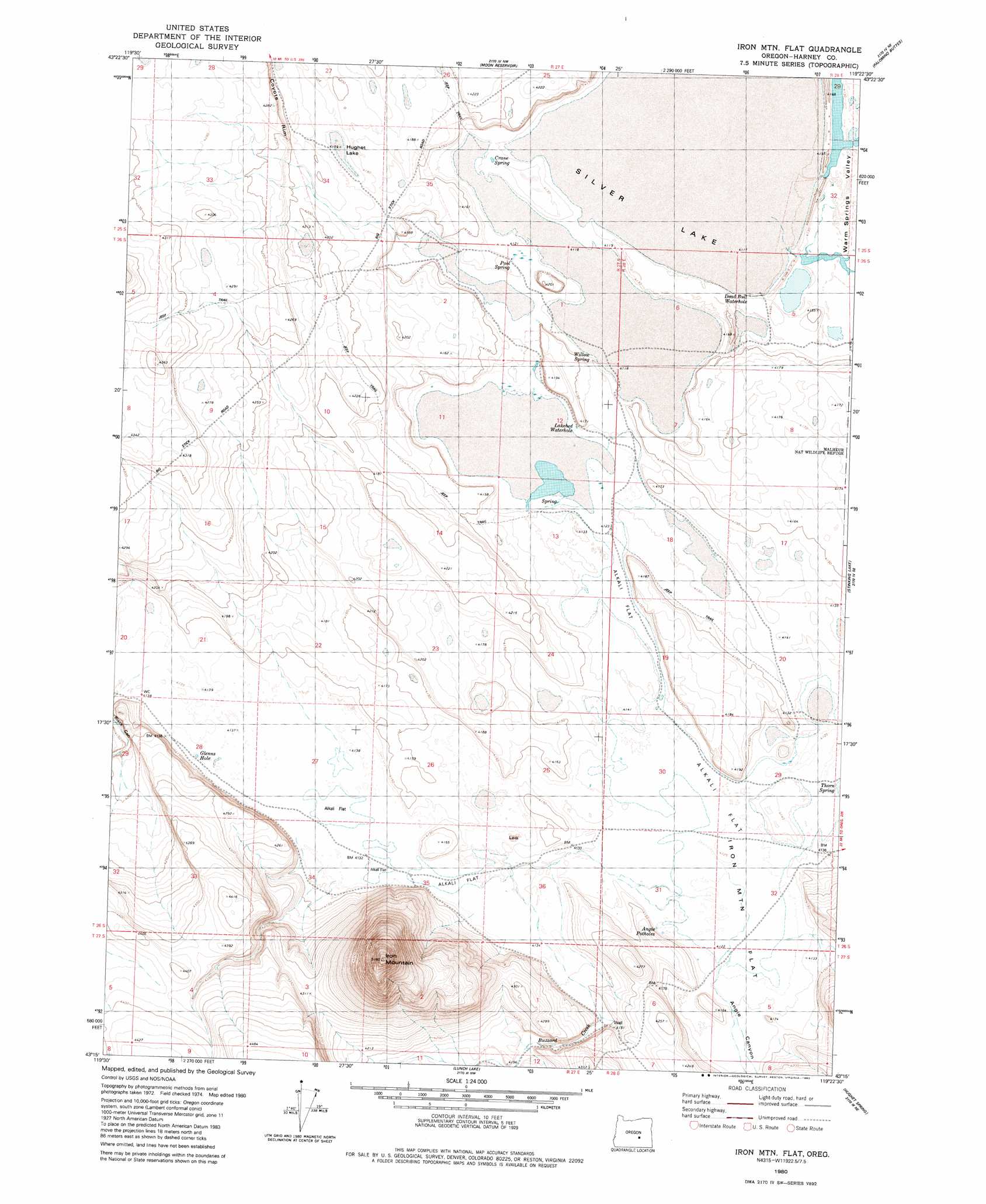
USGS Topo Quad 43119c4 - 1:24,000 scale
| Topo Map Name: | Iron Mountain Flat |
| USGS Topo Quad ID: | 43119c4 |
| Print Size: | ca. 21 1/4" wide x 27" high |
| Southeast Coordinates: | 43.25° N latitude / 119.375° W longitude |
| Map Center Coordinates: | 43.3125° N latitude / 119.4375° W longitude |
| U.S. State: | OR |
| Filename: | o43119c4.jpg |
| Download Map JPG Image: | Iron Mountain Flat topo map 1:24,000 scale |
| Map Type: | Topographic |
| Topo Series: | 7.5´ |
| Map Scale: | 1:24,000 |
| Source of Map Images: | United States Geological Survey (USGS) |
| Alternate Map Versions: |
Iron Mtn. Flat OR 1980, updated 1980 Download PDF Buy paper map Iron Mountain Flat OR 2011 Download PDF Buy paper map Iron Mountain Flat OR 2014 Download PDF Buy paper map |
1:24,000 Topo Quads surrounding Iron Mountain Flat
Suntex |
Riley |
Oakerman Lakes |
Sage Hen Hill |
Burns Butte |
Squaw Butte |
Capehart Lake |
Moon Reservoir |
Palomino Buttes |
Weaver Lake |
Alec Butte |
Lake On The Trail |
Iron Mountain Flat |
Stinking Lake |
Northwest Harney Lake |
Goose Egg Butte |
Wilson Butte |
Lunch Lake |
Hughet Spring |
Southwest Harney Lake |
Dry Valley Rim |
Rawhide Canyon |
Flybee Lake |
Meadow Lake |
Weed Lake Butte |
> Back to 43119a1 at 1:100,000 scale
> Back to 43118a1 at 1:250,000 scale
> Back to U.S. Topo Maps home
Iron Mountain Flat topo map: Gazetteer
Iron Mountain Flat: Flats
Iron Mountain Flat elevation 1258m 4127′Silver Lake elevation 1256m 4120′
Iron Mountain Flat: Lakes
Angie Potholes elevation 1259m 4130′Deadbull Waterhole elevation 1261m 4137′
Glenns Hole elevation 1262m 4140′
Hughet Lake elevation 1271m 4169′
Lakebed Waterhole elevation 1260m 4133′
Iron Mountain Flat: Springs
Crane Spring elevation 1258m 4127′Pool Spring elevation 1259m 4130′
Thorn Spring elevation 1256m 4120′
Willow Spring elevation 1257m 4124′
Iron Mountain Flat: Streams
Big Stick Creek elevation 1262m 4140′Buzzard Creek elevation 1258m 4127′
Iron Mountain Flat: Summits
Iron Mountain elevation 1637m 5370′Iron Mountain Flat: Valleys
Angie Canyon elevation 1259m 4130′Buzzard Canyon elevation 1261m 4137′
Iron Mountain Flat digital topo map on disk
Buy this Iron Mountain Flat topo map showing relief, roads, GPS coordinates and other geographical features, as a high-resolution digital map file on DVD: