Mosquito Flat Topo Map Oregon
To zoom in, hover over the map of Mosquito Flat
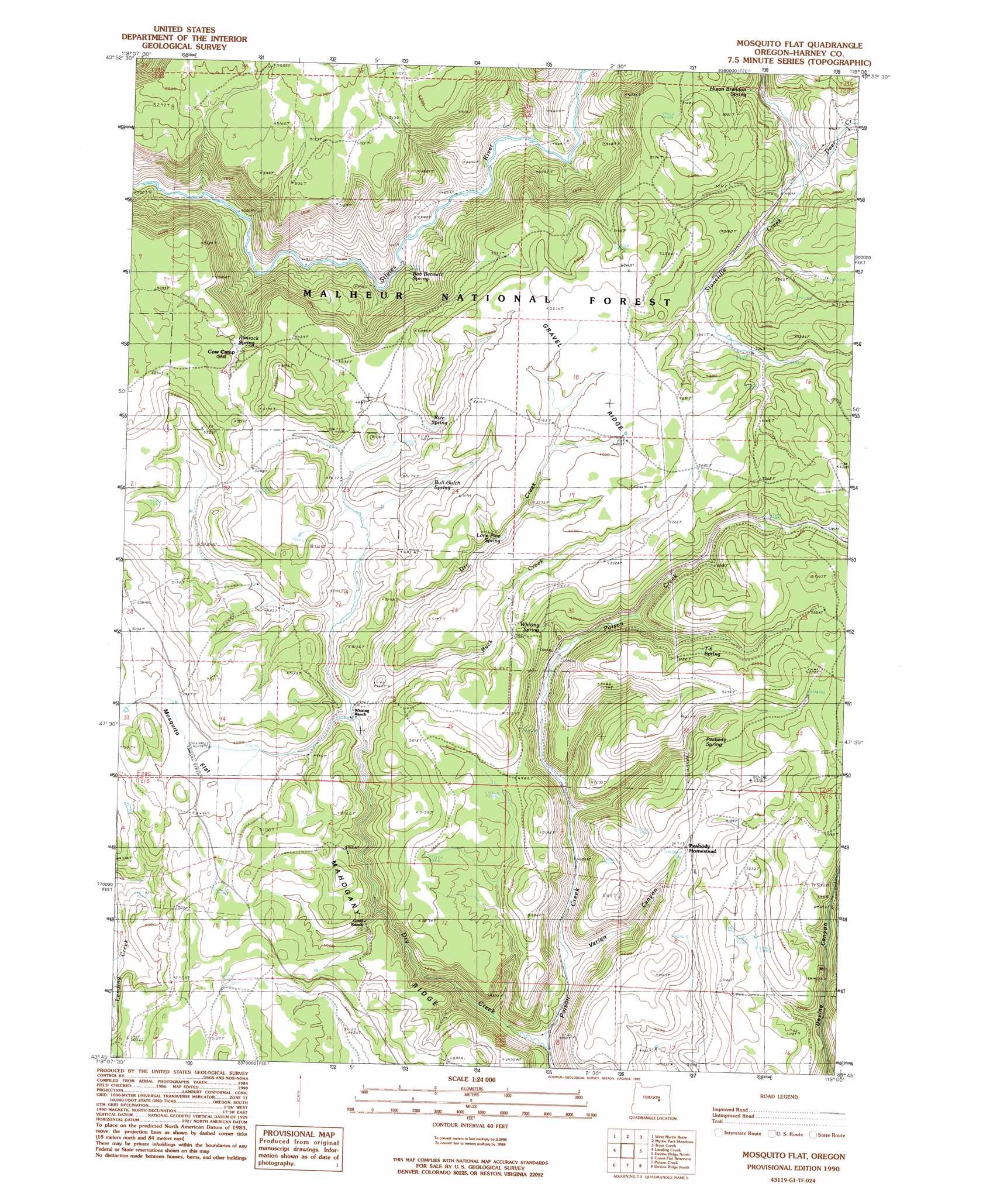
USGS Topo Quad 43119g1 - 1:24,000 scale
| Topo Map Name: | Mosquito Flat |
| USGS Topo Quad ID: | 43119g1 |
| Print Size: | ca. 21 1/4" wide x 27" high |
| Southeast Coordinates: | 43.75° N latitude / 119° W longitude |
| Map Center Coordinates: | 43.8125° N latitude / 119.0625° W longitude |
| U.S. State: | OR |
| Filename: | o43119g1.jpg |
| Download Map JPG Image: | Mosquito Flat topo map 1:24,000 scale |
| Map Type: | Topographic |
| Topo Series: | 7.5´ |
| Map Scale: | 1:24,000 |
| Source of Map Images: | United States Geological Survey (USGS) |
| Alternate Map Versions: |
Mosquito Flat OR 1990, updated 1999 Download PDF Buy paper map Mosquito Flat OR 1999, updated 2002 Download PDF Buy paper map Mosquito Flat OR 2011 Download PDF Buy paper map Mosquito Flat OR 2014 Download PDF Buy paper map |
| FStopo: | US Forest Service topo Mosquito Flat is available: Download FStopo PDF Download FStopo TIF |
1:24,000 Topo Quads surrounding Mosquito Flat
Lewis Creek |
Five Hundred Flat |
Rail Creek Butte |
Silvies |
Jumpoff Joe Mountain |
Alsup Mountain |
West Myrtle Butte |
Myrtle Park Meadows |
Trout Creek |
Calamity Butte |
Hughet Valley |
Landing Creek |
Mosquito Flat |
Devine Ridge North |
Telephone Butte |
Holmes Canyon |
Burns Ne |
Poison Creek |
Devine Ridge South |
Harney |
Sage Hen Hill |
Burns Butte |
Burns |
Poison Creek Slough |
Ninemile Slough |
> Back to 43119e1 at 1:100,000 scale
> Back to 43118a1 at 1:250,000 scale
> Back to U.S. Topo Maps home
Mosquito Flat topo map: Gazetteer
Mosquito Flat: Flats
Mosquito Flat elevation 1519m 4983′Mosquito Flat: Parks
Devine Monument elevation 1559m 5114′Mosquito Flat: Ridges
Gravel Ridge elevation 1598m 5242′Mahogany Ridge elevation 1504m 4934′
Mosquito Flat: Springs
Baker Spring elevation 1546m 5072′Bob Bennett Spring elevation 1395m 4576′
Bull Gulch Spring elevation 1536m 5039′
Hixon Brandon Spring elevation 1561m 5121′
Landing Creek Spring elevation 1500m 4921′
Lone Pine Spring elevation 1534m 5032′
Peabody Spring elevation 1544m 5065′
Rice Spring elevation 1537m 5042′
Rimrock Spring elevation 1521m 4990′
T-6 Spring elevation 1560m 5118′
Whiting Spring elevation 1530m 5019′
Mosquito Flat: Streams
Buck Creek elevation 1492m 4895′Deer Creek elevation 1481m 4858′
Dry Creek elevation 1376m 4514′
Mosquito Flat: Valleys
Varien Canyon elevation 1402m 4599′Mosquito Flat digital topo map on disk
Buy this Mosquito Flat topo map showing relief, roads, GPS coordinates and other geographical features, as a high-resolution digital map file on DVD: