Landing Creek Topo Map Oregon
To zoom in, hover over the map of Landing Creek
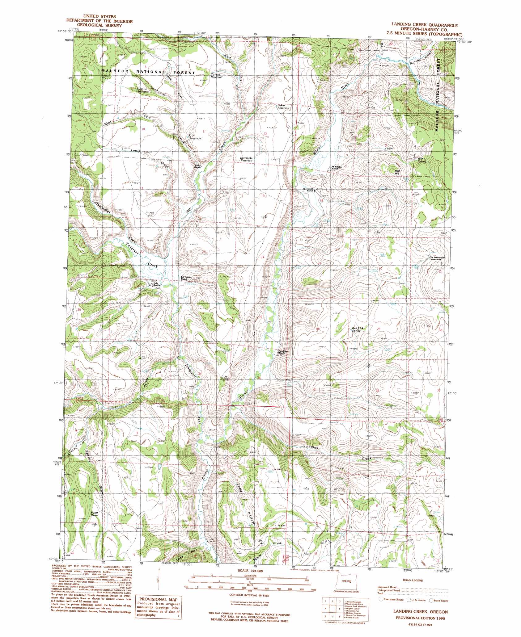
USGS Topo Quad 43119g2 - 1:24,000 scale
| Topo Map Name: | Landing Creek |
| USGS Topo Quad ID: | 43119g2 |
| Print Size: | ca. 21 1/4" wide x 27" high |
| Southeast Coordinates: | 43.75° N latitude / 119.125° W longitude |
| Map Center Coordinates: | 43.8125° N latitude / 119.1875° W longitude |
| U.S. State: | OR |
| Filename: | o43119g2.jpg |
| Download Map JPG Image: | Landing Creek topo map 1:24,000 scale |
| Map Type: | Topographic |
| Topo Series: | 7.5´ |
| Map Scale: | 1:24,000 |
| Source of Map Images: | United States Geological Survey (USGS) |
| Alternate Map Versions: |
Landing Creek OR 1990, updated 1990 Download PDF Buy paper map Landing Creek OR 1999, updated 2002 Download PDF Buy paper map Landing Creek OR 2011 Download PDF Buy paper map Landing Creek OR 2014 Download PDF Buy paper map |
| FStopo: | US Forest Service topo Landing Creek is available: Download FStopo PDF Download FStopo TIF |
1:24,000 Topo Quads surrounding Landing Creek
Izee |
Lewis Creek |
Five Hundred Flat |
Rail Creek Butte |
Silvies |
Whiskey Mountain |
Alsup Mountain |
West Myrtle Butte |
Myrtle Park Meadows |
Trout Creek |
Bear Canyon Butte |
Hughet Valley |
Landing Creek |
Mosquito Flat |
Devine Ridge North |
Egypt Canyon |
Holmes Canyon |
Burns Ne |
Poison Creek |
Devine Ridge South |
Oakerman Lakes |
Sage Hen Hill |
Burns Butte |
Burns |
Poison Creek Slough |
> Back to 43119e1 at 1:100,000 scale
> Back to 43118a1 at 1:250,000 scale
> Back to U.S. Topo Maps home
Landing Creek topo map: Gazetteer
Landing Creek: Basins
Burnt Basin elevation 1494m 4901′Landing Creek: Reservoirs
Baker Reservoir elevation 1401m 4596′C 7 Reservoir elevation 1355m 4445′
Cullens Reservoir elevation 1384m 4540′
Larraneta Reservoir elevation 1372m 4501′
Landing Creek: Springs
Baker Spring elevation 1392m 4566′Granite Spring elevation 1400m 4593′
Hunter Camp Seep elevation 1490m 4888′
R D Spring elevation 1435m 4708′
Red Lick Spring elevation 1480m 4855′
Landing Creek: Streams
Deadwood Creek elevation 1313m 4307′Dry Creek elevation 1324m 4343′
Emigrant Creek elevation 1289m 4229′
Hay Creek elevation 1303m 4274′
Lake Creek elevation 1291m 4235′
Landing Creek elevation 1293m 4242′
Lewis Creek elevation 1307m 4288′
Myrtle Creek elevation 1329m 4360′
North Fork Deadwood Creek elevation 1356m 4448′
Skull Creek elevation 1295m 4248′
Slickear Creek elevation 1359m 4458′
West Fork Deadwood Creek elevation 1349m 4425′
West Fork Hay Creek elevation 1335m 4379′
Yellowjacket Creek elevation 1304m 4278′
Landing Creek: Summits
Red Hill elevation 1489m 4885′Landing Creek: Valleys
Finke Draw elevation 1316m 4317′Long Hollow elevation 1288m 4225′
Spring Draw elevation 1402m 4599′
Landing Creek digital topo map on disk
Buy this Landing Creek topo map showing relief, roads, GPS coordinates and other geographical features, as a high-resolution digital map file on DVD: