West Myrtle Butte Topo Map Oregon
To zoom in, hover over the map of West Myrtle Butte
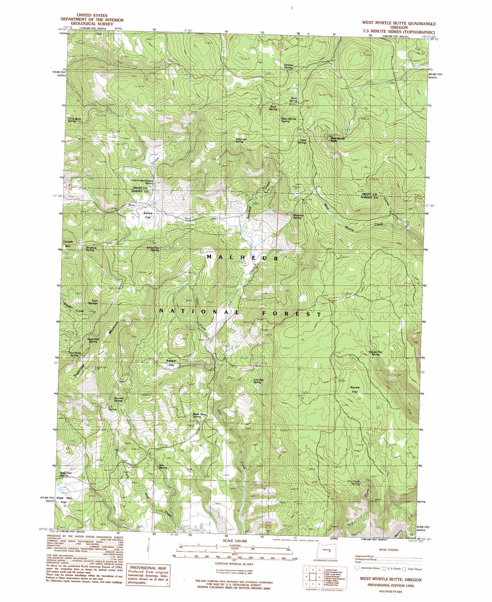
USGS Topo Quad 43119h2 - 1:24,000 scale
| Topo Map Name: | West Myrtle Butte |
| USGS Topo Quad ID: | 43119h2 |
| Print Size: | ca. 21 1/4" wide x 27" high |
| Southeast Coordinates: | 43.875° N latitude / 119.125° W longitude |
| Map Center Coordinates: | 43.9375° N latitude / 119.1875° W longitude |
| U.S. State: | OR |
| Filename: | o43119h2.jpg |
| Download Map JPG Image: | West Myrtle Butte topo map 1:24,000 scale |
| Map Type: | Topographic |
| Topo Series: | 7.5´ |
| Map Scale: | 1:24,000 |
| Source of Map Images: | United States Geological Survey (USGS) |
| Alternate Map Versions: |
West Myrtle Butte OR 1990, updated 1990 Download PDF Buy paper map West Myrtle Butte OR 1999, updated 2002 Download PDF Buy paper map West Myrtle Butte OR 2011 Download PDF Buy paper map West Myrtle Butte OR 2014 Download PDF Buy paper map |
| FStopo: | US Forest Service topo West Myrtle Butte is available: Download FStopo PDF Download FStopo TIF |
1:24,000 Topo Quads surrounding West Myrtle Butte
Graylock Butte |
Flagtail Mountain |
Logdell |
Scotty Creek |
Seneca |
Izee |
Lewis Creek |
Five Hundred Flat |
Rail Creek Butte |
Silvies |
Whiskey Mountain |
Alsup Mountain |
West Myrtle Butte |
Myrtle Park Meadows |
Trout Creek |
Bear Canyon Butte |
Hughet Valley |
Landing Creek |
Mosquito Flat |
Devine Ridge North |
Egypt Canyon |
Holmes Canyon |
Burns Ne |
Poison Creek |
Devine Ridge South |
> Back to 43119e1 at 1:100,000 scale
> Back to 43118a1 at 1:250,000 scale
> Back to U.S. Topo Maps home
West Myrtle Butte topo map: Gazetteer
West Myrtle Butte: Flats
Badger Flat elevation 1525m 5003′Sallys Flat elevation 1590m 5216′
Squaw Flat elevation 1667m 5469′
West Myrtle Butte: Springs
Bingham Spring elevation 1683m 5521′Black Snag Spring elevation 1488m 4881′
Brad Spring elevation 1815m 5954′
Cold Spring elevation 1807m 5928′
Deer Spring elevation 1685m 5528′
Dry Creek Spring elevation 1622m 5321′
Gribble Spring elevation 1811m 5941′
Hole-in-the-Ground Spring elevation 1611m 5285′
Izee Spring elevation 1450m 4757′
J T Spring elevation 1647m 5403′
Link Bar Spring elevation 1563m 5127′
Mud Spring elevation 1776m 5826′
Rainbow Spring elevation 1661m 5449′
Robinson Spring elevation 1843m 6046′
Sallys Flat Spring elevation 1649m 5410′
Soup Spring elevation 1792m 5879′
Squaw Flat Spring elevation 1705m 5593′
Sugarloaf Spring elevation 1717m 5633′
Summit Spring elevation 1602m 5255′
Thornburg Spring elevation 1655m 5429′
Tipton Spring elevation 1756m 5761′
Twin Springs elevation 1715m 5626′
West Myrtle Spring elevation 1845m 6053′
West Myrtle Butte: Streams
Alder Creek elevation 1501m 4924′Cooley Creek elevation 1666m 5465′
Rainbow Creek elevation 1551m 5088′
West Myrtle Butte: Summits
Sugarloaf Mountain elevation 1860m 6102′West Myrtle Butte elevation 1907m 6256′
West Myrtle Butte digital topo map on disk
Buy this West Myrtle Butte topo map showing relief, roads, GPS coordinates and other geographical features, as a high-resolution digital map file on DVD: