Big Mowich Mountain Topo Map Oregon
To zoom in, hover over the map of Big Mowich Mountain
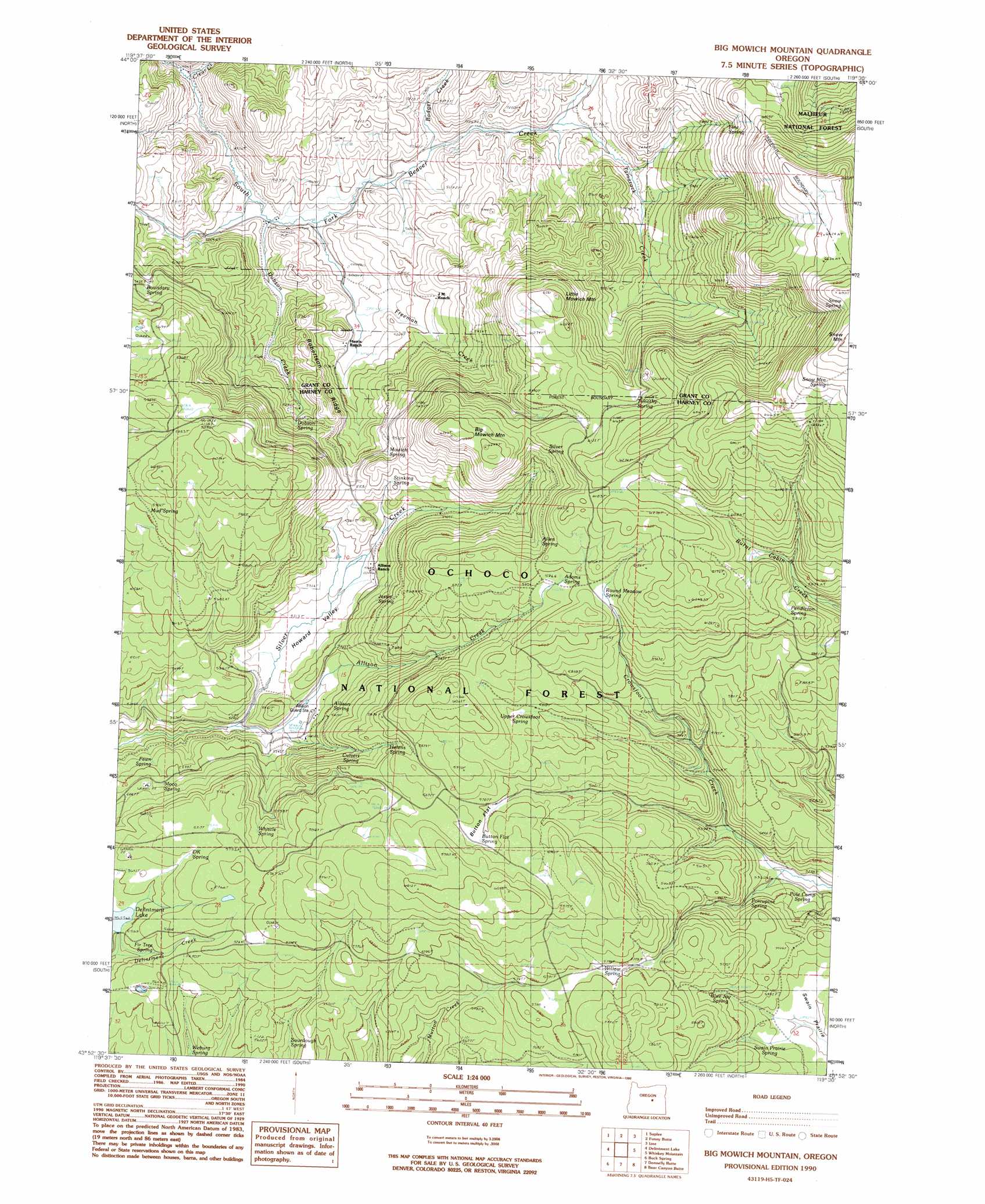
USGS Topo Quad 43119h5 - 1:24,000 scale
| Topo Map Name: | Big Mowich Mountain |
| USGS Topo Quad ID: | 43119h5 |
| Print Size: | ca. 21 1/4" wide x 27" high |
| Southeast Coordinates: | 43.875° N latitude / 119.5° W longitude |
| Map Center Coordinates: | 43.9375° N latitude / 119.5625° W longitude |
| U.S. State: | OR |
| Filename: | o43119h5.jpg |
| Download Map JPG Image: | Big Mowich Mountain topo map 1:24,000 scale |
| Map Type: | Topographic |
| Topo Series: | 7.5´ |
| Map Scale: | 1:24,000 |
| Source of Map Images: | United States Geological Survey (USGS) |
| Alternate Map Versions: |
Big Mowich Mountain OR 1990, updated 1990 Download PDF Buy paper map Big Mowich Mountain OR 1992, updated 1997 Download PDF Buy paper map Big Mowich Mountain OR 2011 Download PDF Buy paper map Big Mowich Mountain OR 2014 Download PDF Buy paper map |
| FStopo: | US Forest Service topo Big Mowich Mountain is available: Download FStopo PDF Download FStopo TIF |
1:24,000 Topo Quads surrounding Big Mowich Mountain
Mud Spring |
Powell Mountain |
Suplee Butte |
Graylock Butte |
Flagtail Mountain |
Angell Butte |
Suplee |
Funny Butte |
Izee |
Lewis Creek |
Twelvemile Reservoir |
Delintment Lake |
Big Mowich Mountain |
Whiskey Mountain |
Alsup Mountain |
Mackey Butte |
Buck Spring |
Donnelly Butte |
Bear Canyon Butte |
Hughet Valley |
Bulger Ridge |
Camp Currey Spring |
Dry Mountain |
Egypt Canyon |
Holmes Canyon |
> Back to 43119e1 at 1:100,000 scale
> Back to 43118a1 at 1:250,000 scale
> Back to U.S. Topo Maps home
Big Mowich Mountain topo map: Gazetteer
Big Mowich Mountain: Dams
Delintment Lake Dam elevation 1700m 5577′Big Mowich Mountain: Flats
Button Flat elevation 1747m 5731′Lehman Meadow elevation 1895m 6217′
Big Mowich Mountain: Lakes
Delintment Lake elevation 1700m 5577′Big Mowich Mountain: Reservoirs
Beaver Reservoir elevation 1583m 5193′Big Mowich Mountain: Ridges
Robertson Ridge elevation 1615m 5298′Big Mowich Mountain: Springs
Adams Spring elevation 1827m 5994′Allen Spring elevation 1780m 5839′
Allison Spring elevation 1631m 5351′
Blue Jay Spring elevation 1706m 5597′
Button Flat Spring elevation 1778m 5833′
Culvert Spring elevation 1702m 5583′
DK Spring elevation 1717m 5633′
Dobson Spring elevation 1690m 5544′
Fawn Spring elevation 1630m 5347′
Fine Spring elevation 1752m 5748′
Fir Tree Spring elevation 1698m 5570′
Helens Spring elevation 1758m 5767′
Jessie Spring elevation 1651m 5416′
Moco Spring elevation 1657m 5436′
Mowich Spring elevation 1653m 5423′
Mud Spring elevation 1765m 5790′
Pendleton Spring elevation 1808m 5931′
Pole Camp Spring elevation 1618m 5308′
Porcupine Spring elevation 1644m 5393′
Round Meadow Spring elevation 1835m 6020′
Silver Spring elevation 1835m 6020′
Snow Mountain Spring elevation 2076m 6811′
Snow Spring elevation 2084m 6837′
Sourdough Spring elevation 1687m 5534′
Stinking Spring elevation 1711m 5613′
Swain Prairie Spring elevation 1700m 5577′
Timothy Spring elevation 1853m 6079′
Upper Crowsfoot Spring elevation 1779m 5836′
Weburg Spring elevation 1698m 5570′
Whistle Spring elevation 1735m 5692′
Willow Spring elevation 1761m 5777′
Big Mowich Mountain: Streams
Allison Creek elevation 1592m 5223′Clear Creek elevation 1538m 5045′
Dobson Creek elevation 1518m 4980′
Freeman Creek elevation 1509m 4950′
Tamarack Creek elevation 1563m 5127′
Whistle Creek elevation 1612m 5288′
Big Mowich Mountain: Summits
Big Mowich Mountain elevation 1878m 6161′Little Mowich Mountain elevation 1914m 6279′
Big Mowich Mountain: Valleys
Howard Valley elevation 1622m 5321′Big Mowich Mountain digital topo map on disk
Buy this Big Mowich Mountain topo map showing relief, roads, GPS coordinates and other geographical features, as a high-resolution digital map file on DVD: