Saint Patrick Mountain Topo Map Oregon
To zoom in, hover over the map of Saint Patrick Mountain
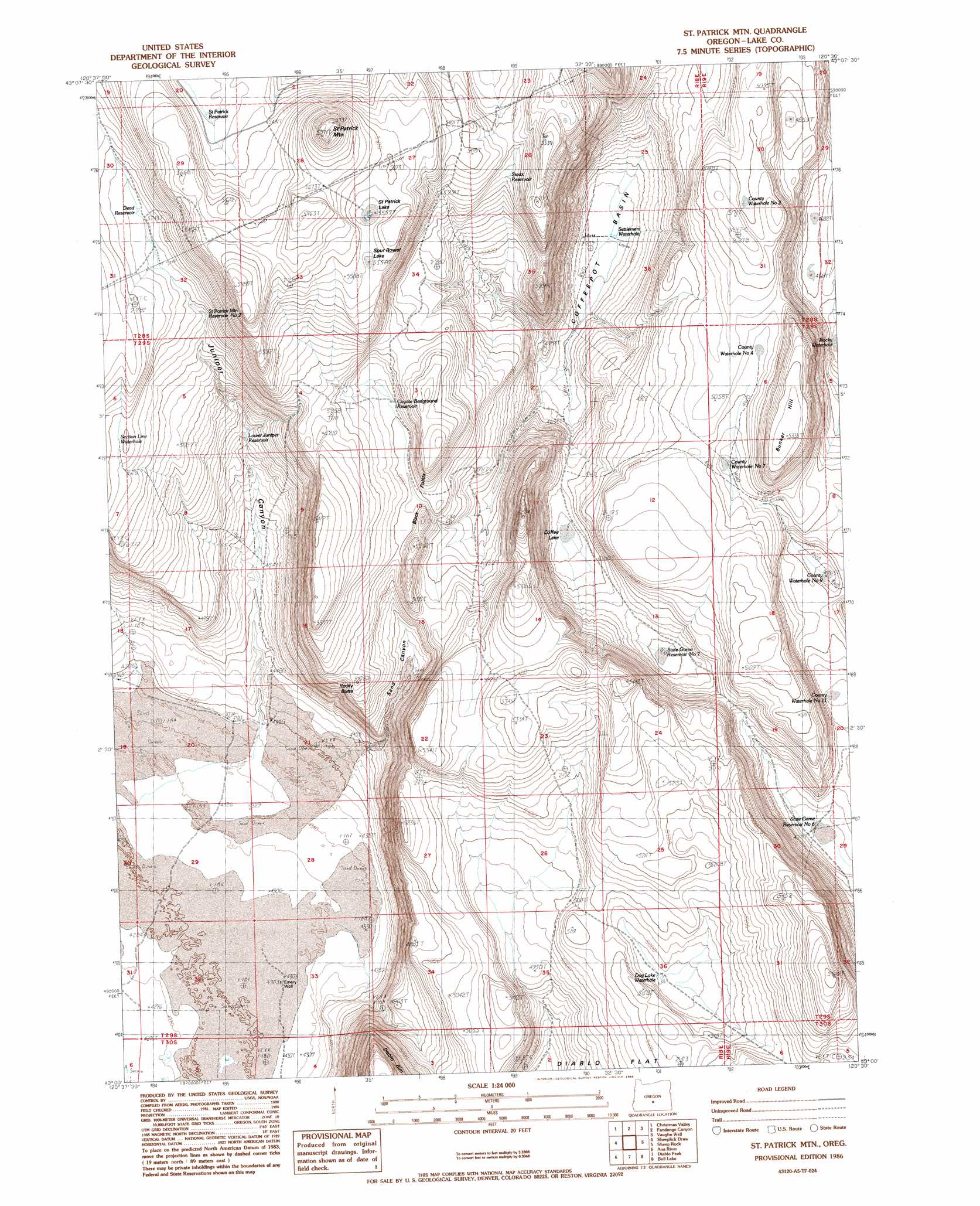
USGS Topo Quad 43120a5 - 1:24,000 scale
| Topo Map Name: | Saint Patrick Mountain |
| USGS Topo Quad ID: | 43120a5 |
| Print Size: | ca. 21 1/4" wide x 27" high |
| Southeast Coordinates: | 43° N latitude / 120.5° W longitude |
| Map Center Coordinates: | 43.0625° N latitude / 120.5625° W longitude |
| U.S. State: | OR |
| Filename: | o43120a5.jpg |
| Download Map JPG Image: | Saint Patrick Mountain topo map 1:24,000 scale |
| Map Type: | Topographic |
| Topo Series: | 7.5´ |
| Map Scale: | 1:24,000 |
| Source of Map Images: | United States Geological Survey (USGS) |
| Alternate Map Versions: |
St. Patrick Mtn. OR 1986, updated 1986 Download PDF Buy paper map Saint Patrick Mountain OR 2011 Download PDF Buy paper map Saint Patrick Mountain OR 2014 Download PDF Buy paper map |
1:24,000 Topo Quads surrounding Saint Patrick Mountain
Lane Lake |
Crack In The Ground |
Christmas Lake |
Fossil Lake |
Sand Rock |
Thorn Lake |
Christmas Valley |
Fandango Canyon |
Vaughn Well |
Buffalo Well |
Egli Rim |
Sheeplick Draw |
Saint Patrick Mountain |
Sheep Rock |
Fire Lake |
Summer Lake |
Ana River |
Diablo Peak |
Bull Lake |
Diatomite Reservoir |
Fremont Point |
South Of Ana River |
Loco Lake |
Sharp Top |
Biscuit Point |
> Back to 43120a1 at 1:100,000 scale
> Back to 43120a1 at 1:250,000 scale
> Back to U.S. Topo Maps home
Saint Patrick Mountain topo map: Gazetteer
Saint Patrick Mountain: Basins
Coffeepot Basin elevation 1386m 4547′Saint Patrick Mountain: Flats
Coffee Lake elevation 1448m 4750′Saint Patrick Lake elevation 1696m 5564′
Spur Rowel Lake elevation 1695m 5561′
Saint Patrick Mountain: Reservoirs
County Waterhole Number 11 elevation 1444m 4737′County Waterhole Number 2 elevation 1552m 5091′
County Waterhole Number 4 elevation 1529m 5016′
County Waterhole Number 7 elevation 1505m 4937′
County Waterhole Number 9 elevation 1450m 4757′
Coyote Bedground Reservoir elevation 1561m 5121′
Dead Reservoir elevation 1602m 5255′
Dog Lake Waterhole elevation 1529m 5016′
Lower Juniper Waterhole elevation 1445m 4740′
Rocky Waterhole elevation 1418m 4652′
Saint Patrick Mountain Reservoir Number Two elevation 1572m 5157′
Saint Patrick Reservoir elevation 1659m 5442′
Section Line Waterhole elevation 1585m 5200′
Settlement Waterhole elevation 1386m 4547′
Sioux Reservoir elevation 1601m 5252′
State Game Reservoir Number 6 elevation 1437m 4714′
State Game Reservoir Number 7 elevation 1463m 4799′
Saint Patrick Mountain: Summits
Black Points elevation 1582m 5190′Bunker Hill elevation 1625m 5331′
Rocky Butte elevation 1553m 5095′
Saint Patrick Mountain elevation 1764m 5787′
Saint Patrick Mountain: Valleys
Juniper Canyon elevation 1336m 4383′Sand Canyon elevation 1397m 4583′
Saint Patrick Mountain: Wells
Emery Well elevation 1315m 4314′Saint Patrick Mountain digital topo map on disk
Buy this Saint Patrick Mountain topo map showing relief, roads, GPS coordinates and other geographical features, as a high-resolution digital map file on DVD: