Hager Mountain Topo Map Oregon
To zoom in, hover over the map of Hager Mountain
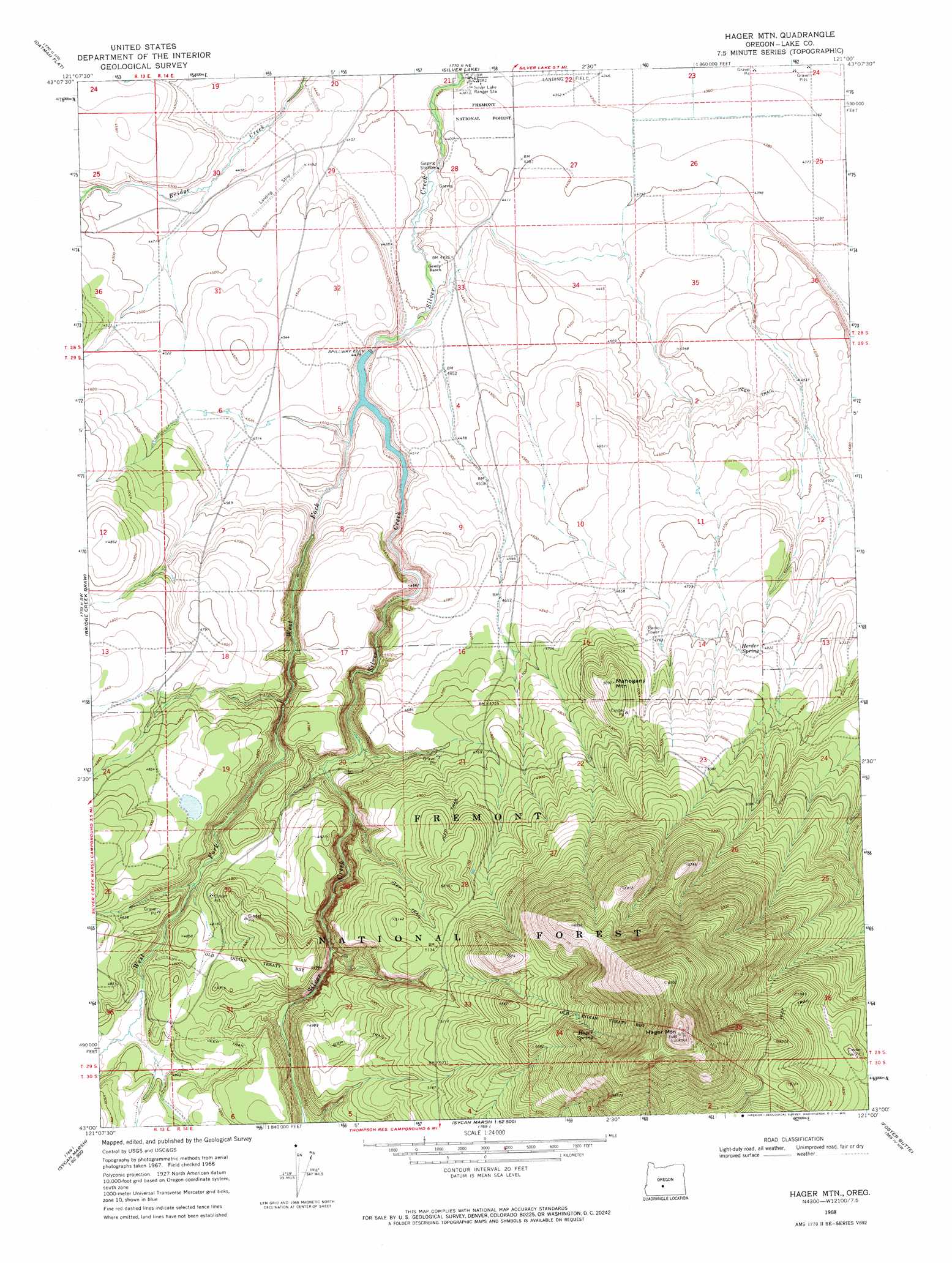
USGS Topo Quad 43121a1 - 1:24,000 scale
| Topo Map Name: | Hager Mountain |
| USGS Topo Quad ID: | 43121a1 |
| Print Size: | ca. 21 1/4" wide x 27" high |
| Southeast Coordinates: | 43° N latitude / 121° W longitude |
| Map Center Coordinates: | 43.0625° N latitude / 121.0625° W longitude |
| U.S. State: | OR |
| Filename: | o43121a1.jpg |
| Download Map JPG Image: | Hager Mountain topo map 1:24,000 scale |
| Map Type: | Topographic |
| Topo Series: | 7.5´ |
| Map Scale: | 1:24,000 |
| Source of Map Images: | United States Geological Survey (USGS) |
| Alternate Map Versions: |
Hager Mtn OR 1968, updated 1971 Download PDF Buy paper map Hager Mtn OR 1968, updated 1972 Download PDF Buy paper map Hager Mountain OR 2004, updated 2007 Download PDF Buy paper map Hager Mountain OR 2011 Download PDF Buy paper map Hager Mountain OR 2014 Download PDF Buy paper map |
| FStopo: | US Forest Service topo Hager Mountain is available: Download FStopo PDF Download FStopo TIF |
1:24,000 Topo Quads surrounding Hager Mountain
Wickiup Spring |
Mccarty Butte |
Fort Rock |
Schaub Lake |
Lane Lake |
Antelope Mountain |
Oatman Flat |
Silver Lake |
Tuff Butte |
Thorn Lake |
Rodman Rock |
Bridge Creek Draw |
Hager Mountain |
Duncan Reservoir |
Egli Rim |
Yamsay Mountain |
Partin Butte |
Thompson Reservoir |
Foster Butte |
Summer Lake |
Hamelton Butte |
Sycan Marsh West |
Sycan Marsh East |
Pole Butte |
Fremont Point |
> Back to 43121a1 at 1:100,000 scale
> Back to 43120a1 at 1:250,000 scale
> Back to U.S. Topo Maps home
Hager Mountain topo map: Gazetteer
Hager Mountain: Airports
Red and White Airport elevation 1330m 4363′Silver Lake Forest Service Strip elevation 1370m 4494′
Hager Mountain: Areas
Chase Spring Administrative Study Plot elevation 1477m 4845′Hager Mountain: Canals
Silver L Canal elevation 1353m 4438′Hager Mountain: Dams
Silver Creek Diversion Dam elevation 1353m 4438′Hager Mountain: Lakes
Rocky Waterhole elevation 1381m 4530′Hager Mountain: Reservoirs
Airstrip Reservoir elevation 1378m 4520′Blow Waterhole elevation 1411m 4629′
Burn Waterhole elevation 1375m 4511′
Hagadorn Waterhole elevation 1428m 4685′
Silver Creek Reservoir elevation 1353m 4438′
Silver L I D Reservoir elevation 1359m 4458′
Hager Mountain: Springs
Hager Spring elevation 1786m 5859′Herder Spring elevation 1474m 4835′
Hager Mountain: Streams
West Fork Silver Creek elevation 1353m 4438′Hager Mountain: Summits
Hager Mountain elevation 2188m 7178′Mahogany Mountain elevation 1550m 5085′
Hager Mountain: Trails
Hager Trail elevation 2070m 6791′Hager Mountain digital topo map on disk
Buy this Hager Mountain topo map showing relief, roads, GPS coordinates and other geographical features, as a high-resolution digital map file on DVD: