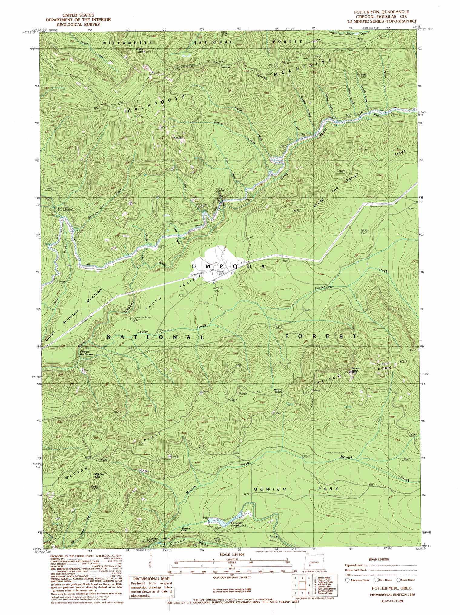
Potter Mountain Topo Map Oregon
To zoom in, hover over the map of Potter Mountain
USGS Topo Quad 43122c3 - 1:24,000 scale
| Topo Map Name: | Potter Mountain |
| USGS Topo Quad ID: | 43122c3 |
| Print Size: | ca. 21 1/4" wide x 27" high |
| Southeast Coordinates: | 43.25° N latitude / 122.25° W longitude |
| Map Center Coordinates: | 43.3125° N latitude / 122.3125° W longitude |
| U.S. State: | OR |
| Filename: | o43122c3.jpg |
| Download Map JPG Image: | Potter Mountain topo map 1:24,000 scale |
| Map Type: | Topographic |
| Topo Series: | 7.5´ |
| Map Scale: | 1:24,000 |
| Source of Map Images: | United States Geological Survey (USGS) |
| Alternate Map Versions: |
Potter Mtn OR 1986, updated 1986 Download PDF Buy paper map Potter Mountain OR 1998, updated 2000 Download PDF Buy paper map Potter Mountain OR 2011 Download PDF Buy paper map Potter Mountain OR 2014 Download PDF Buy paper map |
| FStopo: | US Forest Service topo Potter Mountain is available: Download FStopo PDF Download FStopo TIF |
1:24,000 Topo Quads surrounding Potter Mountain
Bearbones Mountain |
Warner Mountain |
Groundhog Mountain |
Diamond Peak |
Willamette Pass |
Reynolds Ridge |
Staley Ridge |
Rigdon Point |
Emigrant Butte |
Cowhorn Mountain |
Illahee Rock |
Toketee Falls |
Potter Mountain |
Lemolo Lake |
Tolo Mountain |
Twin Lakes Mountain |
Fish Creek Desert |
Garwood Butte |
Diamond Lake |
Mount Thielsen |
Buckeye Lake |
Fish Mountain |
Hamaker Butte |
Pumice Desert West |
Pumice Desert East |
> Back to 43122a1 at 1:100,000 scale
> Back to 43122a1 at 1:250,000 scale
> Back to U.S. Topo Maps home
Potter Mountain topo map: Gazetteer
Potter Mountain: Canals
Lemolo Number 2 Canal elevation 999m 3277′Potter Mountain: Dams
Clearwater Number One Forebay Dam elevation 1173m 3848′Clearwater Number Two Forebay Dam elevation 1015m 3330′
Deer Creek Diversion Dam elevation 986m 3234′
Potter Mountain: Flats
Mowich Park elevation 1271m 4169′Thorn Prairie elevation 953m 3126′
Upper Mountain Meadows elevation 943m 3093′
Potter Mountain: Gaps
Watson Saddle elevation 1424m 4671′Potter Mountain: Reservoirs
Clearwater Number One Forebay elevation 1173m 3848′Clearwater Number Two Forebay elevation 1015m 3330′
Potter Mountain: Ridges
Dread and Terror Ridge elevation 1411m 4629′Watson Ridge elevation 1590m 5216′
Potter Mountain: Springs
Umpqua Hot Springs elevation 861m 2824′Potter Mountain: Streams
Alvin Creek elevation 891m 2923′Barkenberger Creek elevation 915m 3001′
Beverly Creek elevation 999m 3277′
Charlie Creek elevation 948m 3110′
Dorothy Creek elevation 968m 3175′
Helen Creek elevation 986m 3234′
Karen Creek elevation 987m 3238′
Laura Creek elevation 936m 3070′
Loafer Creek elevation 812m 2664′
Mowich Creek elevation 981m 3218′
Nancy Creek elevation 1011m 3316′
Norma Creek elevation 989m 3244′
Nurse Creek elevation 922m 3024′
Patricia Creek elevation 915m 3001′
Potter Creek elevation 962m 3156′
Sally Creek elevation 949m 3113′
Potter Mountain: Summits
Pig Iron Mountain elevation 1644m 5393′Potter Mountain elevation 1812m 5944′
Watson Butte elevation 1726m 5662′
Potter Mountain: Trails
Calapooya Trail elevation 1751m 5744′Pig Iron Trail elevation 1588m 5209′
Potter Mountain Trail elevation 1287m 4222′
Potter Mountain digital topo map on disk
Buy this Potter Mountain topo map showing relief, roads, GPS coordinates and other geographical features, as a high-resolution digital map file on DVD: