Steamboat Topo Map Oregon
To zoom in, hover over the map of Steamboat
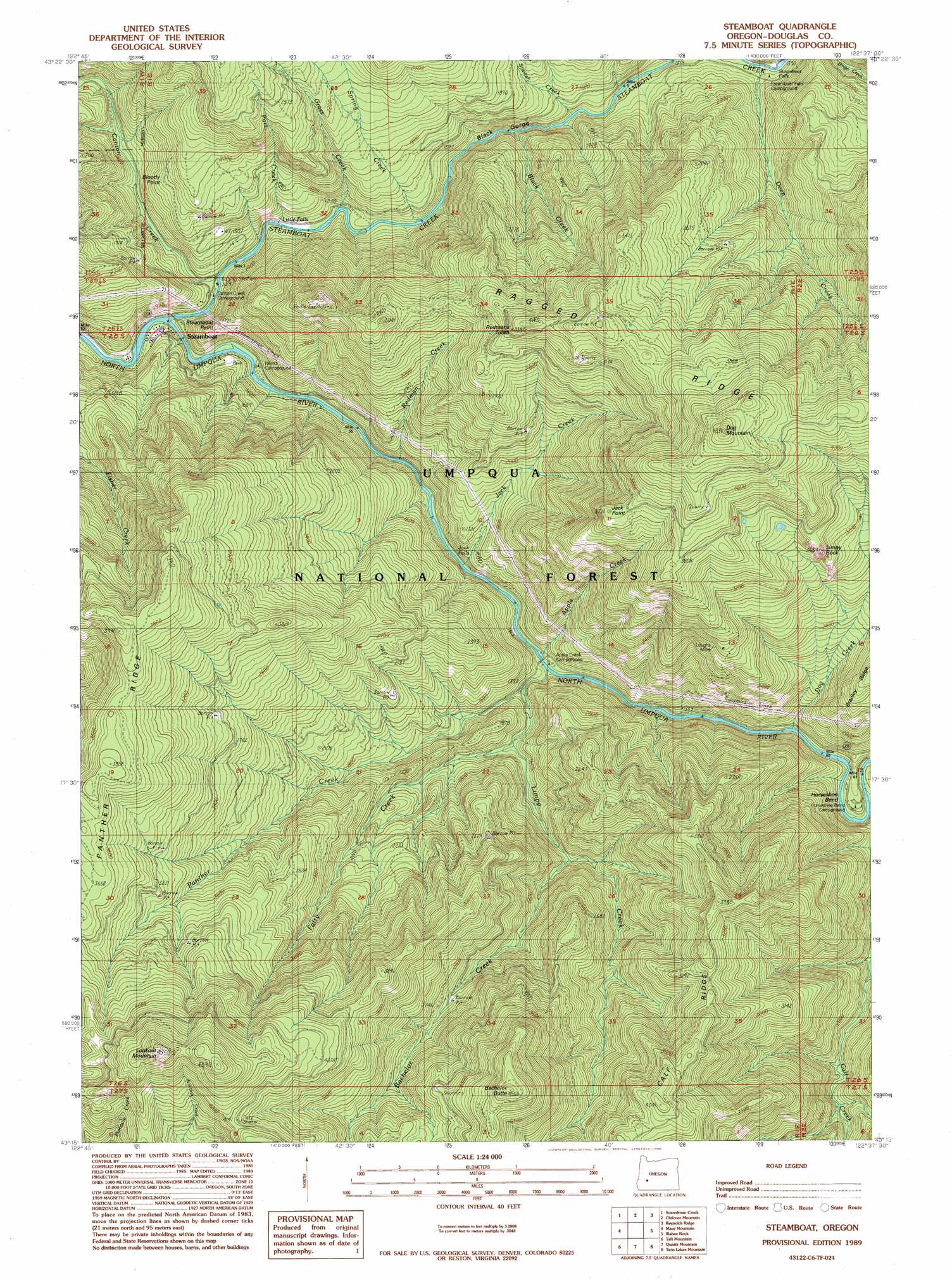
USGS Topo Quad 43122c6 - 1:24,000 scale
| Topo Map Name: | Steamboat |
| USGS Topo Quad ID: | 43122c6 |
| Print Size: | ca. 21 1/4" wide x 27" high |
| Southeast Coordinates: | 43.25° N latitude / 122.625° W longitude |
| Map Center Coordinates: | 43.3125° N latitude / 122.6875° W longitude |
| U.S. State: | OR |
| Filename: | o43122c6.jpg |
| Download Map JPG Image: | Steamboat topo map 1:24,000 scale |
| Map Type: | Topographic |
| Topo Series: | 7.5´ |
| Map Scale: | 1:24,000 |
| Source of Map Images: | United States Geological Survey (USGS) |
| Alternate Map Versions: |
Steamboat OR 1989, updated 1990 Download PDF Buy paper map Steamboat OR 1997, updated 2000 Download PDF Buy paper map Steamboat OR 2011 Download PDF Buy paper map Steamboat OR 2014 Download PDF Buy paper map |
| FStopo: | US Forest Service topo Steamboat is available: Download FStopo PDF Download FStopo TIF |
1:24,000 Topo Quads surrounding Steamboat
Burnt Mountain |
Silica Mountain |
Fairview Peak |
Bearbones Mountain |
Warner Mountain |
Harrington Creek |
Scaredman Creek |
Chilcoot Mountain |
Reynolds Ridge |
Staley Ridge |
Old Fairview |
Mace Mountain |
Steamboat |
Illahee Rock |
Toketee Falls |
Red Butte |
Taft Mountain |
Quartz Mountain |
Twin Lakes Mountain |
Fish Creek Desert |
Deadman Mountain |
Dumont Creek |
Acker Rock |
Buckeye Lake |
Fish Mountain |
> Back to 43122a1 at 1:100,000 scale
> Back to 43122a1 at 1:250,000 scale
> Back to U.S. Topo Maps home
Steamboat topo map: Gazetteer
Steamboat: Bends
Horseshoe Bend elevation 416m 1364′Steamboat: Capes
Bloody Point elevation 497m 1630′Steamboat: Falls
Jack Falls elevation 380m 1246′Little Falls elevation 359m 1177′
Steamboat Falls elevation 427m 1400′
Steamboat: Forests
Umpqua National Forest elevation 1152m 3779′Steamboat: Mines
Loughs Mine elevation 884m 2900′Steamboat: Pillars
Limpy Rock elevation 1012m 3320′Steamboat: Populated Places
Steamboat elevation 335m 1099′Steamboat: Ridges
Calf Ridge elevation 1063m 3487′Panther Ridge elevation 1127m 3697′
Ragged Ridge elevation 1313m 4307′
Steamboat: Springs
Winslow Cabin Spring elevation 972m 3188′Steamboat: Streams
Apple Creek elevation 402m 1318′Bachelor Creek elevation 526m 1725′
Black Creek elevation 415m 1361′
Canton Creek elevation 347m 1138′
Deep Creek elevation 428m 1404′
Dog Creek elevation 430m 1410′
Fairy Creek elevation 474m 1555′
Grass Creek elevation 366m 1200′
Jack Creek elevation 414m 1358′
Limpy Creek elevation 409m 1341′
Panther Creek elevation 391m 1282′
Part Creek elevation 353m 1158′
Redman Creek elevation 373m 1223′
Siwash Creek elevation 418m 1371′
Spring Creek elevation 371m 1217′
Station Creek elevation 382m 1253′
Steamboat Creek elevation 339m 1112′
Steelhead Creek elevation 418m 1371′
Steamboat: Summits
Bachelor Butte elevation 1379m 4524′Dog Mountain elevation 1468m 4816′
Jack Point elevation 1109m 3638′
Lookout Mountain elevation 1522m 4993′
Redmans Tooth elevation 1072m 3517′
Steamboat Point elevation 589m 1932′
Steamboat: Trails
Panther Trail elevation 967m 3172′Steamboat: Valleys
Black Gorge elevation 401m 1315′Steamboat digital topo map on disk
Buy this Steamboat topo map showing relief, roads, GPS coordinates and other geographical features, as a high-resolution digital map file on DVD: