Cowhorn Mountain Topo Map Oregon
To zoom in, hover over the map of Cowhorn Mountain
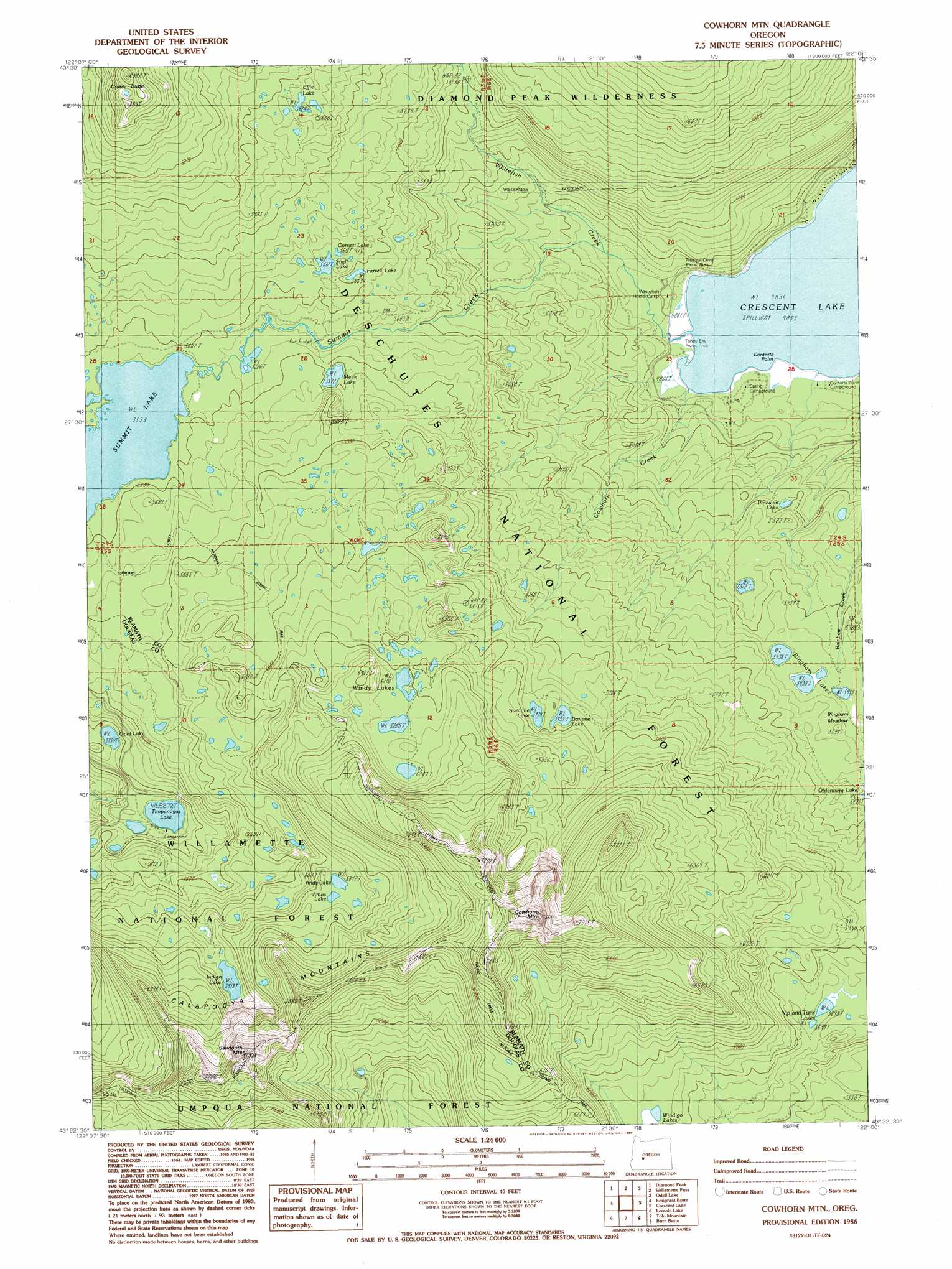
USGS Topo Quad 43122d1 - 1:24,000 scale
| Topo Map Name: | Cowhorn Mountain |
| USGS Topo Quad ID: | 43122d1 |
| Print Size: | ca. 21 1/4" wide x 27" high |
| Southeast Coordinates: | 43.375° N latitude / 122° W longitude |
| Map Center Coordinates: | 43.4375° N latitude / 122.0625° W longitude |
| U.S. State: | OR |
| Filename: | o43122d1.jpg |
| Download Map JPG Image: | Cowhorn Mountain topo map 1:24,000 scale |
| Map Type: | Topographic |
| Topo Series: | 7.5´ |
| Map Scale: | 1:24,000 |
| Source of Map Images: | United States Geological Survey (USGS) |
| Alternate Map Versions: |
Cowhorn Mtn OR 1986, updated 1986 Download PDF Buy paper map Cowhorn Mountain OR 1997, updated 2001 Download PDF Buy paper map Cowhorn Mountain OR 2011 Download PDF Buy paper map Cowhorn Mountain OR 2014 Download PDF Buy paper map |
| FStopo: | US Forest Service topo Cowhorn Mountain is available: Download FStopo PDF Download FStopo TIF |
1:24,000 Topo Quads surrounding Cowhorn Mountain
Mccredie Springs |
Mount David Douglas |
Waldo Lake |
The Twins |
Davis Mountain |
Groundhog Mountain |
Diamond Peak |
Willamette Pass |
Odell Lake |
Hamner Butte |
Rigdon Point |
Emigrant Butte |
Cowhorn Mountain |
Crescent Lake |
Odell Butte |
Potter Mountain |
Lemolo Lake |
Tolo Mountain |
Burn Butte |
Muttonchop Butte |
Garwood Butte |
Diamond Lake |
Mount Thielsen |
Miller Lake |
Chemult |
> Back to 43122a1 at 1:100,000 scale
> Back to 43122a1 at 1:250,000 scale
> Back to U.S. Topo Maps home
Cowhorn Mountain topo map: Gazetteer
Cowhorn Mountain: Bays
Tandy Bay elevation 1475m 4839′Tranquil Cove elevation 1475m 4839′
Cowhorn Mountain: Capes
Contorta Point elevation 1475m 4839′Greenwood Point elevation 1475m 4839′
Cowhorn Mountain: Flats
Bingham Meadow elevation 1680m 5511′Cowhorn Mountain: Lakes
Amos Lake elevation 1839m 6033′Andy Lake elevation 1844m 6049′
Bingham Lakes elevation 1659m 5442′
Cornett Lake elevation 1719m 5639′
Darlene Lake elevation 1810m 5938′
Effie Lake elevation 1807m 5928′
Farrell Lake elevation 1706m 5597′
Indigo Lake elevation 1804m 5918′
Meek Lake elevation 1700m 5577′
Nip and Tuck Lakes elevation 1744m 5721′
Opal Lake elevation 1633m 5357′
Pinewan Lake elevation 1583m 5193′
Snell Lake elevation 1712m 5616′
Summit Lake elevation 1694m 5557′
Suzanne Lake elevation 1810m 5938′
Timpanogas Lake elevation 1608m 5275′
Windy Lakes elevation 1896m 6220′
Cowhorn Mountain: Streams
Cowhorn Creek elevation 1475m 4839′Mountain Creek elevation 1651m 5416′
Summit Creek elevation 1475m 4839′
Whitefish Creek elevation 1497m 4911′
Cowhorn Mountain: Summits
Cowhorn Mountain elevation 2329m 7641′Crater Butte elevation 2069m 6788′
Sawtooth Mountain elevation 2216m 7270′
Cowhorn Mountain: Trails
Windy Lakes Trail elevation 1706m 5597′Windy Pass Way elevation 1998m 6555′
Cowhorn Mountain digital topo map on disk
Buy this Cowhorn Mountain topo map showing relief, roads, GPS coordinates and other geographical features, as a high-resolution digital map file on DVD: