Staley Ridge Topo Map Oregon
To zoom in, hover over the map of Staley Ridge
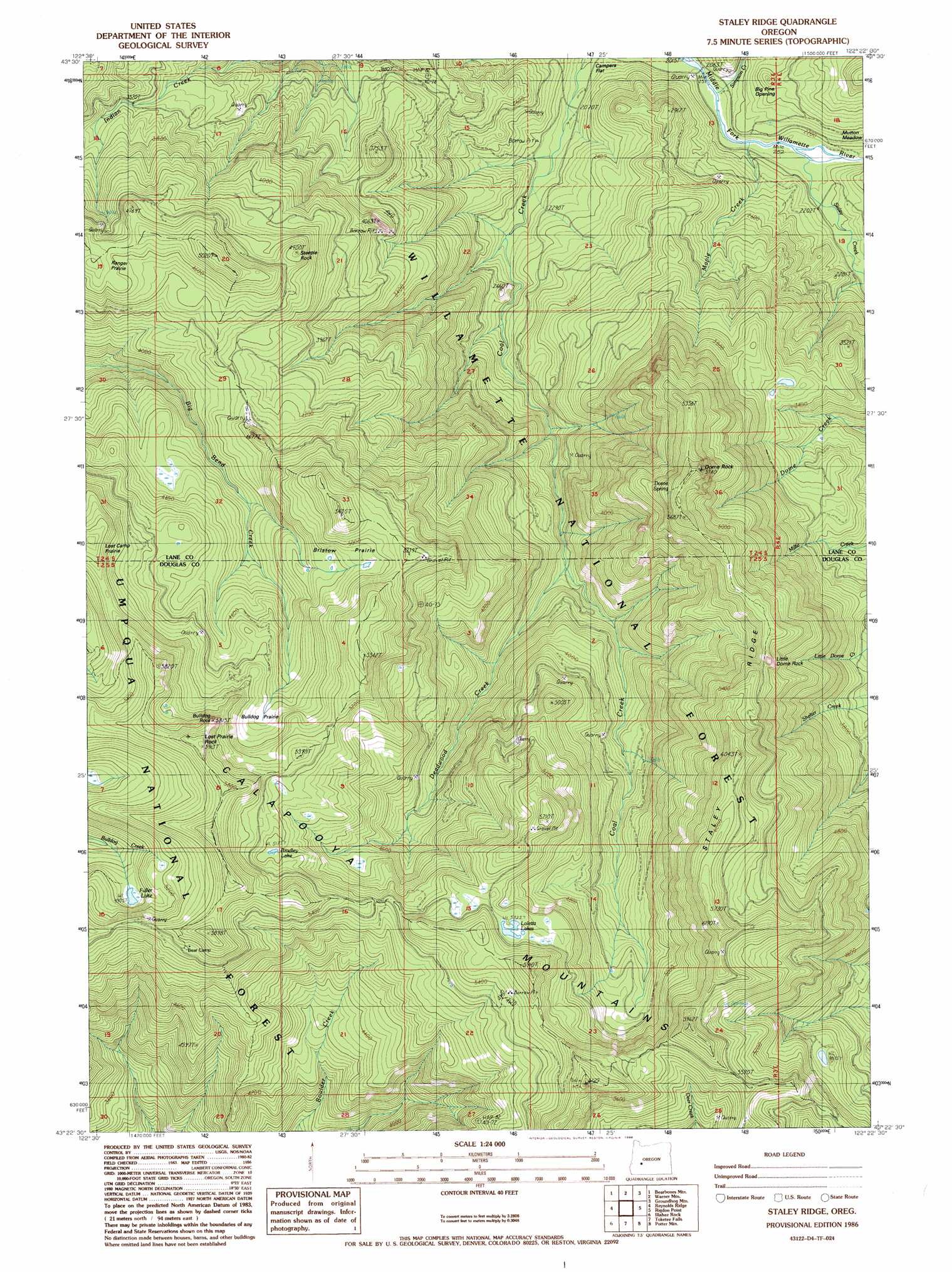
USGS Topo Quad 43122d4 - 1:24,000 scale
| Topo Map Name: | Staley Ridge |
| USGS Topo Quad ID: | 43122d4 |
| Print Size: | ca. 21 1/4" wide x 27" high |
| Southeast Coordinates: | 43.375° N latitude / 122.375° W longitude |
| Map Center Coordinates: | 43.4375° N latitude / 122.4375° W longitude |
| U.S. State: | OR |
| Filename: | o43122d4.jpg |
| Download Map JPG Image: | Staley Ridge topo map 1:24,000 scale |
| Map Type: | Topographic |
| Topo Series: | 7.5´ |
| Map Scale: | 1:24,000 |
| Source of Map Images: | United States Geological Survey (USGS) |
| Alternate Map Versions: |
Staley Ridge OR 1986, updated 1986 Download PDF Buy paper map Staley Ridge OR 1997, updated 1998 Download PDF Buy paper map Staley Ridge OR 2011 Download PDF Buy paper map Staley Ridge OR 2014 Download PDF Buy paper map |
| FStopo: | US Forest Service topo Staley Ridge is available: Download FStopo PDF Download FStopo TIF |
1:24,000 Topo Quads surrounding Staley Ridge
Rose Hill |
Holland Point |
Oakridge |
Mccredie Springs |
Mount David Douglas |
Fairview Peak |
Bearbones Mountain |
Warner Mountain |
Groundhog Mountain |
Diamond Peak |
Chilcoot Mountain |
Reynolds Ridge |
Staley Ridge |
Rigdon Point |
Emigrant Butte |
Steamboat |
Illahee Rock |
Toketee Falls |
Potter Mountain |
Lemolo Lake |
Quartz Mountain |
Twin Lakes Mountain |
Fish Creek Desert |
Garwood Butte |
Diamond Lake |
> Back to 43122a1 at 1:100,000 scale
> Back to 43122a1 at 1:250,000 scale
> Back to U.S. Topo Maps home
Staley Ridge topo map: Gazetteer
Staley Ridge: Flats
Big Pine Opening elevation 720m 2362′Bristow Prairie elevation 1470m 4822′
Bulldog Prairie elevation 1486m 4875′
Campers Flat elevation 640m 2099′
Mutton Meadow elevation 710m 2329′
Picture Rock Prairie elevation 1643m 5390′
Ranger Prairie elevation 1420m 4658′
Staley Ridge: Lakes
Bradley Lake elevation 1583m 5193′Fuller Lake elevation 1496m 4908′
Loletta Lakes elevation 1625m 5331′
Staley Ridge: Pillars
Bulldog Rock elevation 1757m 5764′Dome Rock elevation 1712m 5616′
Little Dome Rock elevation 1570m 5150′
Lost Prairie Rock elevation 1781m 5843′
Steeple Rock elevation 1412m 4632′
Staley Ridge: Ridges
Staley Ridge elevation 1697m 5567′Staley Ridge: Springs
Dome Spring elevation 1627m 5337′Staley Ridge: Streams
Deadwood Creek elevation 980m 3215′Gravel Creek elevation 620m 2034′
Maple Creek elevation 651m 2135′
Simpson Creek elevation 638m 2093′
Staley Creek elevation 647m 2122′
Staley Ridge: Summits
Balm Mountain elevation 1856m 6089′Ranger Stone elevation 1390m 4560′
Staley Ridge: Trails
Bristow Trail elevation 1610m 5282′Indian Creek Trail elevation 940m 3083′
Lost Camp Trail elevation 1658m 5439′
Staley Ridge Trail elevation 1756m 5761′
Staley Ridge digital topo map on disk
Buy this Staley Ridge topo map showing relief, roads, GPS coordinates and other geographical features, as a high-resolution digital map file on DVD: