Mount David Douglas Topo Map Oregon
To zoom in, hover over the map of Mount David Douglas
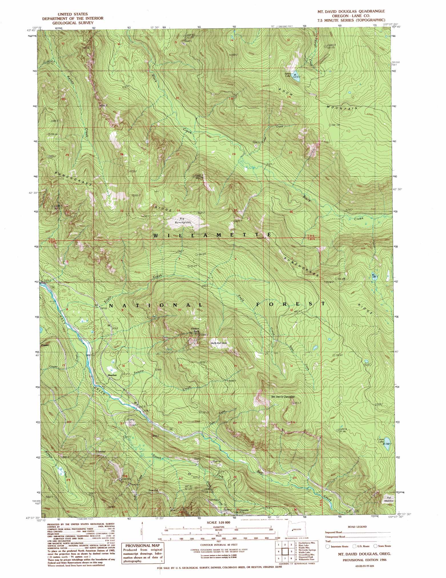
USGS Topo Quad 43122f2 - 1:24,000 scale
| Topo Map Name: | Mount David Douglas |
| USGS Topo Quad ID: | 43122f2 |
| Print Size: | ca. 21 1/4" wide x 27" high |
| Southeast Coordinates: | 43.625° N latitude / 122.125° W longitude |
| Map Center Coordinates: | 43.6875° N latitude / 122.1875° W longitude |
| U.S. State: | OR |
| Filename: | o43122f2.jpg |
| Download Map JPG Image: | Mount David Douglas topo map 1:24,000 scale |
| Map Type: | Topographic |
| Topo Series: | 7.5´ |
| Map Scale: | 1:24,000 |
| Source of Map Images: | United States Geological Survey (USGS) |
| Alternate Map Versions: |
Mt. David Douglas OR 1986, updated 1986 Download PDF Buy paper map Mount David Douglas OR 1997, updated 1998 Download PDF Buy paper map Mount David Douglas OR 2011 Download PDF Buy paper map Mount David Douglas OR 2014 Download PDF Buy paper map |
| FStopo: | US Forest Service topo Mount David Douglas is available: Download FStopo PDF Download FStopo TIF |
1:24,000 Topo Quads surrounding Mount David Douglas
Sinker Mountain |
Sardine Butte |
Grasshopper Mountain |
Chucksney Mountain |
Packsaddle Mountain |
Westfir East |
Huckleberry Mountain |
Blair Lake |
Waldo Mountain |
Irish Mountain |
Oakridge |
Mccredie Springs |
Mount David Douglas |
Waldo Lake |
The Twins |
Warner Mountain |
Groundhog Mountain |
Diamond Peak |
Willamette Pass |
Odell Lake |
Staley Ridge |
Rigdon Point |
Emigrant Butte |
Cowhorn Mountain |
Crescent Lake |
> Back to 43122e1 at 1:100,000 scale
> Back to 43122a1 at 1:250,000 scale
> Back to U.S. Topo Maps home
Mount David Douglas topo map: Gazetteer
Mount David Douglas: Areas
Cornpatch Prairie elevation 1569m 5147′Hells Hall Acre elevation 1502m 4927′
Mount David Douglas: Flats
Fuji Meadow elevation 1714m 5623′Mount David Douglas: Islands
Rhododendron Island elevation 1575m 5167′Mount David Douglas: Lakes
Lucas Lake elevation 1672m 5485′Spirit Lake elevation 1548m 5078′
Mount David Douglas: Parks
Salt Creek Safety Rest Area (historical) elevation 1005m 3297′Mount David Douglas: Pillars
Verdun Rock elevation 1720m 5643′Mount David Douglas: Post Offices
Cruzatte Post Office (historical) elevation 1241m 4071′Mount David Douglas: Ridges
Bunchgrass Ridge elevation 1789m 5869′Mount David Douglas: Streams
Cascade Creek elevation 1116m 3661′Cedar Creek elevation 914m 2998′
Coyote Creek elevation 696m 2283′
Doe Creek elevation 730m 2395′
Eagle Creek elevation 683m 2240′
Last Creek elevation 1330m 4363′
Louise Creek elevation 947m 3106′
Noisy Creek elevation 872m 2860′
Petite Creek elevation 1329m 4360′
Shady Creek elevation 900m 2952′
South Fork Salt Creek elevation 757m 2483′
Swamp Creek elevation 768m 2519′
Twin Creek elevation 851m 2791′
Mount David Douglas: Summits
Big Bunchgrass elevation 1581m 5187′Mount David Douglas elevation 1899m 6230′
Mount David Douglas: Trails
Cupit Mary Trail elevation 1611m 5285′Helen Creek Way elevation 1214m 3982′
Koch Mountain Trail elevation 1744m 5721′
Verdun Way elevation 1407m 4616′
Mount David Douglas digital topo map on disk
Buy this Mount David Douglas topo map showing relief, roads, GPS coordinates and other geographical features, as a high-resolution digital map file on DVD: