Westfir West Topo Map Oregon
To zoom in, hover over the map of Westfir West
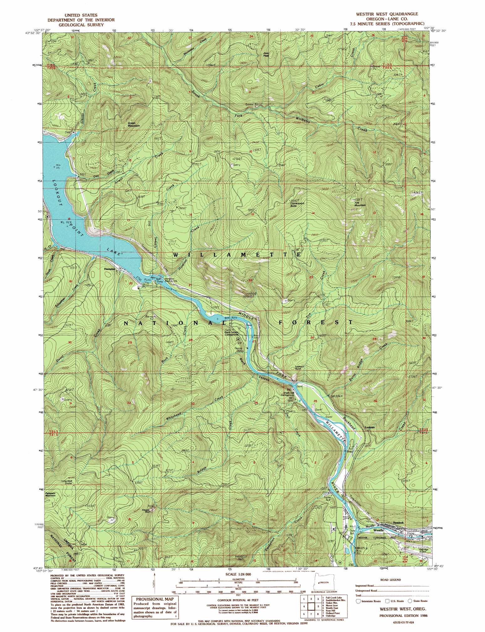
USGS Topo Quad 43122g5 - 1:24,000 scale
| Topo Map Name: | Westfir West |
| USGS Topo Quad ID: | 43122g5 |
| Print Size: | ca. 21 1/4" wide x 27" high |
| Southeast Coordinates: | 43.75° N latitude / 122.5° W longitude |
| Map Center Coordinates: | 43.8125° N latitude / 122.5625° W longitude |
| U.S. State: | OR |
| Filename: | o43122g5.jpg |
| Download Map JPG Image: | Westfir West topo map 1:24,000 scale |
| Map Type: | Topographic |
| Topo Series: | 7.5´ |
| Map Scale: | 1:24,000 |
| Source of Map Images: | United States Geological Survey (USGS) |
| Alternate Map Versions: |
Westfir West OR 1986, updated 1986 Download PDF Buy paper map Westfir West OR 1997, updated 1998 Download PDF Buy paper map Westfir West OR 2011 Download PDF Buy paper map Westfir West OR 2014 Download PDF Buy paper map |
| FStopo: | US Forest Service topo Westfir West is available: Download FStopo PDF Download FStopo TIF |
1:24,000 Topo Quads surrounding Westfir West
Walterville |
Leaburg |
Goat Mountain |
Nimrod |
Harvey Mountain |
Lowell |
Fall Creek Lake |
Saddleblanket Mountain |
Sinker Mountain |
Sardine Butte |
Kloster Mountain |
Mount June |
Westfir West |
Westfir East |
Huckleberry Mountain |
Culp Creek |
Rose Hill |
Holland Point |
Oakridge |
Mccredie Springs |
Silica Mountain |
Fairview Peak |
Bearbones Mountain |
Warner Mountain |
Groundhog Mountain |
> Back to 43122e1 at 1:100,000 scale
> Back to 43122a1 at 1:250,000 scale
> Back to U.S. Topo Maps home
Westfir West topo map: Gazetteer
Westfir West: Airports
Oakridge State Airport elevation 425m 1394′Westfir West: Bridges
Old Barnard Bridge elevation 318m 1043′Westfir West: Cliffs
Lookout Point elevation 489m 1604′Westfir West: Parks
Hampton Park (historical) elevation 292m 958′Westfir West: Pillars
Kreuger Rock elevation 1029m 3375′Westfir West: Post Offices
Landax Post Office (historical) elevation 338m 1108′Westfir West: Streams
Armet Creek elevation 289m 948′Bridge Creek elevation 289m 948′
Buckhead Creek elevation 302m 990′
Burnt Bridge Creek elevation 302m 990′
Cabin Creek elevation 290m 951′
Cabin Creek elevation 537m 1761′
Cain Creek elevation 285m 935′
Carpet Hill Creek elevation 284m 931′
Cloverpatch Creek elevation 297m 974′
Deception Creek elevation 306m 1003′
Dell Creek elevation 291m 954′
Duval Creek elevation 288m 944′
Harper Creek elevation 285m 935′
Hospital Creek elevation 292m 958′
Monterica Creek elevation 448m 1469′
North Creek elevation 293m 961′
North Fork Middle Fork Willamette River elevation 315m 1033′
Rock Creek elevation 284m 931′
School Creek elevation 285m 935′
Schweitzer Creek elevation 291m 954′
South Creek elevation 284m 931′
Sweeney Creek elevation 284m 931′
Tire Creek elevation 317m 1040′
Whitehead Creek elevation 290m 951′
Westfir West: Summits
Cloverpatch Butte elevation 1111m 3645′Green Mountain elevation 771m 2529′
Joes Peak elevation 1040m 3412′
Rock Knob elevation 1003m 3290′
Tire Mountain elevation 1320m 4330′
Westfir West: Trails
Cabin Creek Trail elevation 935m 3067′Cloverpatch Trail elevation 995m 3264′
Sourgrass Trail elevation 753m 2470′
Tire Mountain Trail elevation 727m 2385′
Westfir West: Valleys
Black Canyon elevation 289m 948′Blackcanyon Way elevation 302m 990′
Westfir West digital topo map on disk
Buy this Westfir West topo map showing relief, roads, GPS coordinates and other geographical features, as a high-resolution digital map file on DVD: