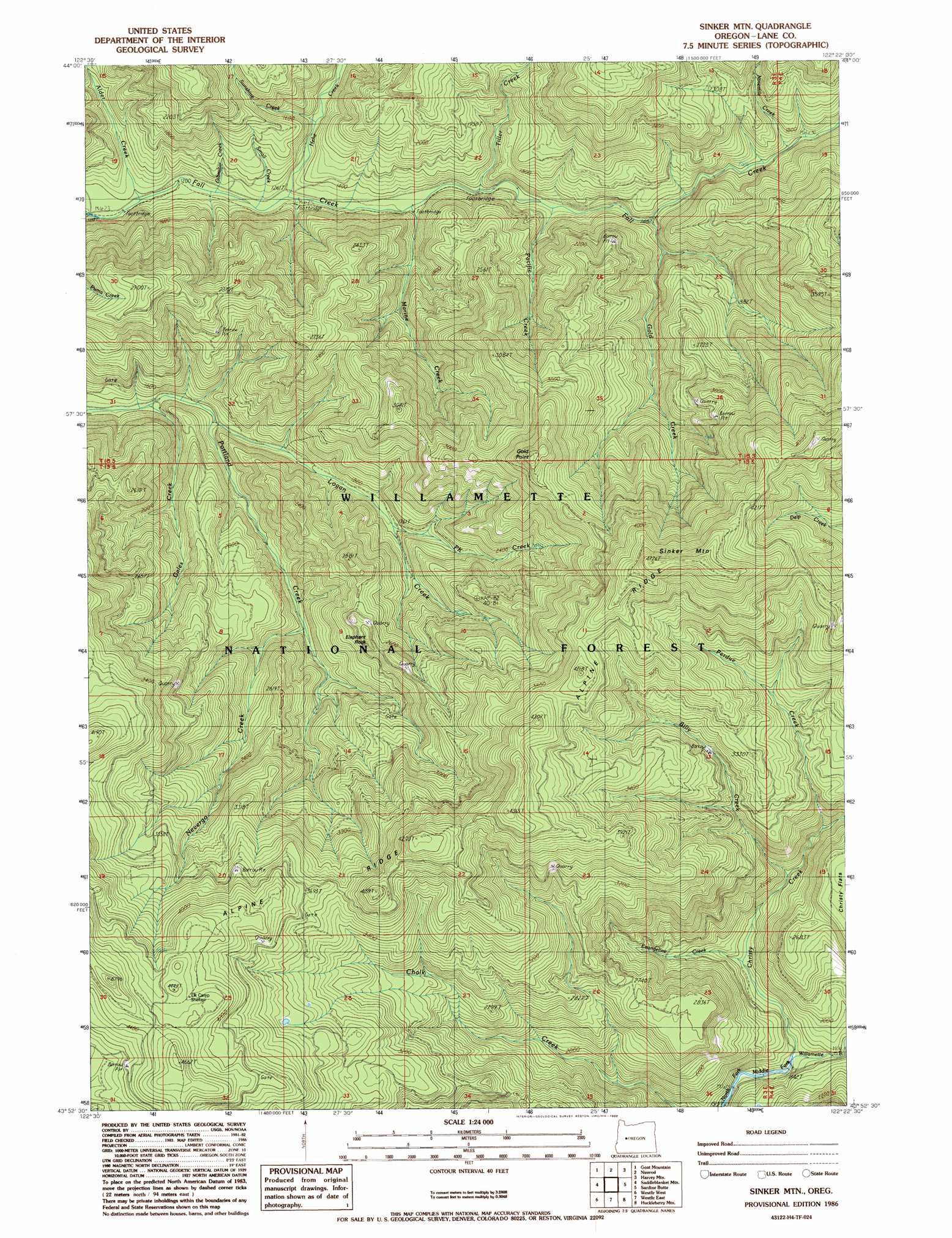
Sinker Mountain Topo Map Oregon
To zoom in, hover over the map of Sinker Mountain
USGS Topo Quad 43122h4 - 1:24,000 scale
| Topo Map Name: | Sinker Mountain |
| USGS Topo Quad ID: | 43122h4 |
| Print Size: | ca. 21 1/4" wide x 27" high |
| Southeast Coordinates: | 43.875° N latitude / 122.375° W longitude |
| Map Center Coordinates: | 43.9375° N latitude / 122.4375° W longitude |
| U.S. State: | OR |
| Filename: | o43122h4.jpg |
| Download Map JPG Image: | Sinker Mountain topo map 1:24,000 scale |
| Map Type: | Topographic |
| Topo Series: | 7.5´ |
| Map Scale: | 1:24,000 |
| Source of Map Images: | United States Geological Survey (USGS) |
| Alternate Map Versions: |
Sinker Mtn OR 1986, updated 1986 Download PDF Buy paper map Sinker Mountain OR 1997, updated 1998 Download PDF Buy paper map Sinker Mountain OR 2011 Download PDF Buy paper map Sinker Mountain OR 2014 Download PDF Buy paper map |
| FStopo: | US Forest Service topo Sinker Mountain is available: Download FStopo PDF Download FStopo TIF |
1:24,000 Topo Quads surrounding Sinker Mountain
Mount Nebo |
Vida |
Mount Hagan |
Blue River |
Mckenzie Bridge |
Leaburg |
Goat Mountain |
Nimrod |
Harvey Mountain |
Cougar Reservoir |
Fall Creek Lake |
Saddleblanket Mountain |
Sinker Mountain |
Sardine Butte |
Grasshopper Mountain |
Mount June |
Westfir West |
Westfir East |
Huckleberry Mountain |
Blair Lake |
Rose Hill |
Holland Point |
Oakridge |
Mccredie Springs |
Mount David Douglas |
> Back to 43122e1 at 1:100,000 scale
> Back to 43122a1 at 1:250,000 scale
> Back to U.S. Topo Maps home
Sinker Mountain topo map: Gazetteer
Sinker Mountain: Mines
Ironside Mine elevation 960m 3149′Sinker Mountain: Ridges
Alpine Ridge elevation 1295m 4248′Marine Ridge elevation 819m 2687′
Sinker Mountain: Streams
Alder Creek elevation 361m 1184′Billy Creek elevation 672m 2204′
Christy Creek elevation 519m 1702′
Delp Creek elevation 493m 1617′
Evangeline Creek elevation 552m 1811′
Gales Creek elevation 415m 1361′
Gibraltar Creek elevation 373m 1223′
Gold Creek elevation 467m 1532′
Hehe Creek elevation 387m 1269′
Logan Creek elevation 428m 1404′
Marine Creek elevation 406m 1332′
Nevergo Creek elevation 535m 1755′
Ninemile Creek elevation 549m 1801′
Pacific Creek elevation 465m 1525′
Perdue Creek elevation 694m 2276′
PK Creek elevation 544m 1784′
Small Creek elevation 381m 1250′
Sunshine Creek elevation 435m 1427′
Tiller Creek elevation 415m 1361′
Tumble Creek elevation 539m 1768′
Sinker Mountain: Summits
Elephant Rock elevation 794m 2604′Gold Point elevation 1141m 3743′
Sinker Mountain elevation 1374m 4507′
Sinker Mountain: Trails
Gold Point Trail elevation 838m 2749′McKinley Creek Trail elevation 1043m 3421′
Sinker Mountain digital topo map on disk
Buy this Sinker Mountain topo map showing relief, roads, GPS coordinates and other geographical features, as a high-resolution digital map file on DVD: