Dodson Butte Topo Map Oregon
To zoom in, hover over the map of Dodson Butte
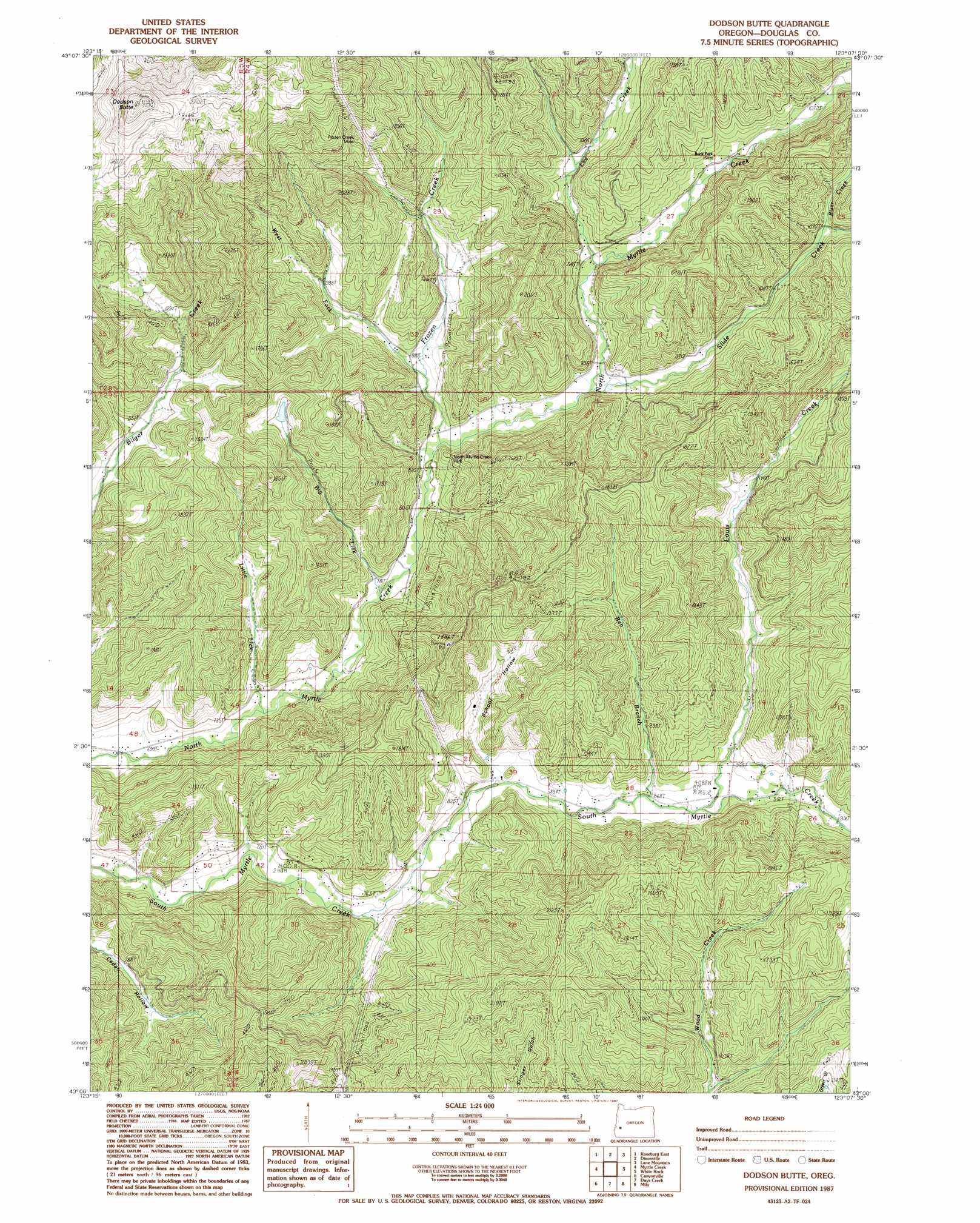
USGS Topo Quad 43123a2 - 1:24,000 scale
| Topo Map Name: | Dodson Butte |
| USGS Topo Quad ID: | 43123a2 |
| Print Size: | ca. 21 1/4" wide x 27" high |
| Southeast Coordinates: | 43° N latitude / 123.125° W longitude |
| Map Center Coordinates: | 43.0625° N latitude / 123.1875° W longitude |
| U.S. State: | OR |
| Filename: | o43123a2.jpg |
| Download Map JPG Image: | Dodson Butte topo map 1:24,000 scale |
| Map Type: | Topographic |
| Topo Series: | 7.5´ |
| Map Scale: | 1:24,000 |
| Source of Map Images: | United States Geological Survey (USGS) |
| Alternate Map Versions: |
Dodson Butte OR 1987, updated 1987 Download PDF Buy paper map Dodson Butte OR 2011 Download PDF Buy paper map Dodson Butte OR 2014 Download PDF Buy paper map |
1:24,000 Topo Quads surrounding Dodson Butte
Garden Valley |
Winchester |
Oak Creek Valley |
Glide |
Old Fairview |
Roseburg West |
Roseburg East |
Dixonville |
Lane Mountain |
Red Butte |
Winston |
Myrtle Creek |
Dodson Butte |
White Rock |
Deadman Mountain |
Nickel Mountain |
Canyonville |
Days Creek |
Milo |
Tiller |
Mccullough Creek |
Quines Creek |
Starvout Creek |
Cedar Springs Mountain |
Richter Mountain |
> Back to 43123a1 at 1:100,000 scale
> Back to 43122a1 at 1:250,000 scale
> Back to U.S. Topo Maps home
Dodson Butte topo map: Gazetteer
Dodson Butte: Falls
Cavitt Falls elevation 238m 780′Dodson Butte: Mines
Frozen Creek Mine elevation 504m 1653′Dodson Butte: Parks
Lehnherr Park elevation 324m 1062′North Myrtle Park elevation 282m 925′
Dodson Butte: Populated Places
Buck Fork (historical) elevation 301m 987′Dodson Butte: Post Offices
Buckfork Post Office (historical) elevation 301m 987′Dodson Butte: Reservoirs
Eleanor Reservoir elevation 400m 1312′Dodson Butte: Streams
Ben Branch elevation 260m 853′Big Lick elevation 231m 757′
Carson Creek elevation 246m 807′
Frozen Creek elevation 472m 1548′
Hamline Creek elevation 304m 997′
Heath Creek elevation 310m 1017′
Lee Creek elevation 276m 905′
Left Fork Frozen Creek elevation 260m 853′
Little Lick elevation 216m 708′
Louis Creek elevation 270m 885′
Riser Creek elevation 323m 1059′
Roseburg Creek elevation 298m 977′
Slide Creek elevation 257m 843′
Stone Creek elevation 347m 1138′
Weaver Creek elevation 310m 1017′
Dodson Butte: Summits
Dodson Butte elevation 973m 3192′Dodson Butte: Valleys
Cox Gulch elevation 317m 1040′Fisher Gulch elevation 304m 997′
Sanderson Gulch elevation 242m 793′
School Hollow elevation 255m 836′
Stewart Gulch elevation 304m 997′
Dodson Butte digital topo map on disk
Buy this Dodson Butte topo map showing relief, roads, GPS coordinates and other geographical features, as a high-resolution digital map file on DVD: