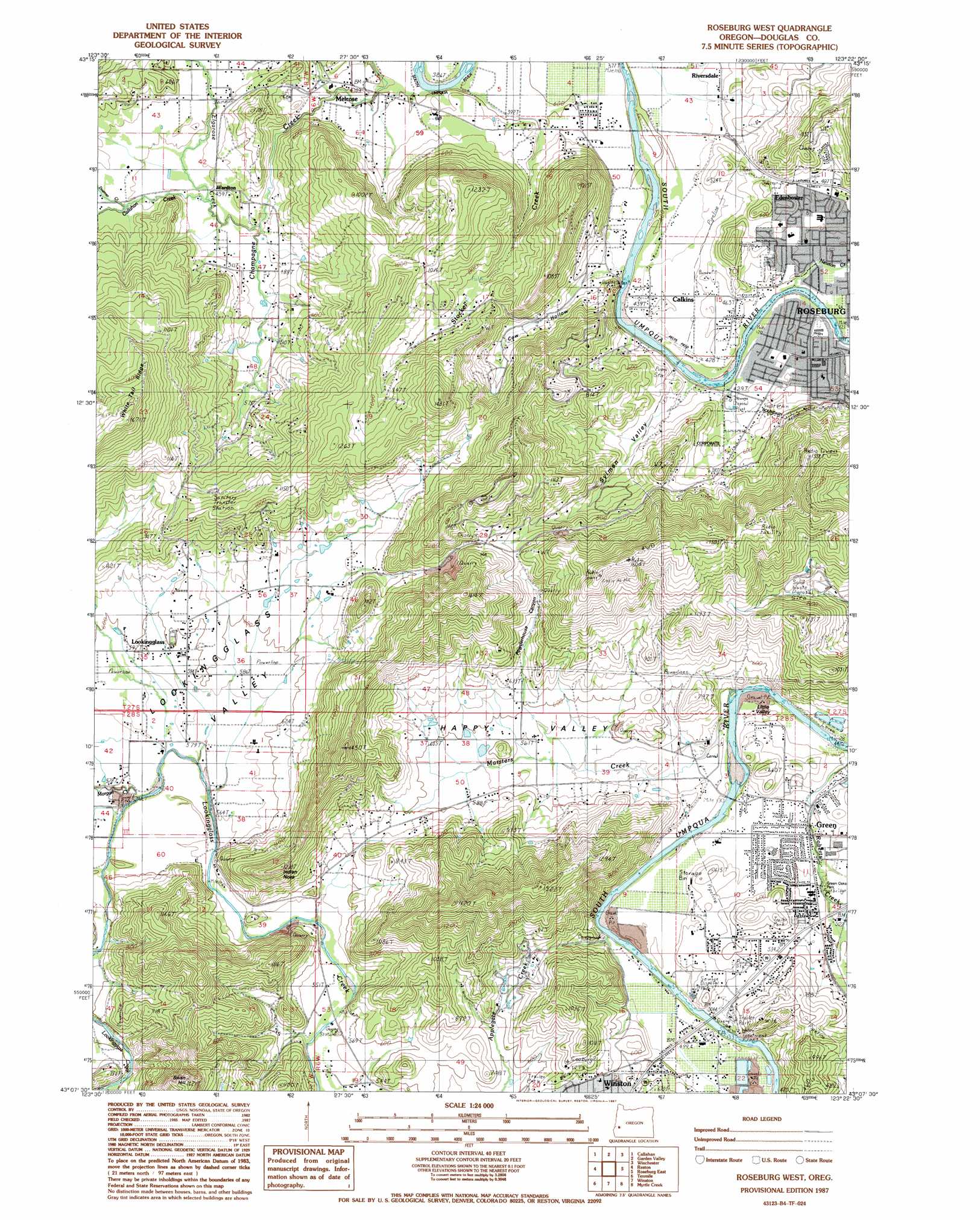
Roseburg West Topo Map Oregon
To zoom in, hover over the map of Roseburg West
USGS Topo Quad 43123b4 - 1:24,000 scale
| Topo Map Name: | Roseburg West |
| USGS Topo Quad ID: | 43123b4 |
| Print Size: | ca. 21 1/4" wide x 27" high |
| Southeast Coordinates: | 43.125° N latitude / 123.375° W longitude |
| Map Center Coordinates: | 43.1875° N latitude / 123.4375° W longitude |
| U.S. State: | OR |
| Filename: | o43123b4.jpg |
| Download Map JPG Image: | Roseburg West topo map 1:24,000 scale |
| Map Type: | Topographic |
| Topo Series: | 7.5´ |
| Map Scale: | 1:24,000 |
| Source of Map Images: | United States Geological Survey (USGS) |
| Alternate Map Versions: |
Roseburg West OR 1987, updated 1987 Download PDF Buy paper map Roseburg West OR 2011 Download PDF Buy paper map Roseburg West OR 2014 Download PDF Buy paper map |
1:24,000 Topo Quads surrounding Roseburg West
Kelly Butte |
Tyee |
Tyee Mountain |
Sutherlin |
Nonpareil |
Cedar Creek |
Callahan |
Garden Valley |
Winchester |
Oak Creek Valley |
Mount Gurney |
Reston |
Roseburg West |
Roseburg East |
Dixonville |
Camas Valley |
Tenmile |
Winston |
Myrtle Creek |
Dodson Butte |
Chipmunk Ridge |
Live Oak Mountain |
Nickel Mountain |
Canyonville |
Days Creek |
> Back to 43123a1 at 1:100,000 scale
> Back to 43122a1 at 1:250,000 scale
> Back to U.S. Topo Maps home
Roseburg West topo map: Gazetteer
Roseburg West: Airports
Felts Field elevation 130m 426′George Felt Airfield elevation 157m 515′
Roseburg West: Bridges
Melrose Bridge elevation 115m 377′Winston Bridge elevation 145m 475′
Roseburg West: Parks
Brown Park elevation 137m 449′Green Oaks County Park elevation 160m 524′
Quintus Park elevation 132m 433′
Roseburg West: Populated Places
Calkins elevation 135m 442′Edenbower elevation 151m 495′
Lookingglass elevation 182m 597′
Melrose elevation 128m 419′
Roseburg West: Post Offices
Edenbower Post Office (historical) elevation 151m 495′Lookingglass Post Office (historical) elevation 182m 597′
Melrose Post Office (historical) elevation 128m 419′
Wanaville Post Office (historical) elevation 140m 459′
Wardton Post Office (historical) elevation 139m 456′
Roseburg West: Reservoirs
Eugene Log Pond elevation 155m 508′Harris Reservoir elevation 174m 570′
Hubbard Pond elevation 187m 613′
Lammys Reservoir elevation 229m 751′
Marsh Reservoir elevation 184m 603′
Rieke Reservoir elevation 257m 843′
Yoder Reservoir elevation 172m 564′
Roseburg West: Streams
Callahan Creek elevation 136m 446′Doerner Creek elevation 148m 485′
Elgarose Creek elevation 134m 439′
Marsters Creek elevation 140m 459′
Morgan Creek elevation 171m 561′
Newton Creek elevation 123m 403′
North Fork Roberts Creek elevation 147m 482′
Stockel Creek elevation 113m 370′
Sweetbriar Creek elevation 134m 439′
Roseburg West: Summits
Indian Nose elevation 366m 1200′Lookingglass Hill elevation 469m 1538′
Swan Hill elevation 480m 1574′
Roseburg West: Valleys
Cow Hollow elevation 130m 426′Happy Valley elevation 147m 482′
Little Valley elevation 147m 482′
Lookingglass Valley elevation 170m 557′
Powderhouse Canyon elevation 193m 633′
Sylman Valley elevation 131m 429′
Roseburg West digital topo map on disk
Buy this Roseburg West topo map showing relief, roads, GPS coordinates and other geographical features, as a high-resolution digital map file on DVD: