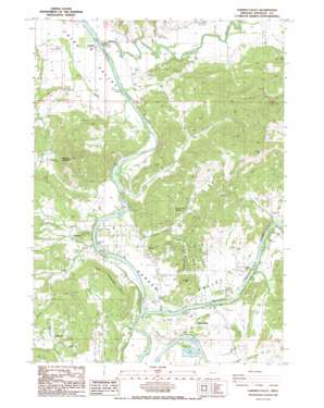
Garden Valley Topo Map Oregon
To zoom in, hover over the map of Garden Valley
USGS Topo Quad 43123c4 - 1:24,000 scale
| Topo Map Name: | Garden Valley |
| USGS Topo Quad ID: | 43123c4 |
| Print Size: | ca. 21 1/4" wide x 27" high |
| Southeast Coordinates: | 43.25° N latitude / 123.375° W longitude |
| Map Center Coordinates: | 43.3125° N latitude / 123.4375° W longitude |
| U.S. State: | OR |
| Filename: | o43123c4.jpg |
| Download Map JPG Image: | Garden Valley topo map 1:24,000 scale |
| Map Type: | Topographic |
| Topo Series: | 7.5´ |
| Map Scale: | 1:24,000 |
| Source of Map Images: | United States Geological Survey (USGS) |
| Alternate Map Versions: |
Garden Valley OR 1987, updated 1987 Download PDF Buy paper map Garden Valley OR 2011 Download PDF Buy paper map Garden Valley OR 2014 Download PDF Buy paper map |
1:24,000 Topo Quads surrounding Garden Valley
> Back to 43123a1 at 1:100,000 scale
> Back to 43122a1 at 1:250,000 scale
> Back to U.S. Topo Maps home
Garden Valley topo map: Gazetteer
Garden Valley: Airports
Harmon Airport elevation 135m 442′Garden Valley: Bridges
Browns Bridge elevation 115m 377′Garden Valley: Parks
Hestness Park elevation 122m 400′River Forks County Park elevation 112m 367′
Singleton Park elevation 117m 383′
Garden Valley: Populated Places
Cleveland elevation 136m 446′Elgarose elevation 184m 603′
Riversdale elevation 124m 406′
Umpqua elevation 98m 321′
Garden Valley: Post Offices
Cleveland Post Office (historical) elevation 136m 446′Elgarose Post Office (historical) elevation 184m 603′
French Settlement Post Office (historical) elevation 111m 364′
Laraut Post Office (historical) elevation 108m 354′
Umpqua Post Office elevation 98m 321′
Winniford Post Office (historical) elevation 130m 426′
Garden Valley: Rapids
Burkhart Rapids elevation 114m 374′Cleveland Rapids elevation 106m 347′
Crow Rapids elevation 101m 331′
Leatherwood Rapids elevation 106m 347′
Garden Valley: Reservoirs
Doerner Reservoir elevation 147m 482′Hidden Valley Reservoir elevation 180m 590′
Garden Valley: Streams
Burke Creek elevation 105m 344′Calapooya Creek elevation 98m 321′
Champagne Creek elevation 113m 370′
Coles Valley Creek elevation 131m 429′
Hidden Valley Creek elevation 104m 341′
North Umpqua River elevation 110m 360′
South Umpqua River elevation 110m 360′
Sutherlin Creek elevation 125m 410′
Sutherlin Creek elevation 129m 423′
Willow Creek elevation 159m 521′
Garden Valley: Summits
Cleveland Hill elevation 273m 895′Coyote Hill elevation 255m 836′
Red Hill elevation 245m 803′
Woodruff Mountain elevation 493m 1617′
Garden Valley: Valleys
Champagne Creek Valley elevation 117m 383′Garden Valley elevation 103m 337′
Garden Valley digital topo map on disk
Buy this Garden Valley topo map showing relief, roads, GPS coordinates and other geographical features, as a high-resolution digital map file on DVD:


