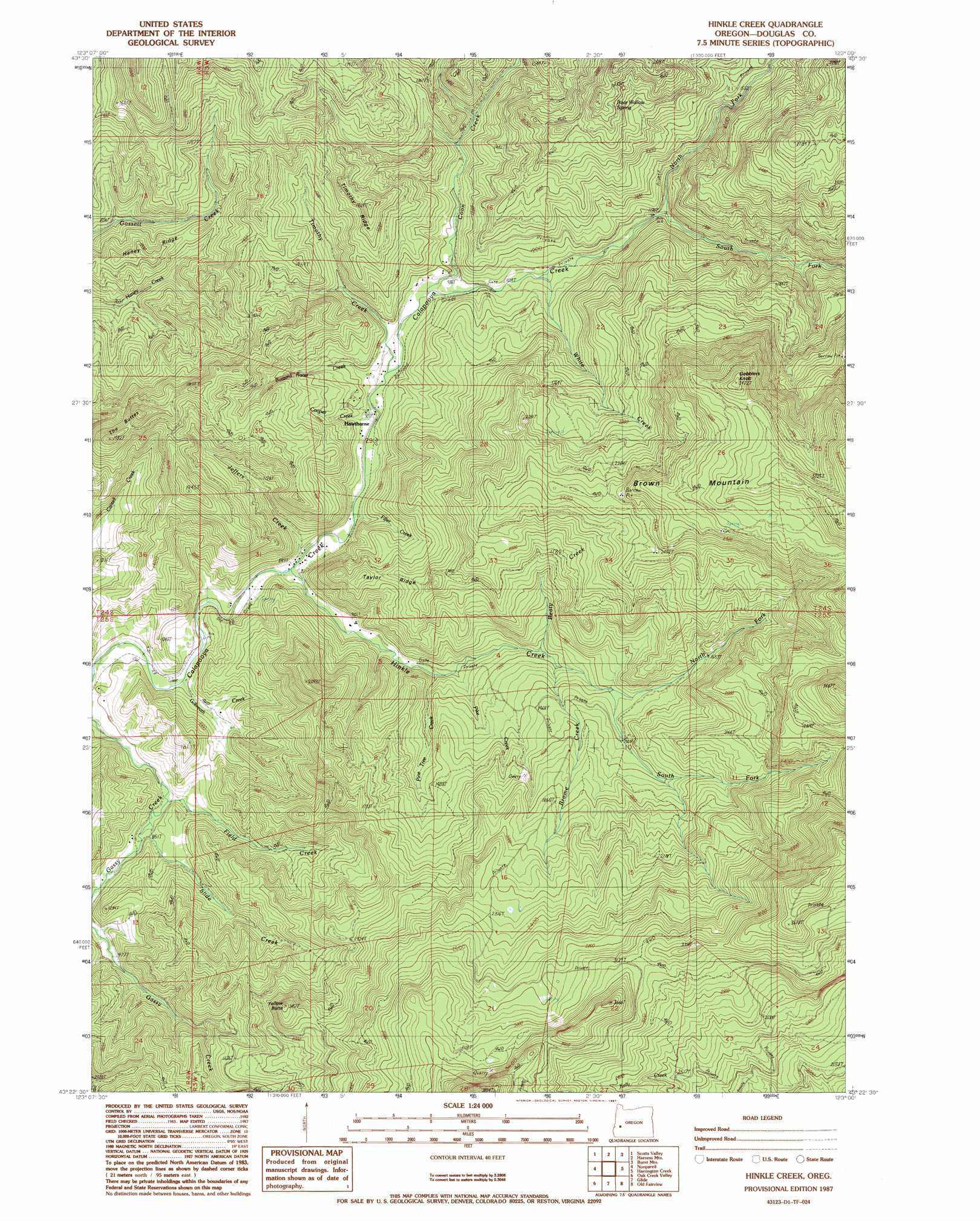
Hinkle Creek Topo Map Oregon
To zoom in, hover over the map of Hinkle Creek
USGS Topo Quad 43123d1 - 1:24,000 scale
| Topo Map Name: | Hinkle Creek |
| USGS Topo Quad ID: | 43123d1 |
| Print Size: | ca. 21 1/4" wide x 27" high |
| Southeast Coordinates: | 43.375° N latitude / 123° W longitude |
| Map Center Coordinates: | 43.4375° N latitude / 123.0625° W longitude |
| U.S. State: | OR |
| Filename: | o43123d1.jpg |
| Download Map JPG Image: | Hinkle Creek topo map 1:24,000 scale |
| Map Type: | Topographic |
| Topo Series: | 7.5´ |
| Map Scale: | 1:24,000 |
| Source of Map Images: | United States Geological Survey (USGS) |
| Alternate Map Versions: |
Hinkle Creek OR 1987, updated 1987 Download PDF Buy paper map Hinkle Creek OR 2011 Download PDF Buy paper map Hinkle Creek OR 2014 Download PDF Buy paper map |
1:24,000 Topo Quads surrounding Hinkle Creek
Drain |
Curtin |
Cottage Grove Lake |
Blue Mountain |
Culp Creek |
Yoncalla |
Scotts Valley |
Harness Mountain |
Burnt Mountain |
Silica Mountain |
Sutherlin |
Nonpareil |
Hinkle Creek |
Harrington Creek |
Scaredman Creek |
Winchester |
Oak Creek Valley |
Glide |
Old Fairview |
Mace Mountain |
Roseburg East |
Dixonville |
Lane Mountain |
Red Butte |
Taft Mountain |
> Back to 43123a1 at 1:100,000 scale
> Back to 43122a1 at 1:250,000 scale
> Back to U.S. Topo Maps home
Hinkle Creek topo map: Gazetteer
Hinkle Creek: Populated Places
Hawthorne elevation 278m 912′Hinkle Creek: Post Offices
Belmont Post Office (historical) elevation 253m 830′Hawthorne Post Office (historical) elevation 278m 912′
Hinkle Creek: Ridges
Haney Ridge elevation 375m 1230′Taylor Ridge elevation 509m 1669′
Timothy Ridge elevation 448m 1469′
Hinkle Creek: Springs
Bear Wallow Spring elevation 720m 2362′Hinkle Creek: Streams
Beaty Creek elevation 356m 1167′Brome Creek elevation 384m 1259′
Buzzard Roost Creek elevation 281m 921′
Coon Creek elevation 290m 951′
Cooper Creek elevation 277m 908′
Field Creek elevation 274m 898′
Filler Creek elevation 267m 875′
Gilbreath Creek elevation 233m 764′
Hinkle Creek elevation 251m 823′
Jeffers Creek elevation 254m 833′
North Fork Calapooya Creek elevation 344m 1128′
North Fork Hinkle Creek elevation 441m 1446′
Pike Creek elevation 313m 1026′
Pine Tree Creek elevation 322m 1056′
Slide Creek elevation 262m 859′
South Fork Calapooya Creek elevation 344m 1128′
South Fork Hinkle Creek elevation 441m 1446′
Timothy Creek elevation 278m 912′
White Creek elevation 317m 1040′
Hinkle Creek: Summits
Gobblers Knob elevation 1051m 3448′The Buttes elevation 488m 1601′
Yellow Butte elevation 720m 2362′
Hinkle Creek digital topo map on disk
Buy this Hinkle Creek topo map showing relief, roads, GPS coordinates and other geographical features, as a high-resolution digital map file on DVD: