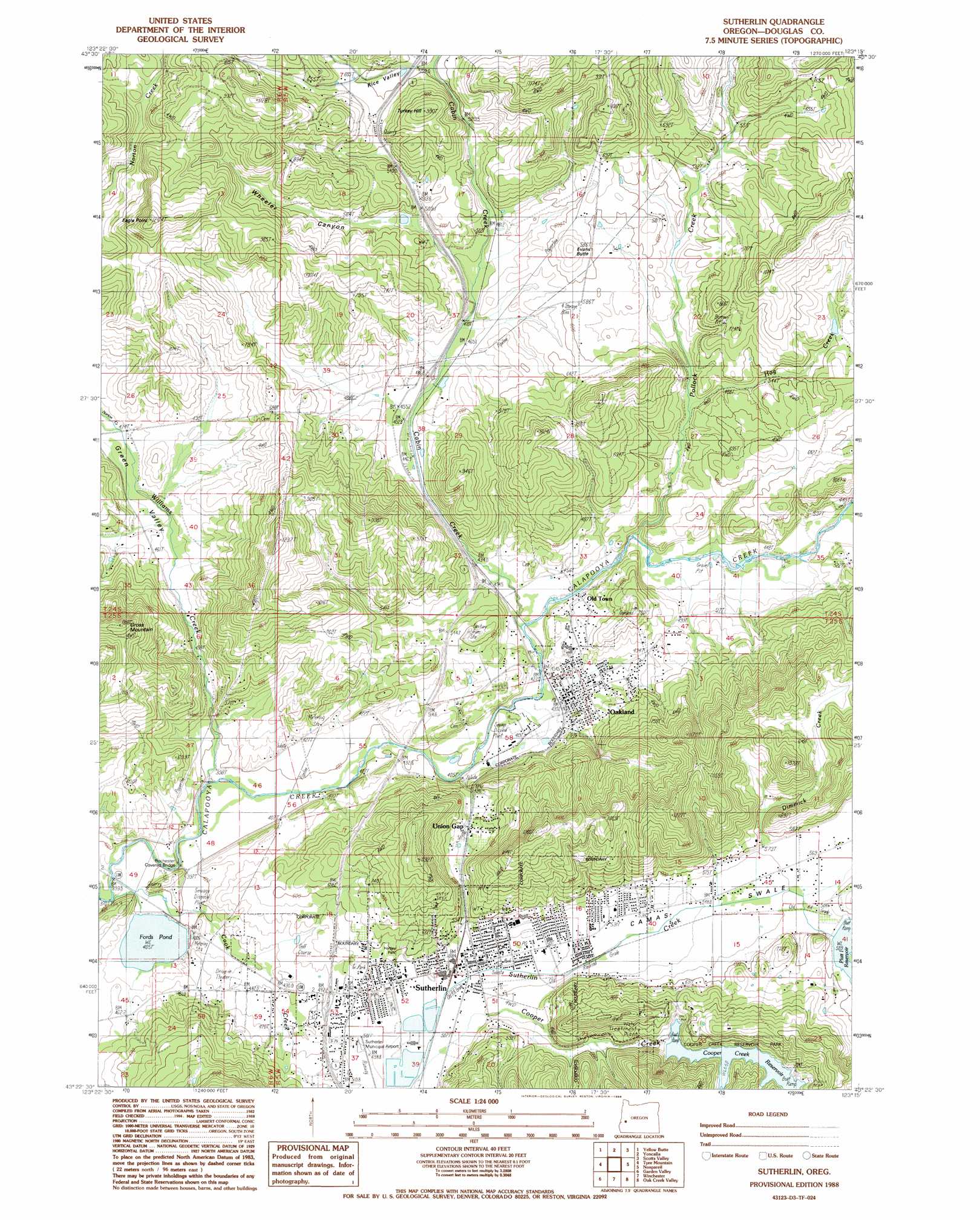
Sutherlin Topo Map Oregon
To zoom in, hover over the map of Sutherlin
USGS Topo Quad 43123d3 - 1:24,000 scale
| Topo Map Name: | Sutherlin |
| USGS Topo Quad ID: | 43123d3 |
| Print Size: | ca. 21 1/4" wide x 27" high |
| Southeast Coordinates: | 43.375° N latitude / 123.25° W longitude |
| Map Center Coordinates: | 43.4375° N latitude / 123.3125° W longitude |
| U.S. State: | OR |
| Filename: | o43123d3.jpg |
| Download Map JPG Image: | Sutherlin topo map 1:24,000 scale |
| Map Type: | Topographic |
| Topo Series: | 7.5´ |
| Map Scale: | 1:24,000 |
| Source of Map Images: | United States Geological Survey (USGS) |
| Alternate Map Versions: |
Sutherlin OR 1988, updated 1988 Download PDF Buy paper map Sutherlin OR 2011 Download PDF Buy paper map Sutherlin OR 2014 Download PDF Buy paper map |
1:24,000 Topo Quads surrounding Sutherlin
Elkton |
Putnam Valley |
Drain |
Curtin |
Cottage Grove Lake |
Kellogg |
Yellow Butte |
Yoncalla |
Scotts Valley |
Harness Mountain |
Tyee |
Tyee Mountain |
Sutherlin |
Nonpareil |
Hinkle Creek |
Callahan |
Garden Valley |
Winchester |
Oak Creek Valley |
Glide |
Reston |
Roseburg West |
Roseburg East |
Dixonville |
Lane Mountain |
> Back to 43123a1 at 1:100,000 scale
> Back to 43122a1 at 1:250,000 scale
> Back to U.S. Topo Maps home
Sutherlin topo map: Gazetteer
Sutherlin: Airports
Sutherlin Municipal Airport elevation 152m 498′Sutherlin: Bridges
Rochester Covered Bridge elevation 118m 387′Sutherlin: Dams
Cooper Creek Dam elevation 205m 672′Fords Pond Dam elevation 122m 400′
Ornoname 15 Dam elevation 153m 501′
Platt 1 Dam elevation 181m 593′
Sutherlin Log Pond Dam elevation 153m 501′
Sutherlin: Parks
Cooper Creek Reservoir Park elevation 205m 672′Cornwall Historical Marker elevation 138m 452′
Hartley Park elevation 184m 603′
Rice Hill State Safety Rest Area (historical) elevation 196m 643′
Stearns City Park elevation 123m 403′
Sutherlin City Park elevation 169m 554′
Sutherlin: Populated Places
Oakland elevation 137m 449′Old Town elevation 157m 515′
Sutherlin elevation 157m 515′
Union Gap elevation 155m 508′
Sutherlin: Post Offices
Oakland Post Office elevation 137m 449′Sutherlin Post Office elevation 157m 515′
Sutherlin: Reservoirs
Cooper Creek Reservoir elevation 205m 672′Fords Pond elevation 124m 406′
Martin Mill Pond elevation 129m 423′
North Douglas Log Ponds elevation 155m 508′
Platt 1 Reservoir elevation 181m 593′
Sutherlin Log Pond elevation 153m 501′
Sutherlin: Streams
Cabin Creek elevation 126m 413′Cook Creek elevation 130m 426′
Dimmick Creek elevation 168m 551′
Hog Creek elevation 144m 472′
Molinari Creek elevation 168m 551′
Norton Creek elevation 148m 485′
Oldham Creek elevation 137m 449′
Pollock Creek elevation 135m 442′
Williams Creek elevation 117m 383′
Sutherlin: Summits
Eagle Point elevation 361m 1184′Evans Butte elevation 224m 734′
Turkey Hill elevation 285m 935′
Sutherlin: Valleys
Camas Swale elevation 157m 515′Green Valley elevation 139m 456′
Rice Valley elevation 193m 633′
Wheeler Canyon elevation 153m 501′
Sutherlin digital topo map on disk
Buy this Sutherlin topo map showing relief, roads, GPS coordinates and other geographical features, as a high-resolution digital map file on DVD: