Tyee Mountain Topo Map Oregon
To zoom in, hover over the map of Tyee Mountain
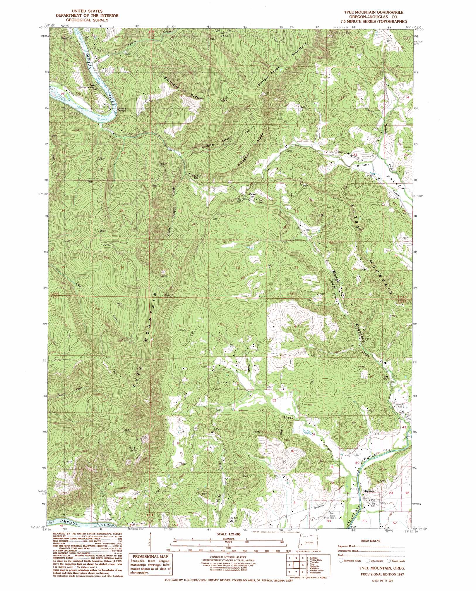
USGS Topo Quad 43123d4 - 1:24,000 scale
| Topo Map Name: | Tyee Mountain |
| USGS Topo Quad ID: | 43123d4 |
| Print Size: | ca. 21 1/4" wide x 27" high |
| Southeast Coordinates: | 43.375° N latitude / 123.375° W longitude |
| Map Center Coordinates: | 43.4375° N latitude / 123.4375° W longitude |
| U.S. State: | OR |
| Filename: | o43123d4.jpg |
| Download Map JPG Image: | Tyee Mountain topo map 1:24,000 scale |
| Map Type: | Topographic |
| Topo Series: | 7.5´ |
| Map Scale: | 1:24,000 |
| Source of Map Images: | United States Geological Survey (USGS) |
| Alternate Map Versions: |
Tyee Mountain OR 1987, updated 1987 Download PDF Buy paper map Tyee Mountain OR 2011 Download PDF Buy paper map Tyee Mountain OR 2014 Download PDF Buy paper map |
1:24,000 Topo Quads surrounding Tyee Mountain
Devils Graveyard |
Elkton |
Putnam Valley |
Drain |
Curtin |
Old Blue |
Kellogg |
Yellow Butte |
Yoncalla |
Scotts Valley |
Kelly Butte |
Tyee |
Tyee Mountain |
Sutherlin |
Nonpareil |
Cedar Creek |
Callahan |
Garden Valley |
Winchester |
Oak Creek Valley |
Mount Gurney |
Reston |
Roseburg West |
Roseburg East |
Dixonville |
> Back to 43123a1 at 1:100,000 scale
> Back to 43122a1 at 1:250,000 scale
> Back to U.S. Topo Maps home
Tyee Mountain topo map: Gazetteer
Tyee Mountain: Bridges
Bullock Bridge elevation 58m 190′Tyee Mountain: Populated Places
Stephens elevation 116m 380′Tyee Mountain: Post Offices
Stephens Post Office (historical) elevation 116m 380′Tyee Mountain: Ridges
Galagher Ridge elevation 411m 1348′Spooner Ridge elevation 505m 1656′
Tyee Mountain: Streams
Coon Creek elevation 114m 374′Dodge Canyon Creek elevation 116m 380′
Little Canyon Creek elevation 324m 1062′
Yellow Creek elevation 62m 203′
Tyee Mountain: Summits
Gross Mountain elevation 428m 1404′Marvin Hill elevation 192m 629′
Mavin Hill elevation 294m 964′
Tyee Mountain elevation 747m 2450′
Yellow Creek Mountain elevation 663m 2175′
Tyee Mountain: Valleys
Dodge Canyon elevation 118m 387′Galagher Canyon elevation 150m 492′
Little Canyon elevation 73m 239′
Tyee Mountain digital topo map on disk
Buy this Tyee Mountain topo map showing relief, roads, GPS coordinates and other geographical features, as a high-resolution digital map file on DVD: