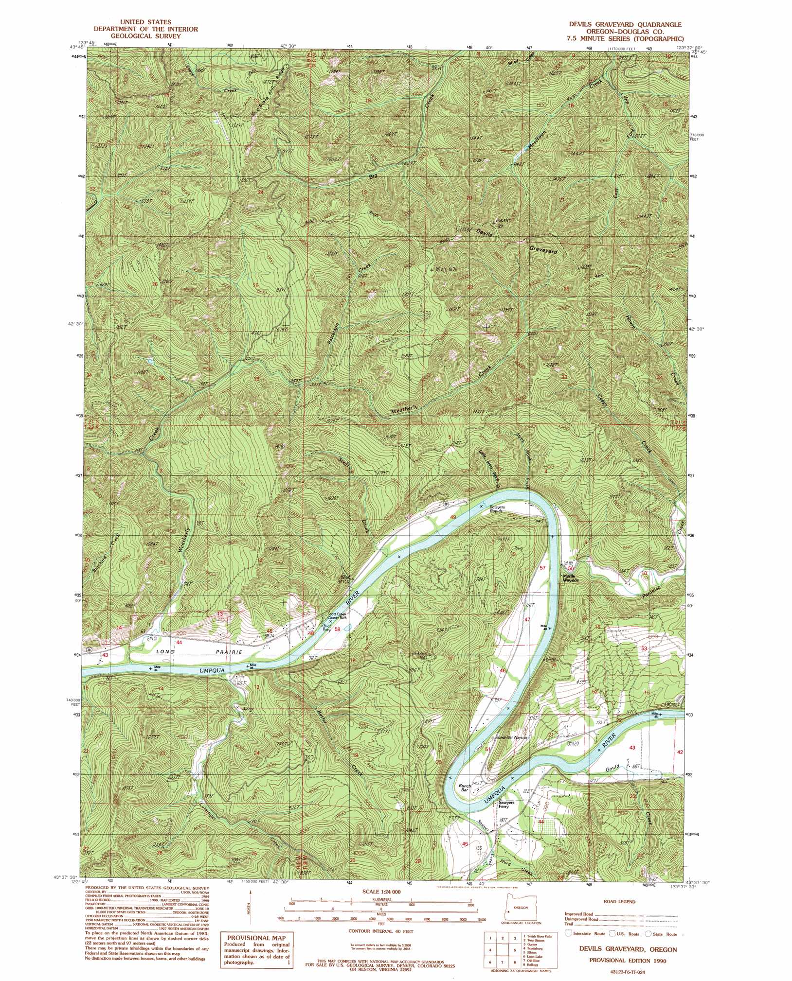
Devils Graveyard Topo Map Oregon
To zoom in, hover over the map of Devils Graveyard
USGS Topo Quad 43123f6 - 1:24,000 scale
| Topo Map Name: | Devils Graveyard |
| USGS Topo Quad ID: | 43123f6 |
| Print Size: | ca. 21 1/4" wide x 27" high |
| Southeast Coordinates: | 43.625° N latitude / 123.625° W longitude |
| Map Center Coordinates: | 43.6875° N latitude / 123.6875° W longitude |
| U.S. State: | OR |
| Filename: | o43123f6.jpg |
| Download Map JPG Image: | Devils Graveyard topo map 1:24,000 scale |
| Map Type: | Topographic |
| Topo Series: | 7.5´ |
| Map Scale: | 1:24,000 |
| Source of Map Images: | United States Geological Survey (USGS) |
| Alternate Map Versions: |
Devils Graveyard OR 1990, updated 1990 Download PDF Buy paper map Devils Graveyard OR 2011 Download PDF Buy paper map Devils Graveyard OR 2014 Download PDF Buy paper map |
1:24,000 Topo Quads surrounding Devils Graveyard
Goodwin Peak |
Baldy Mountain |
Roman Nose Mountain |
Clay Creek |
High Point |
North Fork |
Smith River Falls |
Twin Sisters |
Gunter |
Beaver Creek |
Deer Head Point |
Scottsburg |
Devils Graveyard |
Elkton |
Putnam Valley |
Eck Peak |
Loon Lake |
Old Blue |
Kellogg |
Yellow Butte |
Golden Falls |
Ivers Peak |
Kelly Butte |
Tyee |
Tyee Mountain |
> Back to 43123e1 at 1:100,000 scale
> Back to 43122a1 at 1:250,000 scale
> Back to U.S. Topo Maps home
Devils Graveyard topo map: Gazetteer
Devils Graveyard: Areas
Devils Graveyard elevation 466m 1528′Devils Graveyard: Bars
Bunch Bar elevation 32m 104′Devils Graveyard: Flats
Long Prairie elevation 15m 49′Devils Graveyard: Parks
Bunch Bar Wayside elevation 34m 111′Scott Creek County Park elevation 21m 68′
Umpqua Myrtle State Park elevation 15m 49′
Devils Graveyard: Rapids
Sawyer Rapids elevation 19m 62′Devils Graveyard: Streams
Butler Creek elevation 9m 29′Cedar Creek elevation 42m 137′
East Fork Mosetowm Creek elevation 144m 472′
Gould Creek elevation 23m 75′
Grabb Creek elevation 16m 52′
Hurd Creek elevation 32m 104′
Little Paradise Creek elevation 29m 95′
Little Stony Brook Creek elevation 13m 42′
Lutsinger Creek elevation 9m 29′
Paradise Creek elevation 15m 49′
Patterson Creek elevation 106m 347′
Sawyer Creek elevation 22m 72′
Scott Creek elevation 20m 65′
Stony Brook elevation 13m 42′
Weatherly Creek elevation 10m 32′
Devils Graveyard digital topo map on disk
Buy this Devils Graveyard topo map showing relief, roads, GPS coordinates and other geographical features, as a high-resolution digital map file on DVD: