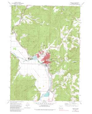
Coquille Topo Map Oregon
To zoom in, hover over the map of Coquille
USGS Topo Quad 43124b2 - 1:24,000 scale
| Topo Map Name: | Coquille |
| USGS Topo Quad ID: | 43124b2 |
| Print Size: | ca. 21 1/4" wide x 27" high |
| Southeast Coordinates: | 43.125° N latitude / 124.125° W longitude |
| Map Center Coordinates: | 43.1875° N latitude / 124.1875° W longitude |
| U.S. State: | OR |
| Filename: | o43124b2.jpg |
| Download Map JPG Image: | Coquille topo map 1:24,000 scale |
| Map Type: | Topographic |
| Topo Series: | 7.5´ |
| Map Scale: | 1:24,000 |
| Source of Map Images: | United States Geological Survey (USGS) |
| Alternate Map Versions: |
Coquille OR 1971, updated 1973 Download PDF Buy paper map Coquille OR 2011 Download PDF Buy paper map Coquille OR 2014 Download PDF Buy paper map |
1:24,000 Topo Quads surrounding Coquille
> Back to 43124a1 at 1:100,000 scale
> Back to 43124a1 at 1:250,000 scale
> Back to U.S. Topo Maps home
Coquille topo map: Gazetteer
Coquille: Dams
Johnson Log Storage and Sorting Dam elevation 3m 9′Rink Creek Dam elevation 123m 403′
Coquille: Mines
Overland Mine elevation 32m 104′Coquille: Parks
5th Street Park elevation 13m 42′Coquille Boat Ramp elevation 3m 9′
Fortier Field elevation 35m 114′
Lions Club Park elevation 14m 45′
Penny Sturdivant Park elevation 5m 16′
Sanford Heights Park elevation 18m 59′
Sanford Heights Playground elevation 18m 59′
Coquille: Populated Places
Cedar Point elevation 6m 19′Coaledo elevation 11m 36′
Coquille elevation 16m 52′
Coquille: Post Offices
Coaledo Post Office (historical) elevation 11m 36′Coquille Post Office elevation 16m 52′
Coquille: Reservoirs
George Reservoir elevation 42m 137′Johnson Log Storage and Storing Reservoir elevation 3m 9′
Rink Creek Reservoir elevation 126m 413′
Coquille: Streams
Anderson Creek elevation 3m 9′Beaver Creek elevation 6m 19′
Budd Creek elevation 7m 22′
Calloway Creek elevation 12m 39′
Coffee Creek elevation 22m 72′
Cold Creek elevation 24m 78′
Crystal Creek elevation 3m 9′
Cunningham Creek elevation 4m 13′
Dufoe Creek elevation 9m 29′
Dye Creek elevation 18m 59′
Fall Creek elevation 39m 127′
Fat Elk Creek elevation 3m 9′
Glen Aiken Creek elevation 4m 13′
Harlin Creek elevation 7m 22′
Myers Creek elevation 25m 82′
North Fork Glen Aiken Creek elevation 35m 114′
Phil Creek elevation 18m 59′
Pulaski Creek elevation 6m 19′
Reservoir Creek elevation 11m 36′
Rink Creek elevation 3m 9′
Walker Creek elevation 44m 144′
Coquille: Summits
Budd Mountain elevation 116m 380′Noble Hill elevation 259m 849′
Shuck Mountain elevation 291m 954′
Coquille: Valleys
Dunham Gulch elevation 13m 42′Dutch John Ravine elevation 13m 42′
Garden Gulch elevation 11m 36′
Hungry Hollow elevation 24m 78′
Coquille digital topo map on disk
Buy this Coquille topo map showing relief, roads, GPS coordinates and other geographical features, as a high-resolution digital map file on DVD:


