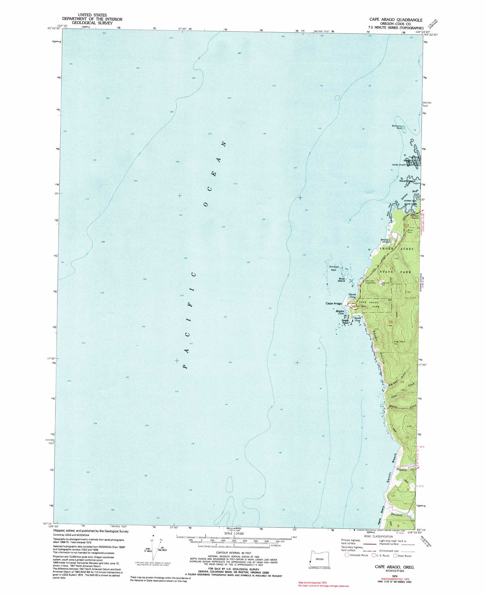
Cape Arago Topo Map Oregon
To zoom in, hover over the map of Cape Arago
USGS Topo Quad 43124c4 - 1:24,000 scale
| Topo Map Name: | Cape Arago |
| USGS Topo Quad ID: | 43124c4 |
| Print Size: | ca. 21 1/4" wide x 27" high |
| Southeast Coordinates: | 43.25° N latitude / 124.375° W longitude |
| Map Center Coordinates: | 43.3125° N latitude / 124.4375° W longitude |
| U.S. State: | OR |
| Filename: | o43124c4.jpg |
| Download Map JPG Image: | Cape Arago topo map 1:24,000 scale |
| Map Type: | Topographic |
| Topo Series: | 7.5´ |
| Map Scale: | 1:24,000 |
| Source of Map Images: | United States Geological Survey (USGS) |
| Alternate Map Versions: |
Cape Arago OR 1970, updated 1973 Download PDF Buy paper map Cape Arago OR 1970, updated 1992 Download PDF Buy paper map Cape Arago OR 2011 Download PDF Buy paper map Cape Arago OR 2014 Download PDF Buy paper map |
1:24,000 Topo Quads surrounding Cape Arago
Lakeside |
||||
Empire |
North Bend |
|||
Cape Arago |
Charleston |
Coos Bay |
||
Bullards |
Riverton |
Coquille |
||
Bandon |
Bill Peak |
Myrtle Point |
> Back to 43124a1 at 1:100,000 scale
> Back to 43124a1 at 1:250,000 scale
> Back to U.S. Topo Maps home
Cape Arago topo map: Gazetteer
Cape Arago: Bars
Simpson Reef elevation 0m 0′Cape Arago: Bays
Middle Cove elevation 0m 0′North Cove elevation 0m 0′
South Cove elevation 0m 0′
Sunset Bay elevation 0m 0′
Cape Arago: Beaches
Agate Beach elevation 5m 16′Sacchi Beach elevation 6m 19′
Cape Arago: Capes
Cape Arago elevation 4m 13′Drake Point elevation 20m 65′
Gregory Point elevation 15m 49′
Cape Arago: Cliffs
Seven Devils elevation 88m 288′Cape Arago: Flats
Cape Arago State Park elevation 91m 298′Cape Arago: Islands
Baltimore Rock elevation 0m 0′Chiefs Island elevation 10m 32′
Qochyax Island elevation 21m 68′
Shell Island elevation 0m 0′
Cape Arago: Parks
Shore Acres State Park elevation 80m 262′Cape Arago: Streams
Big Creek elevation 3m 9′Cave Creek elevation 14m 45′
First Creek elevation 7m 22′
Fivemile Creek elevation 5m 16′
Mussel Creek elevation 6m 19′
Threemile Creek elevation 5m 16′
Cape Arago: Valleys
Big Devil Gulch elevation 13m 42′Norton Gulch elevation 25m 82′
Cape Arago digital topo map on disk
Buy this Cape Arago topo map showing relief, roads, GPS coordinates and other geographical features, as a high-resolution digital map file on DVD: