North Bend Topo Map Oregon
To zoom in, hover over the map of North Bend
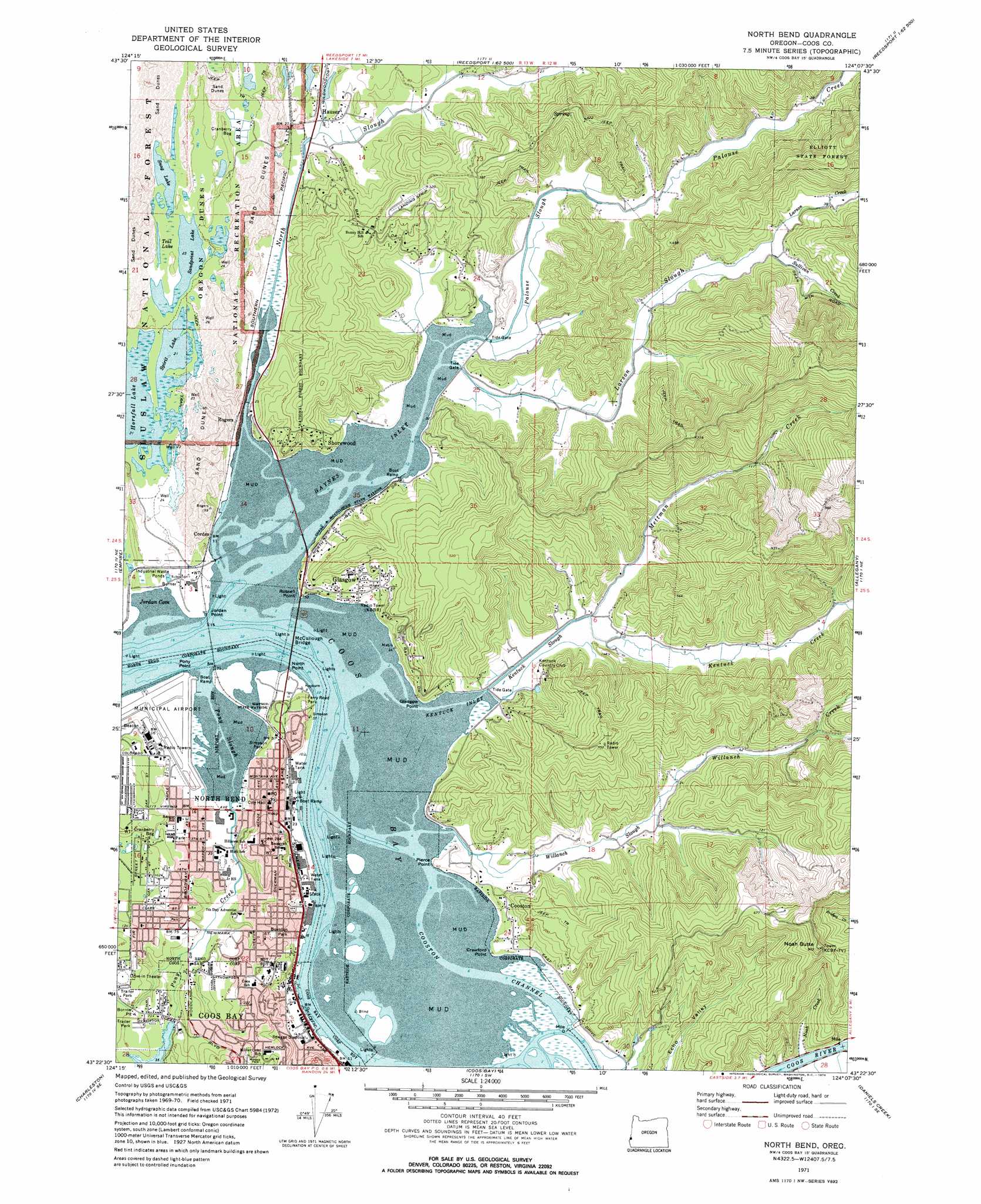
USGS Topo Quad 43124d2 - 1:24,000 scale
| Topo Map Name: | North Bend |
| USGS Topo Quad ID: | 43124d2 |
| Print Size: | ca. 21 1/4" wide x 27" high |
| Southeast Coordinates: | 43.375° N latitude / 124.125° W longitude |
| Map Center Coordinates: | 43.4375° N latitude / 124.1875° W longitude |
| U.S. State: | OR |
| Filename: | o43124d2.jpg |
| Download Map JPG Image: | North Bend topo map 1:24,000 scale |
| Map Type: | Topographic |
| Topo Series: | 7.5´ |
| Map Scale: | 1:24,000 |
| Source of Map Images: | United States Geological Survey (USGS) |
| Alternate Map Versions: |
North Bend OR 1971, updated 1974 Download PDF Buy paper map North Bend OR 2011 Download PDF Buy paper map North Bend OR 2014 Download PDF Buy paper map |
| FStopo: | US Forest Service topo North Bend is available: Download FStopo PDF Download FStopo TIF |
1:24,000 Topo Quads surrounding North Bend
Winchester Bay |
Reedsport |
Deer Head Point |
||
Lakeside |
Trail Butte |
Eck Peak |
||
Empire |
North Bend |
Allegany |
Golden Falls |
|
Cape Arago |
Charleston |
Coos Bay |
Daniels Creek |
Coos Mountain |
Bullards |
Riverton |
Coquille |
Mckinley |
Dora |
> Back to 43124a1 at 1:100,000 scale
> Back to 43124a1 at 1:250,000 scale
> Back to U.S. Topo Maps home
North Bend topo map: Gazetteer
North Bend: Airports
Bay Area Hospital Heliport elevation 10m 32′Menasha Pad elevation 0m 0′
Southwest Oregon Regional Airport elevation 5m 16′
Sunnyhill Airfield elevation 93m 305′
North Bend: Bays
Coos Bay elevation 0m 0′Haynes Inlet elevation 0m 0′
Jordan Cove elevation 0m 0′
Kentuck Inlet elevation 0m 0′
Willanch Inlet elevation 0m 0′
North Bend: Bridges
McCullough Memorial Bridge elevation 0m 0′North Bend: Capes
Crawford Point elevation 6m 19′Glasgow Point elevation 1m 3′
Jordan Point elevation 7m 22′
North Point elevation 1m 3′
Pierce Point elevation 1m 3′
Pony Point elevation 1m 3′
Russell Point elevation 0m 0′
North Bend: Channels
Cooston Channel elevation 0m 0′Ferndale Lower Range elevation 0m 0′
Ferndale Upper Range elevation 0m 0′
North Bend Lower Range Channel elevation 0m 0′
North Bend Range elevation 0m 0′
North Bend Upper Range elevation 0m 0′
North Bend: Dams
Lower Pony Creek Dam elevation 12m 39′North Bend: Guts
Pony Slough elevation 0m 0′North Bend: Islands
Lone Rock elevation 0m 0′North Bend: Lakes
Horsfall Lake elevation 7m 22′Sandpoint Lake elevation 8m 26′
Snag Lake elevation 10m 32′
Spirit Lake elevation 7m 22′
Teal Lake elevation 12m 39′
North Bend: Parks
Boynton Park elevation 25m 82′California Boat Ramp elevation 8m 26′
College Park elevation 38m 124′
Conde B McCullough State Recreation Site elevation 2m 6′
Ferry Road Park elevation 18m 59′
Oak Street Park elevation 29m 95′
Simpson Park elevation 5m 16′
State Street Park elevation 34m 111′
Winsor Park elevation 26m 85′
North Bend: Populated Places
Cooston elevation 14m 45′Glasgow elevation 29m 95′
Hauser elevation 7m 22′
North Bend elevation 14m 45′
Shorewood elevation 57m 187′
North Bend: Post Offices
Bangor Post Office (historical) elevation 8m 26′Cooston Post Office (historical) elevation 14m 45′
Hauser Post Office (historical) elevation 7m 22′
Kentuck Slough Post Office (historical) elevation 3m 9′
May Post Office (historical) elevation 3m 9′
Navy 10146 Post Office (historical) elevation 3m 9′
North Bend Post Office elevation 15m 49′
Pony Village Post Office (historical) elevation 17m 55′
North Bend: Reservoirs
Lake Merritt elevation 12m 39′Lyons Reservoir elevation 13m 42′
North Bend: Streams
Grange Creek elevation 6m 19′Johnston Creek elevation 6m 19′
Kentuck Creek elevation 3m 9′
Kentuck Slough elevation 3m 9′
Larson Creek elevation 7m 22′
Larson Slough elevation 0m 0′
Mettman Creek elevation 4m 13′
Noah Creek elevation 3m 9′
North Slough elevation 0m 0′
Palouse Creek elevation 0m 0′
Palouse Slough elevation 1m 3′
Pony Creek elevation 0m 0′
Sullivan Creek elevation 7m 22′
Willanch Creek elevation 6m 19′
Willanch Slough elevation 0m 0′
North Bend: Summits
Noah Butte elevation 275m 902′North Bend: Valleys
Ingersoll Gulch elevation 7m 22′North Bend digital topo map on disk
Buy this North Bend topo map showing relief, roads, GPS coordinates and other geographical features, as a high-resolution digital map file on DVD: