Lakeside Topo Map Oregon
To zoom in, hover over the map of Lakeside
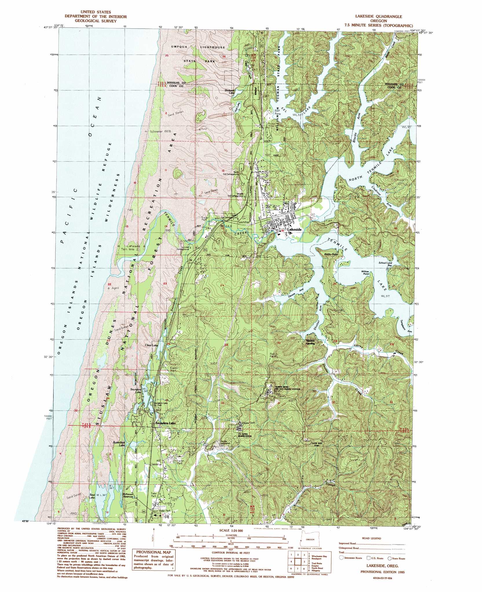
USGS Topo Quad 43124e2 - 1:24,000 scale
| Topo Map Name: | Lakeside |
| USGS Topo Quad ID: | 43124e2 |
| Print Size: | ca. 21 1/4" wide x 27" high |
| Southeast Coordinates: | 43.5° N latitude / 124.125° W longitude |
| Map Center Coordinates: | 43.5625° N latitude / 124.1875° W longitude |
| U.S. State: | OR |
| Filename: | o43124e2.jpg |
| Download Map JPG Image: | Lakeside topo map 1:24,000 scale |
| Map Type: | Topographic |
| Topo Series: | 7.5´ |
| Map Scale: | 1:24,000 |
| Source of Map Images: | United States Geological Survey (USGS) |
| Alternate Map Versions: |
Lakeside OR 1985, updated 1985 Download PDF Buy paper map Lakeside OR 2011 Download PDF Buy paper map Lakeside OR 2014 Download PDF Buy paper map |
| FStopo: | US Forest Service topo Lakeside is available: Download FStopo PDF Download FStopo TIF |
1:24,000 Topo Quads surrounding Lakeside
Tahkenitch Creek |
Fivemile Creek |
North Fork |
||
Winchester Bay |
Reedsport |
Deer Head Point |
||
Lakeside |
Trail Butte |
Eck Peak |
||
Empire |
North Bend |
Allegany |
Golden Falls |
|
Cape Arago |
Charleston |
Coos Bay |
Daniels Creek |
Coos Mountain |
> Back to 43124e1 at 1:100,000 scale
> Back to 43124a1 at 1:250,000 scale
> Back to U.S. Topo Maps home
Lakeside topo map: Gazetteer
Lakeside: Airports
Barkers Field elevation 66m 216′Lakeside State Airport elevation 11m 36′
Lakeside: Bays
Blacks Arm elevation 4m 13′Devore Arm elevation 4m 13′
Lindros Arm elevation 5m 16′
School Land Bay elevation 4m 13′
Shutter Arm elevation 4m 13′
Lakeside: Capes
Rocky Point elevation 50m 164′Willow Point elevation 11m 36′
Lakeside: Lakes
Beale Lake elevation 12m 39′Butterfield Lake elevation 15m 49′
Clear Lake elevation 11m 36′
Eel Lake elevation 20m 65′
Hall Lake elevation 49m 160′
North Tenmile Lake elevation 4m 13′
Saunders Lake elevation 13m 42′
Shuttpelz Lake elevation 60m 196′
Tenmile Lake elevation 4m 13′
Lakeside: Parks
Hauser Dune Tract elevation 15m 49′Lakeside 6th Street Boat Ramp elevation 6m 19′
Lakeside 8th Street Boat Ramp elevation 5m 16′
Middle Eel Campground (historical) elevation 13m 42′
Saunders Lake Boat Ramp elevation 17m 55′
South Eel Campground (historical) elevation 10m 32′
Tenmile Lake County Park elevation 5m 16′
William M Tugman State Park elevation 42m 137′
Lakeside: Populated Places
Lakeside elevation 7m 22′Saunders Lake elevation 28m 91′
Tenmile elevation 5m 16′
Lakeside: Post Offices
Lake Post Office (historical) elevation 7m 22′Lakeside Post Office elevation 7m 22′
Lakeside: Reservoirs
McKeown Reservoir elevation 15m 49′Lakeside: Streams
Adams Creek elevation 8m 26′Blacks Creek elevation 5m 16′
Charlotte Creek elevation 26m 85′
Clear Creek elevation 20m 65′
Eel Creek elevation 5m 16′
Saunders Creek elevation 4m 13′
Shutter Creek elevation 8m 26′
Tenmile Creek elevation 2m 6′
Lakeside digital topo map on disk
Buy this Lakeside topo map showing relief, roads, GPS coordinates and other geographical features, as a high-resolution digital map file on DVD: